Civil Station, Idukki

Civil Station, Idukki

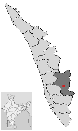
Idukki has an area of 5,105.22 km² (1,971.1 sq mi) and is the second largest District of Kerala. Rugged mountains and forests cover about 97 percent of the total area of the District. The district borders the Kerala districts of Pathanamthitta to the south, Kottayam to the southeast, Ernakulam to the northeast and Thrissur to the north and Coimbature, Dindigul and Theni District s in Tamil Nadu to the east.

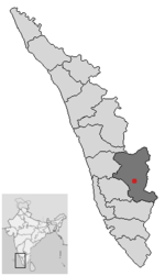
Idukki district and town in Kerala

The District headquarters -Civil Station is situated at Kuyilimala, Painavu.Kuyilimala literally translates to the Cuckoo ('Kuyil')hills ('mala').


Wikimedia Foundation. 2010.

Игры ⚽ Поможем написать курсовую

Look at other dictionaries:

  • Painavu — is the headquarters of the Idukki District of Kerala India.Nearest Airport: Cochin International Airport,Nedumbassery 120 km Nearest Railhead: Angamaly 114 km Altitude:800 1000 metres above sea level Co ordinates: 9°50 52 N 76°56 32 E Road… …   Wikipedia

  • Cherthala —   taluk   …   Wikipedia

  • North Paravur — This article is about a town in Ernakulam district. For other uses, see Paravur. Paravur   suburb   …   Wikipedia

  • Kollam — (കൊല്ലം) Quilon   city   …   Wikipedia

  • Malappuram — This article is about the municipality in Kerala, India. For its namesake district, see Malappuram district. Malappuram   city   …   Wikipedia

  • Muvattupuzha Taluk — This article is about the Taluk Muvattupuzha. For the Town, see Muvattupuzha. Muvattupuzha Moovattupuzha   taluk/village   Coordinates Country India …   Wikipedia

  • Palakkad district — Infobox Indian Jurisdiction native name=Palakkad type= district hq=Palakkad latd = 10.775 longd= 76.651 state name=Kerala abbreviation=IN KL PKD collector=K. AjayaKumar area=4,480 area magnitude=9 |population total = 2617482 population year= 2004 …   Wikipedia

  • Pathanamthitta — Infobox Indian Jurisdiction native name = PATHANAMTHITTA | type = town | latd = 9.27 | longd = 76.78 locator position = left | state name = Kerala district = Pathanamthitta leader title = leader name = altitude = 19 population as of = 2001… …   Wikipedia

  • Kottayam — This article is about the municipality in Kerala, India. For its namesake district, see Kottayam district. For Pazhassi Raja s Kottayam kingdom, see Kottayam (Malabar). Kottayam കോട്ടയം Akshara Nagari   city   …   Wikipedia

  • Kottayam district — Infobox Indian Jurisdiction native name=Kottayam type=district hq= Kottayam latd = 9.595 longd=76.531 state name=Kerala abbreviation=IN KL collector= Raju Narayana Swamy area=2,203 area magnitude=9 population total = 1953646 population year= 2001 …   Wikipedia

Share the article and excerpts

Direct link
Do a right-click on the link above
and select “Copy Link”