- Old Blenheim Bridge
-
Old Blenheim Bridge 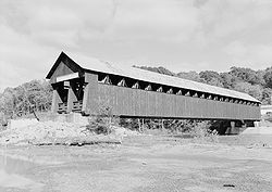
HAER photo in 2004Carries Vehicles (1855–1936)
Pedestrians (1936–2011)Crosses Schoharie Creek Locale North Blenheim, NY Designer Nichols M. Powers[1][2] Design double-barreled Long truss with center arch covered bridge[3][4] Total length 232 ft 0 in (70.7 m)[2] Width 26 ft 3 in (8.0 m)[2] Height 30 feet (9.1 m)[2] Longest span 210 feet (64 m)[2] Opened 1855[3] Collapsed August 28, 2011 Old Blenheim Bridge

Location: North Blenheim, NY Coordinates: 42°28′21.11″N 74°26′28.58″W / 42.4725306°N 74.4412722°WCoordinates: 42°28′21.11″N 74°26′28.58″W / 42.4725306°N 74.4412722°W Area: Schoharie County Built: 1854–1855 Architect: Nichols Montgomery Powers Governing body: Local NRHP Reference#: 66000570 Significant dates Added to NRHP: October 15, 1966[5] Designated NHL: January 29, 1964[6] Old Blenheim Bridge was a wooden covered bridge that spanned Schoharie Creek in North Blenheim, New York. With an open span of 210 feet (64 m), it had the longest span of any surviving covered bridge in the world; although the structure's total length, made it second in that respect to the Bridgeport Covered Bridge (233 feet (71 m) long with a 208 feet (63 m) clear span).[3] The bridge, opened in 1855, was also one of the oldest of its type in the United States. It was destroyed on August 28, 2011 as a result of flooding from Tropical Storm Irene.
Contents
History
 "Nichols M. Powers" headstone
Nichols Montgomery Powers[1][2] was brought in from Vermont to build the bridge by a group of local business men who formed the Blenheim Bridge Company for the purpose of constructing this bridge. The bridge opened in 1855, and remained in use for vehicles until 1932, when a steel truss bridge was constructed near-by. Since then, the bridge was maintained as a historic site open to pedestrians.[3] It was declared a National Historic Landmark in 1964.[6][7]
On August 28, 2011, record flooding along the Schoharie Creek, due to Tropical Storm Irene, resulted in the bridge being washed away and completely destroyed.[8]
Longest bridge
Many sources simply claimed the Old Blenheim Bridge was the longest surviving single-span covered bridge, without getting into span-length vs. total-length. There are also sources that claim the Bridgeport Covered Bridge in California is longer. The New York Covered Bridge Society states that Blenheim bridge was 2 feet longer than "a bridge in California" (presumably Bridgeport), in terms of clear span. Blenheim's clear span was originally 219 feet, according to this website.
A report by the U.S. Department of the Interior states that the Bridgeport Covered Bridge (HAER No. CA-41) has clear spans of 210 feet (64 m) on one side and 208 feet (63 m) on the other, while Blenheim Bridge (HAER No. NY-331) had a documented clear span of 210 feet (64 m) in the middle (1936 HABS drawings). In August 2003, measurements of post-repair Blenheim Bridge abutments were 209 feet 2 inches (63.75 m) on the upstream side, and 205 feet 6 inches (62.64 m) on the downstream side.[2]
Historically, the longest single-span covered bridge on record was Pennsylvania's McCall's Ferry Bridge with a claimed clear span of 360 feet (110 m) (built 1814–15, destroyed by ice jam 1817).[2]
Gallery
-

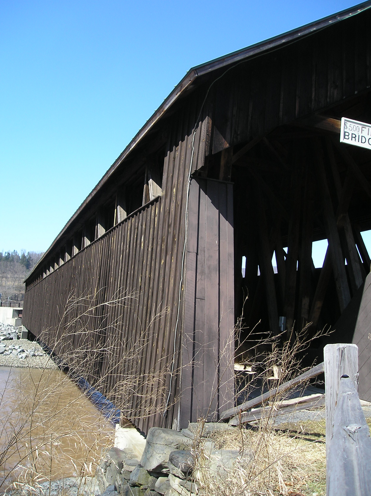
Side view of the bridge as photographed from the eastern shore
-

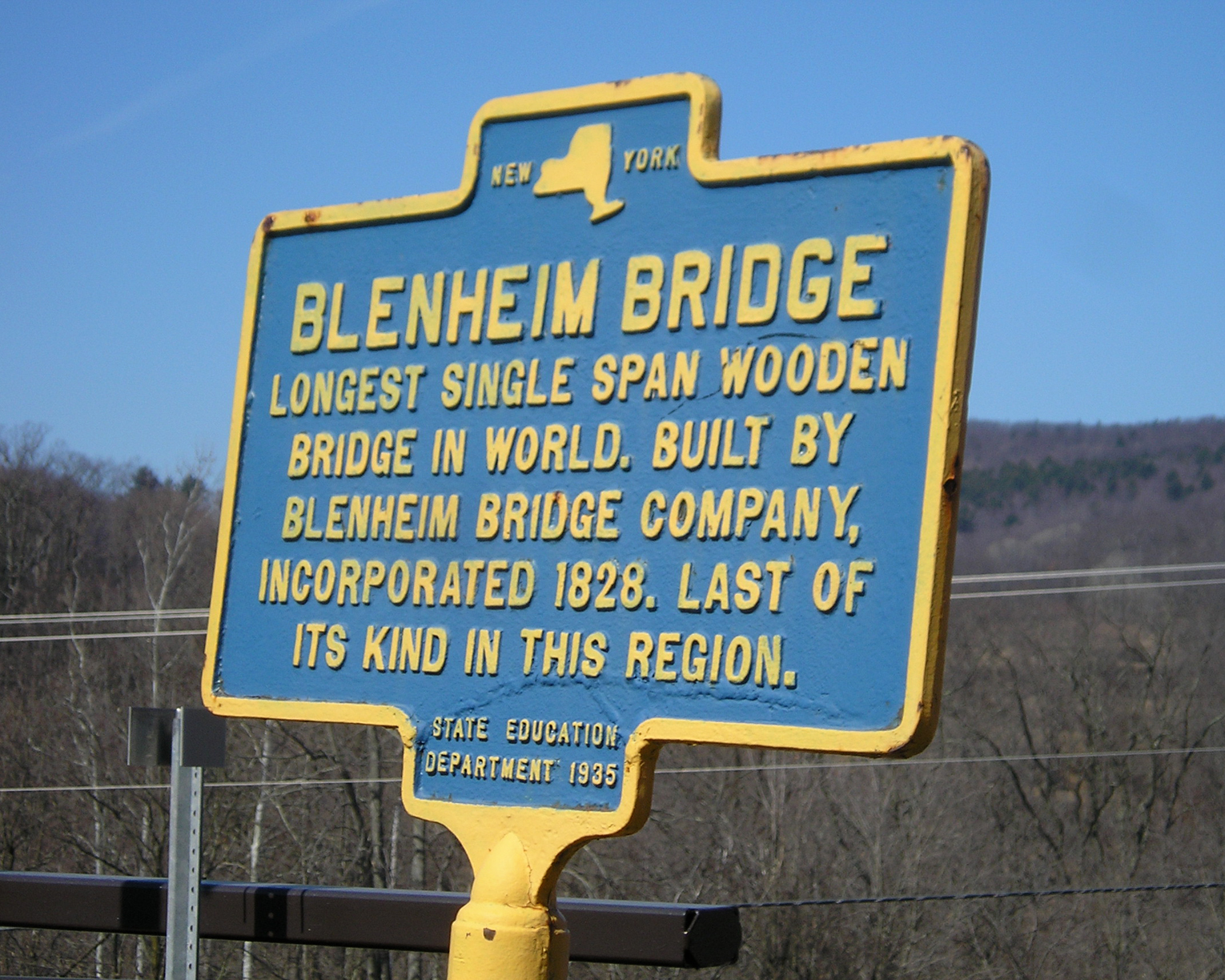
State Education Department historical marker located at the corner of Eastside Rd and Route 30 in Schoharie
-

Oblique view as photographed from up the hill on the eastern shore
-

Registered National Historic Landmark Plaque
-

The span of the Old Blenheim Bridge as photographed 11 March 2008.
See also
- Smolen-Gulf Bridge longest covered bridge (with multiple spans)
References
- ^ a b Jeffords, Jim (Winter 2004) (pdf). Common Ground, volume 9, number 4. Washington, D.C.: National Park Service, U.S. Department of the Interior. p. 2. ISSN 1087-9889. http://commonground.cr.nps.gov/pdf/CG_Winter_04.pdf. Retrieved 2010-05-30. "In 1837, the people of Pittsford, Vermont, contracted 19-year-old Nichols Powers to build a bridge over Otter Creek."
- ^ a b c d e f g h Bennett, Lola (2002–2003). "Blenheim Bridge (HAER No. NY-331)". National Covered Bridges Recording Project. Historic American Engineering Record, National Park Service, U.S. Department of the Interior. http://memory.loc.gov/cgi-bin/ampage?collId=pphhdatapage&fileName=ny/ny2000/ny2006/data/hhdatapage.db&recNum=0&itemLink=D?hh:16:./temp/.
- ^ a b c d Jackson, Donald C. (1988). Great American Bridges and Dams. Wiley. pp. 140. ISBN 0-471-14385-5.
- ^ "Blenheim Bridge". Covered Bridges of the Northeast USA. http://www.coveredbridgesite.com/ny/blenheim.html.
- ^ "National Register Information System". National Register of Historic Places. National Park Service. 2007-01-23. http://nrhp.focus.nps.gov/natreg/docs/All_Data.html.
- ^ a b "Blenheim Covered Bridge". National Historic Landmark summary listing. National Park Service. 2007-09-18. http://tps.cr.nps.gov/nhl/detail.cfm?ResourceId=412&ResourceType=Structure.
- ^ James Dillon (1974). National Register of Historic Places Registration: Old Blenheim Bridge.PDF (258 KB). National Park Service and Accompanying Photos, from 1974PDF (642 KB)
- ^ Eckholm, Erik (August 31, 2011). "Covered Bridges, Beloved Remnants of Another Era, Were Casualties, Too". The New York Times. http://www.nytimes.com/2011/09/01/us/01bridges.html?emc=tnt&tntemail0=y. Retrieved September 1, 2011.
External links
- Photos of Blenheim Covered Bridge by Douglas Kerr
- Photos of Blenheim Covered Bridge by Charles Peifer
- Blenheim Bridge, at New York State Covered Bridge Society
- Blenheim Covered Bridge, Spanning Schoharie River, North Blenheim, Schoharie County, NY: 3 drawings, 2 photos and 6 data pages, at Historic American Building Survey
- Blenheim Bridge, Spanning Schoharie Creek, River Road (now bypassed, North Blenheim, Schoharie County, NY: 13 photos, 13 data pages, and 1 photo caption page at Historic American Building Survey
- Old Blenheim Bridge at Structurae
Categories:- Bridges on the National Register of Historic Places in New York
- National Historic Landmarks in New York
- Covered bridges in New York
- Bridges completed in 1834
- Historic Civil Engineering Landmarks
- Wooden bridges in the United States
- Buildings and structures in Schoharie County, New York
- Transportation in Schoharie County, New York
- Visitor attractions in Schoharie County, New York
- Destroyed landmarks in the United States
- Road bridges in New York
- Pedestrian bridges in New York
- Former road bridges in the United States
-


Wikimedia Foundation. 2010.