- Big Timber Creek
Geobox River
name =Big Timber Creek
native_name =
other_name =
other_name1 =

image_size =
image_caption =Main stem, looking upstream (2007)
etymology =Dutch, "Timmer Kill"
country =USA
country1 =
state =New Jersey
state1 =
region =
region1 =
district =
district1 =
city =
city1 =
landmark =
landmark1 =
length_imperial =16
watershed_imperial =63
discharge_location =Delaware River
discharge_imperial =
discharge_max_imperial =
discharge_min_imperial =
discharge1_location =
discharge1_imperial =
source_name =Big Lebanon Branch
source_location =Cross Keys
source_district =
source_region =
source_state =New Jersey
source_country =
source_lat_d =39
source_lat_m =43
source_lat_s =38
source_lat_NS =N
source_long_d =75
source_long_m =01
source_long_s =28
source_long_EW =W
source_elevation_imperial =158
source_length_imperial =
mouth_name =
mouth_location =Westville
mouth_district =
mouth_region =
mouth_state =New Jersey
mouth_country =
mouth_lat_d =39
mouth_lat_m =52
mouth_lat_s =42
mouth_lat_NS =N
mouth_long_d =75
mouth_long_m =05
mouth_long_s =07
mouth_long_EW =W
mouth_elevation_imperial =0
tributary_left =
tributary_left1 =
tributary_right =
tributary_right1 =
free_name =
free_value =
map_size =
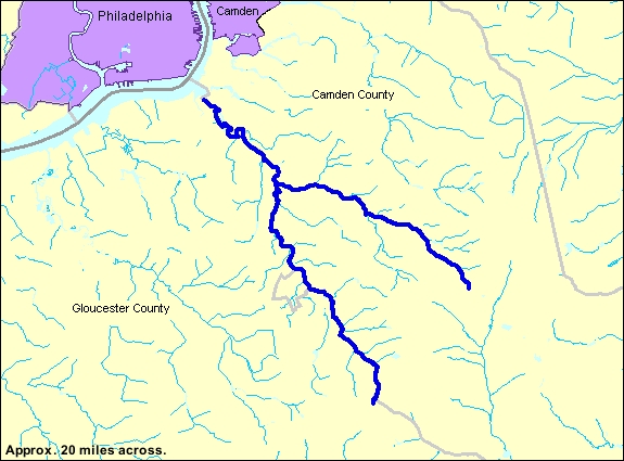
map_caption = Big Timber Creek is a stream in southwesternNew Jersey ,USA , and is also known by the name 'Tetamekanchz Kyl' by theLenape tribes. It comprises about convert|25|mi|km|1 of stream and drains convert|63|sqmi|km2|1. A tributary of theDelaware River , it enters the Delaware between the boroughs of Brooklawn and Westville, just south ofPhiladelphia ,Pennsylvania . The main stream and South Branch form about half of the border between Camden and Gloucester counties.Pre-Columbian Big Timber Creek was home to numerous villages of the Lenni Lenape . In Colonial times, the creek was a commercial waterway, and it powered a multitude of mills up through the 1950s . In the second half of 20th century it suffered the ill effects of the rapid post–World War II development that plagued many of America's waterways. As of 2007, it had recovered somewhat thanks to pollution controls and improvements in sewage treatment.
The name
First named 'Tetamekanchz' by the local
Lenape tribe, with the North Branch named Tetamekanchz, the Chew's Landing section named Arwames, Beaver Branch is called Tekoke, and Little Timber Creek is named Sassackon [Mickle, Isaac [http://www.rootsweb.com/~njgchs/Mickle.pdf] , 1845. AccessedJanuary 4 ,2008 .] . The earliest recorded use of the current name is by an early Dutch explorer, David P. DeVries, who refers to a "Timmer Kill", "Timber Creek" in Dutch, in his memoirs of his journey of 1630–1633, after the construction ofFort Nassau at its mouth. [Cleary, William E. [http://gloucestercitynews.typepad.com/clearysnotebook/2007/02/history_of_fort.html History of Fort Nassau] ,February 18 ,2007 . AccessedSeptember 5 ,2007 .] This name became anglicized when the Quakers arrived. In 1697, theWest Jersey Proprietors, in creating the town of Gloucester, decreed that the name be the "Gloucester River", and although that name did appear in documents for several years, it faded away. A much smaller creek lying to the north,Little Timber Creek , finds the Delaware at the same place as its larger namesake. To differentiate between the two, the latter came to be known as "Great Timber Creek", which soon became "Big Timber Creek." Even so, at the end of the 20th century it was still usually referred to in speech as simply "Timber Creek."Description
Course
(Note: All course mileage figures are approximate
river mile s, not as the crow flies.)Big Timber Creek flows roughly to the northwest. Two streams, the North Branch and the South Branch, join convert|4.8|mi|km|1 above its mouth to form the main stream. The South Branch is considered the source stream. Both branches are dammed at several points to form impoundments—no natural lakes occur along either branch.
outh Branch
Two streams join to form the South Branch of Big Timber Creek, the Big Lebanon Branch and the Little Lebanon Branch.
Big Lebanon is considered the source stream, as it is the longer. Indeed, it appears on some maps as "Big Timber Creek". It rises near
Cross Keys in Gloucester County (under a housing development) at an elevation of about convert|160|ft|m|1 and flows nothwesterly convert|2.5|mi|km|1, fed by several streams from the east along the way, to its confluence with the Little Lebanon Branch just above Nash's Lake in Turnersville. About a mile (1.6 km) north of its source, at the head of Jones Lake, Big Lebanon receives Long Hollow Branch. Jones Lake is formed by a dam about a quarter mile (0.4 km) on and lies at an elevation of about convert|110|ft|m|1. Just beyond the dam, Chestnut Branch comes in, and Big Lebanon veers northwest to run along the south side of theAtlantic City Expressway . A half mile (0.8 km) beyond Chestnut Branch it receives Slab Bridge Branch, and after another half mile, Jeremys Field Branch about convert|0.3|mi|km|1 above its confluence with Little Lebanon.Little Lebanon lies within Gloucester County. It begins at Baum Pond (in 2007, dry) at an elevation of about convert|135|ft|m|1 near the intersection of Stagecoach Road and the Black Horse Pike. It flows roughly north for convert|1.6|mi|km|1 to meet the Big Lebanon and with it form the South Branch of Big Timber Creek. Little Lebanon has no significant tributaries.
The South Branch proper begins just above Nash's Lake in Washington Township and runs northward for convert|9|mi|km|1 to the point where it joins the North Branch. It forms several impoundments and receives a number of smaller streams over its course. Just below its head, the South Branch passes under the Atlantic City Expressway to be dammed about a third of a mile down to form Nash's Lake at an elevation of convert|79|ft|m|1. After weaving once under the highway for about two-thirds of a mile (1 km), it receives Stone Bridge Branch and Toms Branch from the east in quick succession and, passing under the highway (now Route 42) to the west, it flows north for a mile to Grenloch Lake in Turnersville. Grenloch Lake lies at an elevation of convert|44|ft|m|1 and extends for a half mile (0.8 km) above its dam. The lake receives Holly Run from the northeast before passing under the Black Horse Pike, whereupon Bells Lake Branch enters from the south. Below Grenloch Lake's dam, the South Branch wanders northwest for a mile (1.6 km) to Blackwood Lake in Blackwood, having picked up Gardner's Run from the southwest about halfway along. At an elevation of convert|18|ft|m|1, Blackwood Lake snakes almost a mile along the foot of an
escarpment to its west. Farrows Run enters from the east about at the midpoint. About a quarter mile below the dam, two streams join the South Branch, Bull Run from the west and Minqus Run from the east. About a mile farther on, the stream grows sluggish and tidal. Another mile, and Pines Run enters from the east just after the South Branch passes under Route 42 south-to-north. Its final mile lies among wetlands and mudflats.North Branch
, which is nearer), the highest point in southern New Jersey at about convert|200|ft|m|1. The North Branch flows northwestward convert|10|mi|km|1 through several impoundments to Chews Landing and thence to its confluence with the South Branch.From its origin, the North Branch skirts the northern edge of the world-renowned
Pine Valley Golf Club and enters Lekau Lake a mile down. [Lekau Lake lies within a Boy Scout reservation, and it was renamed from "Irelands Lake" after the Lenape word for "sand" or "gravel," apparently translated "sandpiper" by theOrder of the Arrow .] A teardrop-shaped impoundment about third of a mile (0.5 km) long, Lekau Lake lies at an elevation of convert|76|ft|m|1 in a hollow of the hills. Leaving the lake, the North Branch twines its way a mile northwest, down to convert|51|ft|m|1, and enters Clementon Lake in Clementon, long a recreational mecca for the region. A quarter mile (0.4 km) below the lake Trout Run enters from the east, and a half mile farther on, Gravelly Run. The North Branch then runs more to the west for a mile to Laurel Lake, a sinuous half-mile-long (0.8 km) impoundment which lies at an elevation of about convert|30|ft|m|1. The North Branch continues its westerly course for three-quarters of a mile (1.2 km) below Laurel Lake, turning northward where Mason Run enters from the south. It turns to the westward again after another three-quarters of a mile, immediately after which it receives Signey Run from the north. The North Branch then tends northwestward, widening and slowing a mile along, and, turning west upon receiving Otter Branch from the north a half mile farther down, enters an impoundment at Chew's Landing. This impoundment is a consequence of the constriction at the point about a third of a mile (0.5 km) down where the North Branch passes under the Black Horse Pike. The North Branch is now tidal and runs westward through wetlands another mile to its confluence with the South Branch.Main stream
, just upstream from Clement's Bridge, at the confluence of the North and South branches. It meanders northwest for convert|4.8|mi|km|1 to empty into the Delaware River between Westville and Brooklawn. Over much of its length it is hemmed in by roads, old dumps, and fill. It opens out into wetlands here and there. The main stream is tidal throughout.The first mile (1.6 km) of the main stream is essentially a ditch between a housing development and a trash dump. Three-quarters of a mile (1.2 km) downstream from its head, the main stream receives from the north the waters of Hirsch Lake in Runnemede, a smallish impoundment fed by an unnamed stream. A quarter mile (0.4 km) on, the left bank recedes into wetlands, and Almonesson Creek enters on the left another quarter mile down. A further half mile (0.8 km) sees Beaver Brook enter on the right, and the stream narrows again as it passes under Route 42 and the
New Jersey Turnpike . It remains confined for the next mile and a half (2.4 km), receiving Ladd's Branch on the left at one mile and flowing another half mile to pass under Route 295, shortly after which it opens out into three-quarters of a mile of wetlands. The stream forms three channels here, the main one hugging the left bank by Westville. The last three-quarters of a mile are confined.The land
Geology
Big Timber Creek lies wholly within in the
Coastal Plain Physiographic Province, specifically that portion known as the Inner Coastal Plain. The coastal plain is a wedge-shaped mass ofsediments , mostly unconsolidated, lying uponPre-Cambrian basement rock . It extends from thefall line out onto thecontinental shelf , thickening as it goes at the rate of 80 to 100 feet per mile (15–19m/km).New Jersey's inner coastal plain is defined by a
cuesta that runs through the coastal plain roughly northeast to southwest across the middle and southern parts of the state. This cuesta marks the transition between the underlyingCretaceous sediments toward thepiedmont and the more recentMiocene sediments seaward and is itself Cretaceous in origin. In its southern reaches, where Big Timber Creek lies, it runs roughly parallel to the Delaware River at a distance of about convert|20|mi|km|0 and delineates the left edge of the Delaware River watershed in southern New Jersey.The surficial
geology of the New Jersey inner coastal plain is among the most complex in the world. At least eight of the 14 or 15 sedimentary strata, or "formations", laid down since the Cretaceous period appear at the surface in the Big Timber Creek basin. Each formation is itself made up of many layers, some the result of irregular interglacial stream deposition. The situation is further complicated by the appearance of fragments of older formations at a shallower level than more recent ones, owing to cycles of deposition anderosion ; in fact, the so-called "Bridgeton" formation, the oldest, containing iron-induratedsand , forms the summits of the few prominences on the landscape. Generally speaking, the surface of the area is weathered Cretaceous coastal plain consisting ofquartz sand, with patches wheregravel orclay are found.Glauconite occurs in varying concentrations in the younger formations, and somebog iron is seen. There is no rock, though some iron-bearing sand has become concreted and rock-like.Geography
Big Timber Creek dissects the inner coastal plain in the dendritic pattern characteristic of streams flowing over soft materials. It has been cutting down through sand, clay, and gravel since the retreat of the last of the
Pleistocene marine inundations which deposited fresh layers of sediment. Big Timber Creek's watershed encompasses 63 square miles (163.2 km²), including Little Timber Creek, a small creek that shares its mouth. The sides of the basin are defined by the patchy remains of relatively erosion-resistant formations. Nowhere in its basin does the relief exceed convert|200|ft|m|0, and much lies below convert|50|ft|m|0. What relief there is is entirely due to erosion, mostly by Big Timber Creek and itstributaries .The terrain consists mainly of a jumble of the low, flattened ridges typical of mature sandy basins. The scattered prominences of 100 feet (30m) or more, some quite steep, owe their existence to caps of iron-rich sand. A cuesta forms escarpments beyond the headwaters of the Creek and along some of its southerly tributaries. There is a small, marshy
floodplain in the lower reaches.References
ee also
*
List of New Jersey rivers External links
* [http://www.delawareriverkeeper.org/factsheets/big_timber.html Delaware Riverkeeper's page on Big Timber Creek]
* [http://www.njconservation.org/html/gfa-timber.htm New Jersey Conservation Foundation's page on Big Timber Creek]
* [http://www.bigtimbercreek.org/ The Old Pine Farm Natural Lands Trust - a land trust along the creek, much information on area wildlife]
Wikimedia Foundation. 2010.