- Kymulga Mill & Covered Bridge
Infobox_nrhp | name = Kymulga Mill
nrhp_type =
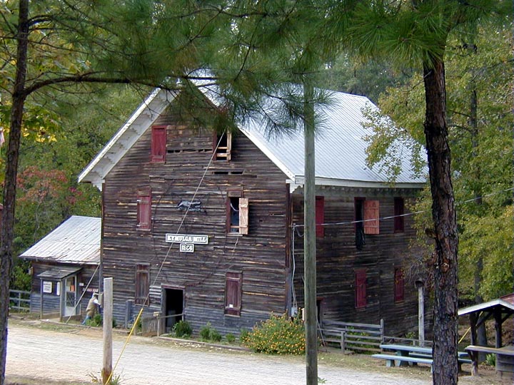
caption = Kymulga Mill near Childersburg, Alabama.
nearest_city = Childersburg, AL
lat_degrees = 33 | lat_minutes = 20 | lat_seconds = 2.38 | lat_direction = N
long_degrees = 86 | long_minutes = 17 | long_seconds = 59.67 | long_direction = W
area =
built = 1864
added =October 29 ,1976
governing_body = Local
refnum=76000356 cite web|url=http://www.nr.nps.gov/|title=National Register Information System|date=2007-08-21|work=National Register of Historic Places|publisher=U.S. National Park Service]Infobox_nrhp | name = Kymulga CB
nrhp_type =

caption = Kymulga Covered Bridge near Childersburg, Alabama.
nearest_city = Childersburg, AL
lat_degrees = 33 | lat_minutes = 20 | lat_seconds = 3.98 | lat_direction = N
long_degrees = 86 | long_minutes = 17 | long_seconds = 58.40 | long_direction = W
area =
built = 1861
added =October 29 ,1976
governing_body = Local
refnum=76000356 cite web|url=http://www.nr.nps.gov/|title=National Register Information System|date=2007-08-21|work=National Register of Historic Places|publisher=U.S. National Park Service]Infobox Bridge
bridge_name=Kymulga CB
caption=
official_name=
carries=pedestrian traffic
crosses=Talladega Creek
locale=Childersburg, Alabama
maint=Childersburg Heritage Committee
id=01-61-01 (WGCB)
design=Howe truss
mainspan=
length=105 ft (32 m)
width=
height=
load=
clearance=
below=
traffic=
begin=
complete=1861
open=
closed=
toll=
map_cue=
map_
map_text=
map_width=
coordinates= coord|33|20|2.38|N|86|17|59.67|W|region:US_type:landmark
lat=
long=Kymulga Mill & Covered Bridge are two locally owned historic landmarks located at Kymulga Park in
Talladega County, Alabama ,United States . The park is on Grist Mill Road (CR 46) off State Route 76 about 4 miles (6 kilometers) northeast of the city of Childersburg. Coordinates for the park are coor dms|33|20|2.38|N|86|17|59.67|W|city (33.333994, -86.299908).Both structures, dating back to the
American Civil War , were restored in 1974 and were listed on theNational Register of Historic Places onOctober 29 ,1976 . The Childersburg Heritage Committee purchased the tract in 1988, and with help from theAlabama Historical Commission and the Talladega County Commission, established Kymulga Park. More structural renovations were made as well. There is an admission charge to visit the park, with proceeds being used for upkeep of all structures and nature trails within this historic recreation area.Kymulga Mill
Kymulga Mill is a working
gristmill built in 1864 by German contractor G.E. Morris forConfederate Army Captain William H. Forney . Captain Forney died before construction was completed, but his wife allowed Morris to finish it.Union Army soldiers burned most of the gristmills throughout the area during the Civil War, but Kymulga Mill was missed. The mill was sold four times before being purchased by the Childersburg Heritage Committee from latest owner Edward Donahoo in 1988, though it remained in active service through many of those years.Three water powered turbines ran the four-story mill, including lights, grain elevator and
millstone s used for grinding grain. Two of its five sets are French buhrs, thought to be the hardest rock in the world. Kymulga Mill continues to operate to this day, though under electricity, still making corn meal with its huge millstones. The building is now a tourist attraction open for guided tours. It also serves as a gift shop and park office.Kymulga Covered Bridge
The Kymulga Covered Bridge is a wood & metal combination style
covered bridge that spansTalladega Creek , located just east of Kymulga Mill within Kymulga Park. Built in 1861, the 105-foot (32 m) bridge is aHowe truss construction over a single span. Its WGCB number is 01-61-01. The Kymulga Covered Bridge is one of two 19th century covered bridges extant in Alabama still remaining at its original location. Also located in Talladega County, theWaldo Covered Bridge is the other.The bridge once provided access to the Old Georgia Road, a Native American trade route which was used by settlers and frontiersmen who ventured the area. Eventually, farms and communities spawned along the former trail. The United States government purchased land adjacent to Kymulga Mill in 1941 for the Alabama Ordnance Works, a
military installation. Settlements within the tract had to be relocated. Today, the Kymulga Covered Bridge leads park visitors to a series of nature trails north of Talladega Creek. People may still find remnants of the Old Georgia Road, as well as other traces of the past.References
* Dale J. Travis Covered Bridges. [http://www.dalejtravis.com/bridge/alabama/htm/0106101.htm Kymulga MCB: Credits] . Retrieved Aug. 21, 2007.
* Bridges to the Past: Alabama's Covered Bridges. [http://www.alabamatv.org/bridges/photos.htm Kymulga MCB: Credits] . Retrieved Aug. 21, 2007.
* Alabama Bureau of Tourism & Travel. [http://www.800alabama.com/ Kymulga MCB: Credits] . Retrieved Aug. 21, 2007.
* "The Decatur Daily". [http://www.decaturdaily.com/decaturdaily/news/061101/covered.shtml Kymulga MCB: Credits] . Retrieved Aug. 21, 2007.
* Alabamiana: A Guide to Alabama. [http://www.al.com/alabamiana/index.ssf?bridges.html Kymulga MCB: Credits] . Retrieved Aug. 21, 2007.
* American Profile.com. [http://www.americanprofile.com/article/282.html Kymulga MCB:Credits] . Retrieved Aug. 21, 2007.
* Kymulga Park. [http://kymulgapark.tripod.com/index.html Kymulga MCB: Credits] . Retieved Aug, 21, 2007.ee also
*
List of Alabama covered bridges
*List of historic gristmillsExternal links
* [http://kymulgapark.tripod.com/index.html Kymulga Park (Childersburg Heritage Committee)]
* [http://www.alabamatv.org/bridges/photos.htm Bridges to the Past: Alabama's Covered Bridges]
* [http://www.dalejtravis.com/bridge/alabama/htm/0106101.htm Kymulga Covered Bridge (Dale J. Travis)]
Wikimedia Foundation. 2010.