- Tallington
-
Coordinates: 52°39′36″N 0°22′59″W / 52.66°N 0.38315°W
Tallington 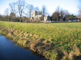
St Lawrence church in December 2005
 Tallington
Tallington shown within LincolnshirePopulation 406 (2001 Census) OS grid reference TF094081 Parish Tallington District South Kesteven Shire county Lincolnshire Region East Midlands Country England Sovereign state United Kingdom Post town STAMFORD Postcode district PE9 4xx Dialling code 01780 Police Lincolnshire Fire Lincolnshire Ambulance East Midlands EU Parliament East Midlands UK Parliament Grantham and Stamford List of places: UK • England • Lincolnshire Tallington is a small village of around 200 houses, situated four miles east of Stamford in South Kesteven, on the southern edge of Lincolnshire, next to the borough of Peterborough.
Contents
Geography
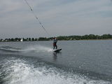 Waterskiing on Tallington Lakes
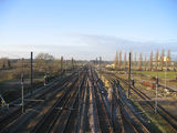
Tallington is located on the main A16 road (for Market Deeping) which runs between Stamford and Spalding. To the west is Uffington. Tallington has a busy level crossing over the East Coast Main Line. There was once a Tallington railway station, but it is now closed. Since the 1930s there has been a plan for a Tallington bypass and bridge over the railway; even though the village ended up making concrete bridges for many UK motorways (including much of the Yorkshire section of the M62), there has never been a bridge made for the village.[1] Dow Mac even offered to donate a bridge to the village.
From the East Coast Main Line south-east of the village, the parish boundary follows the River Welland to the west, it meets Uffington and crosses the A16 a half-mile west of the village at the point where the pylons cross the road, then skirts the edge of Casewick Park. It crosses the ECML a half-mile north of the village, and meets Barholm and Stowe. It skirts the northern edge of Barholm Lodge, across the north section of Tallington Lakes and meets West Deeping at King Street. It follows King Street southwards to the A16, which it follows to the west, around the western edge of West Deeping, to the River Welland, north of Lolham Mill, where it meets the City of Peterborough and the parish of Bainton.
History
At the Tallington Lakes Leisure Park, made from gravel pits, is a dry ski slope and water activities with a campsite. The parish church is dedicated to St Lawrence and is in the Uffington Group of churches. The village pub is the Whistle Stop next to the railway, formerly known as the Kesteven Arms. The village station closed in 1959. The River Welland passes across the south of the village. A hundred metres further south is the Lincolnshire county boundary.
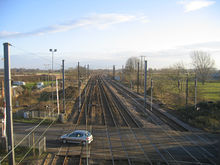
Dow-Mac
 East Coast Main Line looking north, with the former Dow-Mac works on the right
Tallington Lakes are situated directly east of the former Dow-Mac concrete works, and are formed from its gravel pits. Dow-Mac, on Barholm Road, was formed by Harry Dowsett, who lived in Greatford Hall, in 1943 as Dowsett Engineering Construction, later working with Mackay. It made concrete railway sleepers during the war, and later motorway concrete pillars and beams. Prestressed concrete was first made by Dow Mac (Products) Ltd in Tallington.
Dowsett Engineering Construction built junctions 5 to 7 of the M11, and hence was made of concrete. They also built junctions 25 to 27 of the M62 in West Yorkshire, including the Chain Bar Interchange and the M606 in December 1972, and junctions 27 to 29 in February 1971, junctions 29 to 31 including the Lofthouse Interchange in August 1974, and junctions 31 to 33 in March 1974; the A1(M) Darlington bypass in 1965; from the M6 to junction 2 of the M69 in 1977; junctions 31 to 34 of the M1 in July 1967; junctions 2 to 4 of the M42 in June 1986; junctions 2 to 4 of the M18 in February 1979; the A64 Malton bypass[2] in 1979; and junctions 9 to 13 of the M20 in 1981.
The site is now known as Tarmac Precast Concrete.
Local Administration
Tallington is currently served by a Parish Council and two District Councillors and a County Councillor. The two currently elected District Councillors are Kelham Cooke (Con) and Rosemary Woolley (Con)
Notable residents
- Jacqueline Knox, a physiotherapist to the British rowing team[3]
References
 Level crossing looking south from the footbridge
External links
- Tallington Lakes
- Information about the village
- Uffington Group
- Parish council
- Tallington Bypass/Level Crossing Enhancement
- Tarmac Building Products
News items
Settlements on the River Welland, Source – Wash Market Harborough · Ketton · Stamford · The Deepings (Market Deeping, Deeping St. James, Deeping Gate) · Crowland · SpaldingCategories:- Villages in Lincolnshire
- Civil parishes in Lincolnshire
- South Kesteven
- Concrete pioneers


Wikimedia Foundation. 2010.