- Kitwe
Infobox Settlement
official_name = PAGENAME
other_name =
native_name =
nickname =
settlement_type =
motto =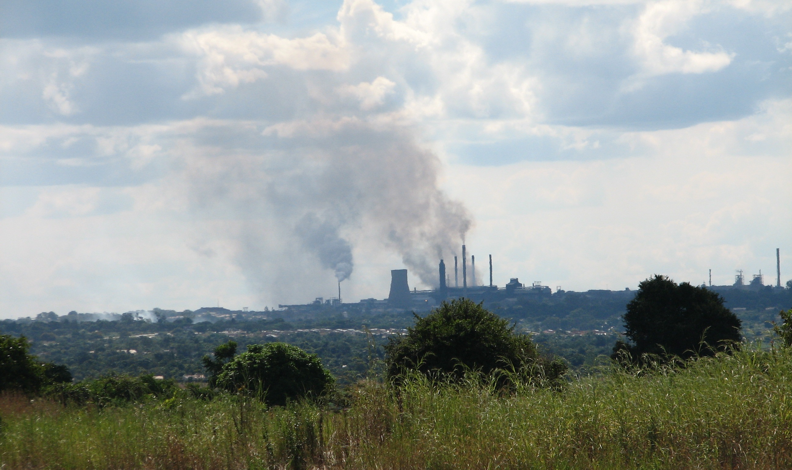
imagesize = 300px
image_caption =
flag_size =
image_
seal_size =
image_shield =
shield_size =
image_blank_emblem =
blank_emblem_type =
blank_emblem_size =
mapsize =
map_caption =
mapsize1 =
map_caption1 =
image_dot_
dot_mapsize =
dot_map_caption =
dot_x = |dot_y =
pushpin_
pushpin_label_position =bottom
pushpin_map_caption =Location in Zambia
subdivision_type = Country
subdivision_name =
subdivision_type1 = Admin. division
subdivision_name1 =Copperbelt Province
subdivision_type2 =
subdivision_name2 =
subdivision_type3 =
subdivision_name3 =
subdivision_type4 =
subdivision_name4 =
government_footnotes =
government_type =
leader_title =
leader_name =
leader_title1 =
leader_name1 =
leader_title2 =
leader_name2 =
leader_title3 =
leader_name3 =
leader_title4 =
leader_name4 =
established_title =
established_date =
established_title2 =
established_date2 =
established_title3 =
established_date3 =
area_magnitude =
unit_pref =Imperial
area_footnotes =
area_total_km2 =
area_land_km2 =
area_water_km2 =
area_total_sq_mi =
area_land_sq_mi =
area_water_sq_mi =
area_water_percent =
area_urban_km2 =
area_urban_sq_mi =
area_metro_km2 =
area_metro_sq_mi =
area_blank1_title =
area_blank1_km2 =
area_blank1_sq_mi =
population_as_of =2000
population_footnotes =
population_note =
population_total = 363,734
population_density_km2 =
population_density_sq_mi =
population_metro =
population_density_metro_km2 =
population_density_metro_sq_mi =
population_urban =
population_density_urban_km2 =
population_density_urban_sq_mi =
population_blank1_title =Ethnicities
population_blank1 =
population_blank2_title =Religions
population_blank2 =
population_density_blank1_km2 =
population_density_blank1_sq_mi =
timezone =
utc_offset =
timezone_DST =
utc_offset_DST =
latd=12 |latm=49 |lats= |latNS=S
longd=28 |longm=12 |longs= |longEW=E
elevation_footnotes =
elevation_m =
elevation_ft =
postal_code_type =
postal_code =
area_code =
blank_name =
blank_info =
blank1_name =
blank1_info =
website =
footnotes =Kitwe is the third-largest city in
Zambia , with a population of 363,734 (2000 census). It is in the centre of theCopperbelt , Zambia's copper-mining region, in the ProvinceCamerapix: "Spectrum Guide to Zambia." Camerapix International Publishing, Nairobi, 1996.] of that name, with a complex of mines on its north-western and western edges. [http://earth.google.com Google Earth] accessed 2007.]Kitwe includes a number of townships and suburbs including Nkana East, Nkana West, Mindolo and Garneton. The city is sometimes referred to as Kitwe-Nkana. As well as the mines, the city has light industrial areas manufacturing building materials, furniture and consumer goods.
Kitwe-Nkana Mines
There are two main underground mines in Kitwe, Nkana in the south-west and Mindolo in the north-west. Nkana includes a concentrator, smelter and refinery, as well as a cobalt plant producing about 1800 tonnes per year, operated by Mopani Copper Mines plc. [ [http://ebizguides.com/guides/sponsors/alone.php?sponsor=336&country=15 Ebizguides website: "Zambia: Mopani Copper Mines"] Website accessed 18 March 2007.] There are extensive mine
tailings around both mines, and two small tailings dams right in the city centre. There are also small-scale emerald mines in the area.See
Copperbelt Province for the history of the copper-mining industry.Communications
Kitwe lies at the end of
Zambia Railways ' passenger services from Livingstone,Lusaka andNdola , [ [http://www.seat61.com/Zambia.htm#Livingstone%20-%20Lusaka "Seat61 website"] retrieved 2 June 2007, says information was correct in November 2006.] but freight lines continue to the mining towns to the north-west. The main highway through the Copperbelt runs south-east to north-west through the city, toNdola (as a freeway) in the south-east, and toNchanga ,Chingola andChililabombwe in the north-west. A laterite road goes west toKasempa .Terracarta/International Travel Maps, Vancouver Canada: "Zambia, 2nd edition", 2000]Southdowns Airport, Kitwe lies about 12 km south-west of the town but does not currently receive scheduled services. The airport was closed down for repair in 2005, and are not expected to open anymore.Ndola Airport is 60 km south-east.Education
A
student andteacher exchange programme was introduced in 1999 with teacher exchange visits byKingsmead Community School inWiveliscombe ,England with two Kitwe schools -Helen Kaunda High School andMukuba High School . This started a series of partnerships between Zambian and UK schools and there are now over 30 such school partnerships. Students from Kingsmead paid a visit to the Kitwe schools in 2005. [ [http://www.times.co.zm/news/viewnews.cgi?category=8&id=1123874431 "Zambia/UK student partnerships fostering multi-cultural relations"] , Gethsemane Mwizabi,Times of Zambia , 2005]Features of Kitwe
* Obote Ave
Market : arts and crafts stalls, including copper craft items.
* [http://www.cbu.edu.zm Copperbelt University]
* Mindolo Ecumenical Centre
* Kitwe Central Hospital
*Nkana FC
*Power Dynamos FC
*Kitwe United Football Club
*Arthur Davies Stadium
*Chisokone Market
*Nkana Mine Around Kitwe
The landscape around Kitwe is an attractive mix of gently undulating woodland,
dambos , farmland and rivers such as theKafue River flowing along Kitwe's eastern and southern edges.
* Mindolo Dam 7km west of the city centre towardsKalulushi has a boating club,swimming pool and bar.* Mwekwera Falls 9 km south east just off the Kitwe-Ndola freeway, with a small lake and fish farms. The falls are small but scenic with an attractive pool below.
* Chembe Bird Sanctuary 20 km east on the Kasempa Road has a small lake surrounded by woodland and is excellent for birdwatching, fishing, camping and picnics. The shady lake shore has campsites with a communal amenities block, firewood, and water. Boats are available for hire and fishing is permitted. It is run by the [http://www.wcsz.org.zm Wildlife and Environmental Conservation Society of Zambia] .ister cities
Kitwe's has four sister cities:
* -Baia Mare ,Romania * - Bor,
Serbia * -
Sheffield ,England * - Detroit,
Michigan ,United States References
External links
* [http://www.greatnorthroad.org/maps/nkana_kitwe/ Historical, vector-based map of Nkana-Kitwe, 1961]

Wikimedia Foundation. 2010.