- Pennsylvania Route 112
-
PA Route 112
Route information Length: 4.75 mi[1] (7.64 km) Existed: 1928 – 1946 Major junctions South end:  US 322 in Markham
North end:  PA 926 in Tanguy
Location Counties: Delaware, Chester Highway system Roads in Pennsylvania
Interstate • US • State • Legislative←  US 111
PA 113  →
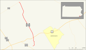
→Pennsylvania Route 112 (known formerly by the Pennsylvania Department of Highways as SR 0112) was a 4.75-mile (7.64 km) long state highway located in Delaware and Chester counties in Pennsylvania. Running along current day Cheyney Road, PA 112 began at an intersection with U.S. Route 1 in Markham, headed northward, and terminated at an intersection with Pennsylvania Route 926 in the community of Tanguy.
PA 112 was assigned in the commonwealth's numbering of state highways in 1928. The route remained intact for thirteen years, when, in 1941, the highway was extended southward to U.S. Route 322 south of Markham. The route remained for another five years, when the route was removed from the state highway system completely.
Contents
Route description
Pennsylvania Route 112 began at an intersection with U.S. Route 322 (now an intersection with Concord Road) in the community of Markham. The route progressed northward as Cheyney Road, intersecting with several local roads before passing the Newlin Grist Mill Park near the intersection with U.S. Route 1 (the Baltimore Pike). After that intersection, PA 112 turned to the northeast, passing through Markham before leaving the community.[1]
PA 112 went through the community of Thornton, intersecting with Glen Mills Road. At an intersection with Thornton Road, the route crossed into Chester County, but left quickly for Delaware County again. North of the community of Cheyney, Route 112 crossed the county line, passing the Cheyney University of Pennsylvania before the terminus at an intersection with Pennsylvania Route 926 in the Chester County community of Tanguy.[1]
History
Route 112 was first assigned in the 1928 state numbering of state highways in Pennsylvania. The route, when originally assigned, did start in Markham, but at an intersection with U.S. Route 1.[2] The route's northern terminus remained the same in the route's entire lifetime. In 1941, the southern terminus was adjusted from the intersection with U.S. Route 1 (the Baltimore Pike) to an intersection with U.S. Route 322 near Markham.[3] Although they made the adjustment, PA 112 ended up becoming one of the many routes decommissioned in 1946, when the commonwealth of Pennsylvania removed several hundred miles from their system.[4] The designation has not been re-used since the 1946 removal.[5]
Major intersections
County Location Mile[1][6] Destinations Notes Delaware Markham 0.00 US 322Southern terminus of PA 112. Now an intersection with Concord Road.  US 1 (Baltimore Pike)
Former southern terminus of PA 112. Chester Tanguy 4.75 PA 926 (East Street Road)Northern terminus of PA 112. 1.000 mi = 1.609 km; 1.000 km = 0.621 mi See also
- Pennsylvania Route 12 (1920s)
References
- ^ a b c d Yahoo! Inc. Yahoo! Maps – overview map of former PA 112 (Map). Cartography by NAVTEQ. http://maps.yahoo.com/#mvt=m&lat=39.935237&lon=-75.520449&zoom=15&q1=39.879076%2C-75.506888&q2=39.891095%2C-75.505986&q3=39.903606%2C-75.511651&q4=39.913219%2C-75.518475&q5=39.929875%2C-75.523367&q6=39.94083%2C-75.530234. Retrieved June 5, 2009.
- ^ Pennsylvania Department of Highways (1928). Map Showing Pennsylvania State Highways (Map).
- ^ Pennsylvania Department of Highways (1941). Pennsylvania Official Road Map (Map).
- ^ Pennsylvania Department of Highways (1946). Pennsylvania Official Road Map (Map).
- ^ Pennsylvania Department of Transportation (2009). Pennsylvania (Map). Cartography by Pennsylvania Department of Transportation.
- ^ DeLorme (2007). Street Atlas 2007 (Map). Cartography by DeLorme Incorporated.
Categories:- Former state highways in Pennsylvania
- Transportation in Delaware County, Pennsylvania
- Transportation in Chester County, Pennsylvania


Wikimedia Foundation. 2010.