- Ocean Breeze Park, Florida
-
Ocean Breeze Park, Florida — Town — Old Town Hall, now the office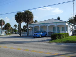 Location in Martin County and the state of Florida
Coordinates: 27°14′26″N 80°13′28″W / 27.24056°N 80.22444°WCoordinates: 27°14′26″N 80°13′28″W / 27.24056°N 80.22444°W Country  United States
State  Florida
County Martin Founded 1938 Incorporated 1953 Government – Type Town – Mayor Seat Vacant Area – Total 0.2 sq mi (0.5 km2) – Land 0.2 sq mi (0.4 km2) – Water 0 sq mi (0.1 km2) Elevation 7 ft (2 m) Population (2000) – Total 463 – Density 2,315/sq mi (926/km2) Time zone Eastern (EST) (UTC-5) – Summer (DST) EDT (UTC-4) FIPS code 12-50900[1] GNIS feature ID 0288033[2] 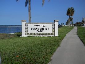 Welcome marker on northern town limits on Indian River Drive
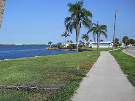 The riverside portion of the town from the north
Ocean Breeze Park is a town on the Indian River in Martin County, Florida, United States. It and Briny Breezes in Palm Beach County are the only two towns in Florida in which all residents live in a mobile home park bearing the name of the town. The population was 463 at the 2000 census. As of 2004, the population recorded by the U.S. Census Bureau is 459.[1] The population figures do not include the many part-time winter residents from other places. The town is an enclave within the census designated place of Jensen Beach
Ocean Breeze Park is part of the Port St. Lucie Metropolitan Statistical Area, which includes all of Martin and St. Lucie counties.
Contents
Main areas in town
The town consists of 3 parts:
- 1.A large mobile home park called Ocean Breeze Park, where all of the town's residents live. It is located east of the FEC tracks, a block or so south of Jensen Beach Boulevard and west of the Indian River. The mobile home park consists of 3 major areas:
- A.The small waterfront area lying east of Indian River Drive;
- B.The modern addition area lying north of Key Lime Drive; and
- C.The large original park area lying South of Key Lime Drive with smaller lots, older homes, narrower streets and more residents than the other two;
- 2.A large shopping center called Ocean Breeze Plaza, which is anchored by a Publix super market and is located on the south side of Jensen beach Boulevard just west of the FEC tracks; and
- 3.A large undeveloped area of high sugar sand dunes lying west of the FEC tracks and south of the shopping center.
All roads within the town are private except for Ocean Breeze Drive which runs east-west and Indian River Drive, CR 707, which runs north-south. The residents of the town are among the few in the area who still receive mail delivered to their front doors instead of curbside. The town is served by the Jensen Beach post office (ZIP 34957).
Geography
Ocean Breeze Park is located at 27°14′26″N 80°13′28″W / 27.240532°N 80.224358°W.[3]
According to the United States Census Bureau, the town has a total area of 0.2 square miles (0.52 km2), of which, 0.2 square miles (0.52 km2) of it is land and 0.04 square miles (0.10 km2) of it (19.05%) is water.
Ocean Breeze Park is bounded on the east by the Indian River and on the south, west and north by the unincorporated community of Jensen Beach, Florida. Since Ocean Breeze Park does not have its own post office, its mailing address is Jensen Beach, Florida.
Demographics
As of the census[1] of 2000, there were 463 people, 335 households, and 107 families residing in the town. The population density was 2,706.5 people per square mile (1,051.6/km²). There were 579 housing units at an average density of 3,384.6 per square mile (1,315.0/km²). The racial makeup of the town was 98.49% White, 1.08% African American, and 0.43% from two or more races. Hispanic or Latino of any race were 1.08% of the population.
There were 335 households out of which 0.3% had children under the age of 18 living with them, 26.9% were married couples living together, 4.8% had a female householder with no husband present, and 67.8% were non-families. 63.6% of all households were made up of individuals and 43.9% had someone living alone who was 65 years of age or older. The average household size was 1.38 and the average family size was 2.05.
In the town the population was spread out with 0.2% under the age of 18, 0.4% from 18 to 24, 5.4% from 25 to 44, 27.4% from 45 to 64, and 66.5% who were 65 years of age or older. The median age was 70 years. For every 100 females there were 83.0 males. For every 100 females age 18 and over, there were 83.3 males.
The median income for a household in the town was $15,709, and the median income for a family was $27,813. Males had a median income of $17,083 versus $25,208 for females. The per capita income for the town was $19,802, which ranks it 418 out of 887 towns in Florida.[4] About 14.6% of families and 15.3% of the population were below the poverty line, including none of those under age 18 and 12.7% of those age 65 or over.
Town government
The town is governed by a town council which meets on the second Monday of each month at 10:30 A.M. in Hoke Hall. Dorothy Geeben, aged 101, was Mayor of the town but does not have a vote on the council. When she was re-elected in 2004 at age 96, the national media dubbed her the nation's oldest living mayor.[5] Mayor Geeben died on January 11, 2010 at the age of 101 just short of her 102nd birthday.[6]
References
- ^ a b "American FactFinder". United States Census Bureau. http://factfinder.census.gov. Retrieved 2008-01-31.
- ^ "US Board on Geographic Names". United States Geological Survey. 2007-10-25. http://geonames.usgs.gov. Retrieved 2008-01-31.
- ^ "US Gazetteer files: 2010, 2000, and 1990". United States Census Bureau. 2011-02-12. http://www.census.gov/geo/www/gazetteer/gazette.html. Retrieved 2011-04-23.
- ^ Florida locations by per capita income
- ^ 96-year-old is likely nation's oldest mayor - U.S. news - MSNBC.com
- ^ http://www.wptv.com/content/news/martin/story/Dorothy-geeben-oldest-active-mayor-dies-wptv/18LOhVTyCUqVYprO5gvaMQ.cspx
External links
- Homeowner's Sites
- 1.http://www.oceanbreezepark.org/
- 2.http://www.oceanbreezehomeowners.com/
- 3.http://www.oceanbreezetreasurecoast.org/
- Official Town Site
- http://townofoceanbreezepark.org/
- Mayor Green passes on
Municipalities and communities of Martin County, Florida City 
Towns Jupiter Island | Ocean Breeze Park | Sewall's Point
CDPs Unincorporated
communityCategories:- Towns in Martin County, Florida
- Port St. Lucie metropolitan area
- Jensen Beach, Florida


Wikimedia Foundation. 2010.