- Carlsbad, California
-
Carlsbad — City — City of Carlsbad 
SealLocation of Carlsbad within San Diego County, California.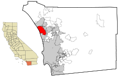 Location in the United States
 Carlsbad
Coordinates: 33°7′19″N 117°17′49″W / 33.12194°N 117.29694°WCoordinates: 33°7′19″N 117°17′49″W / 33.12194°N 117.29694°W Country  United States
State  California
County San Diego Government – Mayor Claude "Bud" Lewis Area[1] – Total 39.110 sq mi (101.295 km2) – Land 37.722 sq mi (97.699 km2) – Water 1.388 sq mi (3.596 km2) 3.55% Elevation 52 ft (16 m) Population (2010) – Total 105,328 – Rank 5th in San Diego County
59th in California
256th in the United States– Density 2,693.1/sq mi (1,039.8/km2) Time zone PST (UTC-8) – Summer (DST) PDT (UTC-7) ZIP code 92008, 92009, 92010, 92011 Area code(s) 760, 442 (overlaid) FIPS code 06-11194 GNIS feature ID 1660437 Website carlsbadca.gov Carlsbad is a coastal resort city lying along the Pacific Ocean in San Diego's North County region of Southern California. Carlsbad is located 87 miles (140 km) south of Los Angeles and 35 miles (56 km) north of downtown San Diego. High property values, very high median family incomes, and high education levels have made Carlsbad one of the wealthiest communities in California and in the United States. The majority of San Diego County's top twenty-five employers have their locations closer to Carlsbad than San Diego.[2] A coastal location, thriving commercial sector, and award-winning school district all contribute to the high standard of living in the area. It is one of the highest-income places in the United States. The city is mainly known for shopping, tourism, a booming high-tech industry, and resort living. The population was 105,328 at the 2010 census.
The city has drafted ordinances protecting sensitive wildlife habitat, becoming one of the first municipalities in the state of California to do so. The city has also pledged to protect a specified amount of land within the city limits from development of any kind and spends significant funds to restore habitats destroyed by newer development projects.
Contents
History
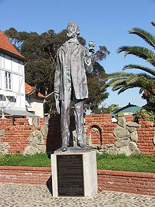 Statue of John Frazier
Carlsbad's history begins with the Luiseño people who located one of their villages, Palamai, near what is today Agua Hedionda Lagoon. In the 1880s a former sailor named John Frazier dug a well in the area. He began offering his water at the train station and soon the whistle-stop became known as Frazier's Station. A test done on a second fresh-water well discovered the water to be chemically similar to the one found in some of the most renowned spas in the world, such as the Carlsbad Spa in Bohemia, or Karlovy Lazne in the city of Karlovy Vary in the Czech Republic.[citation needed]
To take advantage of the find, the Carlsbad Land and Mineral Water Company was formed by a German-born merchant from the Midwest named Gerhard Schutte together with Samuel Church Smith, D.D.Wadsworth and Henry Nelson. The naming of the town followed soon after, along with a major marketing campaign to attract visitors. The area experienced a period of growth, with homes and businesses sprouting up in the 1880s. Agricultural development of citrus fruits, avocados and olives soon changed the landscape. By the end of 1887, land prices fell throughout San Diego County. However, the community survived on the back of its fertile agricultural lands.
The site of John Frazier's original well can still be found at Alt Karlsbad, a replica of a German Hanseatic house, located on Carlsbad Boulevard.
The world's first skateboard park,[citation needed] Carlsbad Skatepark, was built here in March 1976. It was located on the grounds of Carlsbad Raceway and was designed and built by inventors Jack Graham and John O'Malley.
Geography
According to the United States Census Bureau, the city has a total area of 39.1 square miles (101 km2) of which 37.7 square miles (98 km2) are land and 1.4 square miles (3.6 km2) are (3.55%) water, the majority of which is contained within three lagoons and one lake.
The northern area of the city is considered to be part of the tri-city area, which consists of northern Carlsbad, southern Oceanside and western Vista.
Most of the current city area, including many of its boasted attractions, has been annexed from neighboring unincorporated areas since the 1970s.
Climate
Carlsbad has a Subtropical-Mediterranean Climate, similar to many coastal areas of California.
Climate data for Carlsbad, California Month Jan Feb Mar Apr May Jun Jul Aug Sep Oct Nov Dec Year Record high °F (°C) 87
(31)90
(32)90
(32)93
(34)89
(32)93
(34)103
(39)94
(34)108
(42)105
(41)100
(38)90
(32)108
(42)Average high °F (°C) 64
(18)64
(18)64
(18)65
(18)66
(19)69
(21)72
(22)74
(23)73
(23)71
(22)68
(20)65
(18)67.9 Average low °F (°C) 45
(7)47
(8)48
(9)51
(11)56
(13)60
(16)63
(17)64
(18)61
(16)56
(13)49
(9)45
(7)53.8 Record low °F (°C) 20
(−7)28
(−2)34
(1)33
(1)38
(3)43
(6)44
(7)47
(8)43
(6)36
(2)29
(−2)27
(−3)20
(−7)Precipitation inches (mm) 2.42
(61.5)2.23
(56.6)2.11
(53.6)0.92
(23.4)0.23
(5.8)0.09
(2.3)0.02
(0.5)0.13
(3.3)0.29
(7.4)0.43
(10.9)0.92
(23.4)1.34
(34)11.13
(282.7)Source: [3] Carlsbad neighborhoods
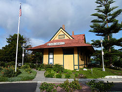 The Old Santa Fe Depot, built in 1907, is a local landmark listed on the National Register of Historic Places and currently houses the city's Visitor's Information Center.
Northwest quadrant
Hosp Grove, a grove of trees relatively untouched by development and now designated by the city for recreational use, is located in the northwest quadrant, along with the Buena Vista and Agua Hedionda Lagoons. The Buena Vista Lagoon is the subject of controversy.[clarification needed]
The Barrio
The area near downtown Carlsbad, "bordered by Carlsbad Village Drive to the north, Tamarack Avenue to the south, Interstate 5 to the east and the railroad tracks to the west," was settled by Latinos in the early 20th century.[4] It is the site of the Centro de Aprendizaje, a Spanish division of the Carlsbad City Library.[5]
Northeast quadrant
The quadrant consists mostly of single family homes, with larger lots found in the older area known as Chestnut Hills.
Demographics
Historical populations Census Pop. %± 1950 4,383 — 1960 9,253 111.1% 1970 14,944 61.5% 1980 35,490 137.5% 1990 63,126 77.9% 2000 78,247 24.0% 2010 105,328 34.6% 2010
The 2010 United States Census[6] reported that Carlsbad had a population of 105,328. The population density was 2,693.1 people per square mile (1,039.8/km²). The racial makeup of Carlsbad was 87,205 (82.8%) White, 1,379 (1.3%) African American, 514 (0.5%) Native American, 7,460 (7.1%) Asian, 198 (0.2%) Pacific Islander, 4,189 (4.0%) from other races, and 4,383 (4.2%) from two or more races. Hispanic or Latino of any race were 13,988 persons (13.3%).
The Census reported that 104,413 people (99.1% of the population) lived in households, 459 (0.4%) lived in non-institutionalized group quarters, and 456 (0.4%) were institutionalized.
There were 41,345 households, out of which 14,079 (34.1%) had children under the age of 18 living in them, 22,657 (54.8%) were opposite-sex married couples living together, 3,792 (9.2%) had a female householder with no husband present, 1,519 (3.7%) had a male householder with no wife present. There were 2,038 (4.9%) unmarried opposite-sex partnerships, and 295 (0.7%) same-sex married couples or partnerships. 9,890 households (23.9%) were made up of individuals and 3,800 (9.2%) had someone living alone who was 65 years of age or older. The average household size was 2.53. There were 27,968 families (67.6% of all households); the average family size was 3.03.
The population was spread out with 25,366 people (24.1%) under the age of 18, 6,718 people (6.4%) aged 18 to 24, 28,073 people (26.7%) aged 25 to 44, 30,373 people (28.8%) aged 45 to 64, and 14,798 people (14.0%) who were 65 years of age or older. The median age was 40.4 years. For every 100 females there were 95.6 males. For every 100 females age 18 and over, there were 92.5 males.
There were 44,673 housing units at an average density of 1,142.2 per square mile (441.0/km²), of which 26,808 (64.8%) were owner-occupied, and 14,537 (35.2%) were occupied by renters. The homeowner vacancy rate was 1.4%; the rental vacancy rate was 4.6%. 69,855 people (66.3% of the population) lived in owner-occupied housing units and 34,558 people (32.8%) lived in rental housing units.
2000
As of the census of 2000, there were 78,247 people, 31,521 households, and 20,898 families residing in the city.[7] The population density was 2,090.2 people per square mile (806.9/km²). There were 33,798 housing units at an average density of 902.8 per square mile (348.5/km²). The racial makeup of the city was 86.6% White, 1.0% African American, 0.4% Native American, 4.2% Asian, 0.2% Pacific Islander, 4.7% from other races, and 3.0% from two or more races. Hispanic or Latino of any race were 11.7% of the population.
There were 31,521 households out of which 30.7% contained children under the age of 18, 54.3% were married couples living together, 8.6% had a female householder with no husband present, and 33.7% were non-families. 24.8% of all households were made up of single individuals and 8.2% had someone living alone who was 65 years of age or older. The mean household size was 2.46 and the mean family size was 2.96.
23.3% of residents were under the age of 18, 6.2% from 18 to 24, 31.9% from 25 to 44, 24.6% from 45 to 64, and 14.0% 65 years of age or older. The median age was 39 years. For every 100 females there were 95.8 males. Among those 18 and older, there were 92.8 males for every 100 females.
According to a 2007 Census estimate, the median income for a household in the city was $79,444, and the median income for a family was $100,932.[8] Males had a median income of $54,826 versus $39,415 for females. The per capita income for the city was $34,863. About 3.4% of families and 5.9% of the population fell below the poverty line, including 7.3% of those under age 18 and 3.6% of those age 65 or over.
Current estimates
According to estimates made by the CBRE Demographic Report in 2005, an estimated average household income for Carlsbad neighborhoods (92008, 92009, 92011) were $106,459, $108,364, and $111,483, respectively.
Politics
In the state legislature Carlsbad is located in the 38th Senate District, represented by Republican Mark Wyland, and in the 74th Assembly District, represented by Republican Martin Garrick. Federally, Carlsbad is located in California's 50th congressional district, which has a Cook PVI of R +3[9] and is represented by Republican Brian Bilbray.
Carlsbad voters in 2008 approved making Carlsbad a charter city. City government is led by an elected mayor and four council members, elected at large. Mayor Claude "Bud" Lewis has been mayor since 1986 and on the council since 1970. Carlsbad has no term limits. Other council members that year include Matt Hall, Mark Packard, Ann Kulchin and Julie Nygaard, a former councilwoman who was appointed in 2007 to replace Norine Sigafoose, who resigned, for personal reasons, with 18 months left in her term. Nygaard was appointed with the promise that she would not seek re-election. In the fall of 2008 Kulchin announced she would seek an eighth four-year term. Also in the race, for Kulchin's seat and the open seat vacated by Nygaard, were publisher and veteran journalist Thomas K. Arnold, police sergeant Keith Blackburn, and print shop owner Farrah Douglas, a city planning commissioner. They were joined by college student Evan Delaney Rodgers and retired Marine Glenn Bernard. Bernard has run for office in Carlsbad before. With support from the public labor unions, Kulchin and Blackburn won. Blackburn set a new record for campaign expenditures, pouring nearly $100,000 into his successful campaign. Douglas finished third, and Arnold came in fourth. Glenn and Rodgers came in fifth and last, respectively. It should be noted that Rodgers vowed to spend less than $100 of her own money on the campaign and succeeded. Both Glenn and Rodgers vowed right from the start not to use plastic campaign signs for ecological reasons.[citation needed]
With Mayor Bud Lewis, who has been in office since 1986, stepping down at the completion of his latest four-year term in 2010, Carlsbad witnessed a heated battle pitting Matt Hall, a longtime city councilman, against fellow city councilman Keith Blackburn. Hall made pension reform the core issue of his campaign while Blackburn was supported by both the police and firefighter unions. Hall ultimately won by a significant margin, 46.5% to 40.7%, even though Blackburn had far more campaign signs and mailers, many of them funded by the unions.[10] The council race for 2010 was won by incumbent Mark Packard[11] and planning commissioner Farrah Douglas, who had run in 2008 but narrowly lost. Jon Wantz, a newcomer to Carlsbad politics, and frequent council candidate Bill Jubb also ran.[12]
Economy
The GEO Group maintains its Western Regional Office in Carlsbad.[13]
Top employers
According to the city's 2010 Comprehensive Annual Financial Report,[14] the top manufacturing employers in the city are:
# Employer # of Employees 1 Life Technologies 3,988 2 TaylorMade-adidas 2,075 3 Callaway 1,637 4 Asymtek 671 5 Zimmer Dental 643 6 Genoptix 537 7 Crestone Group Baking Cos. 530 8 Alphatec Spine 504 9 Titleist 307 10 Emerson Network Power 299 The top non-manufacturing employers in the city are:
# Employer # of Employees 1 ViaSat 1,940 2 Legoland California 1,022 3 Carlsbad Unified School District 983 4 La Costa Resort and Spa 838 5 Park Hyatt Resort Aviara 823 6 City of Carlsbad 713 7 24-Hour Fitness 536 8 Prescription Solutions 516 9 Gemological Institute of America 496 10 Toyota Carlsbad/Scion Carlsbad 357 Notable corporate headquarters
- 24 Hour Fitness, Fitness Centers
- Aptera Motors, 300mpg vehicle startup
- Arkeia Software, network backup solutions
- Atticus Clothing, Apparel
- AutoClaims Direct, Insurance claims technology firm
- California Pacific Airlines, a planned airline[15]
- Callaway Golf Company, Golf equipment and apparel manufacturer
- Cobra Golf, Golf equipment and apparel manufacturer
- Fallen Footwear, Shoe company
- Gemological Institute of America, Headquarters
- Hay House, new age publisher
- Hot Dog on a Stick, restaurants
- Islands Fine Burgers & Drinks, restaurant
- Jazzercise, International dance fitness program
- Jenny Craig, Inc., Weight management
- K2 Sports, Winter sports equipment
- Life Technologies, Biotechnology
- Macbeth Footwear, apparel
- MaxLinear, Semiconductors
- No Fear, apparel
- Osiris Shoes, Shoe company
- Razer USA Ltd, Computer peripherals manufacturer
- Reef, Apparel
- Rubio's Fresh Mexican Grill, Quick serve restaurants
- Sierra Wireless, Research and development office, CDMA and EVDO products
- TaylorMade-adidas Golf Company, Golf equipment and apparel manufacturer
- Upper Deck, Sports and entertainment trading card manufacturer[16][17]
- ViaSat, Inc, Satellite communications
Schools
- School Districts
- Carlsbad Unified School District
- Encinitas Union School District-for Elementary schools in South Carlsbad
- San Dieguito Union High School District-for Junior High and High schools in South Carlsbad
- San Marcos Unified School District-for schools in southeast Carlsbad
- Public High
- Carlsbad High School
- La Costa Canyon High School
- Public Intermediate
- Public Interlevel
- Public Elementary
- Aviara Oaks Elementary School
- Buena Vista Elementary School
- Calavera Hills Elementary School
- Carlsbad Seaside Academy (K-6 Alternative Education)
- Hope Elementary School
- Jefferson Elementary School
- Kelly Elementary School
- Magnolia Elementary School
- Pacific Rim Elementary School
- Poinsettia Elementary School
- El Camino Creek Elementary School
- La Costa Heights Elementary School
- Mission Estancia Elementary School
- Olivenhain Pioneer Elementary School
- Private Schools
- Army and Navy Academy: Military Prep
- Pacific Ridge School
- St. Patrick School
- Montessori Arts and Sciences School
- Beautiful Saviour Lutheran Elementary School
- The Academy by the Sea: Camp Pacific
- Palisades Point Christian Academy
Public libraries
Sister cities
Carlsbad has two sister cities, as designated by Sister Cities International:
 Futtsu, Japan
 Karlovy Vary, Czech Republic
Attractions
- Maritime
- Agua Hedionda Lagoon
- Batiquitos Lagoon
- Buena Vista Lagoon
- Carlsbad Lagoon
Notable former and current residents
- Frank Alesia, character actor and television director[18]
- Marcus Allen, college and professional football star
- Michael Austinmoore, of alternative rock band VAST
- Brian P. Bilbray, U.S. Congressman
- Ron Blair, bassist for Tom Petty and the Heartbreakers
- Adam Brody, American film and television actor; played Seth Cohen on The O.C.
- Chad Butler, drummer for Switchfoot
- Leo Carrillo, actor, cartoonist, conservationist and preservationist, and owner of Leo Carrillo Ranch in Carlsbad[19]
- Brandon Chillar, linebacker for the Green Bay Packers
- Jim Cochran, pioneering organic strawberry farmer.
- Jonathan Compas, center for Tampa Bay Buccaneers
- S.E. Cupp, journalist and political commentator
- David Díaz,Caldecott winning illustrator/author
- Rob Dyrdek, professional skateboarder and television personality lived in Carlsbad during the filming of Rob and Big
- Jon Foreman, lead singer of alternative band Switchfoot
- Tim Foreman, brother of Jon Foreman and bassist for Switchfoot
- Ryan Gallant, professional skateboarder
- LeRoy Grannis,[20] surfing photographer; LeRoy Grannis: Surf Photography of the 1960s and 1970s
- Ryan Guy, football player for St. Patricks Athletic in the Republic of Ireland.
- Tony Hawk: former resident; now lives in nearby Encinitas.
- Michellie Jones, Pro Triathlete, 2006 Ironman World Champion, 2000 Olympic Silver Medalist
- Rod Laver, former world #1 Australian tennis player, retired in La Costa.[21]
- Sal Masekela,[22] son of musician Hugh Masekela. CHS graduate. TV host for Winter X Games on ESPN.
- Gregory R Nelson Sr., cofounder of DonJoy, Inc., present chairman and CEO of United Orthopedic Group
- Emily O'Brien,[23] The Young and the Restless actress; 2003 graduate CHS
- Ron Packard, U.S. Congressman
- Jean Peters, movie actress and wife of Howard Hughes
- John Pugsley, libertarian political activist
- Bridget Regan, actress known for her role as Kahlan Amnell on Legend of the Seeker
- Boris Said, NASCAR Sprint Cup Series race car driver
- Brian Simo, NASCAR Nationwide Series race car driver
- Staciana Stitts, 2000 Summer Olympics Gold Medalist swimmer; graduate CHS
- Victor Villaseñor, bestselling author
- Sadie West, pornographic actress, 2010 AVN Award nominee – Best New Starlet Award
- Shaun White, professional snowboarder, skateboarder, and Winter Olympics Gold Medalist; current resident of nearby Rancho Santa Fe.
References
- ^ U.S. Census
- ^ California Pacific Airlines. "San Diego North Means Business". http://www.flycpair.com/landingpage/business.htm. Retrieved 2011-02-26.
- ^ Average Weather for Carlsbad, CA
- ^ New effort begins on planning for Carlsbad's Barrio area, in North County Times, retrieved 2011-10-19.
- ^ Las Bibliotecas de Carlsbad, retrieved 2011-10-19.
- ^ All data are derived from the United States Census Bureau reports from the 2010 United States Census, and are accessible on-line here. The data on unmarried partnerships and same-sex married couples are from the Census report DEC_10_SF1_PCT15. All other housing and population data are from Census report DEC_10_DP_DPDP1. Both reports are viewable online or downloadable in a zip file containing a comma-delimited data file. The area data, from which densities are calculated, are available on-line here. Percentage totals may not add to 100% due to rounding. The Census Bureau defines families as a household containing one or more people related to the householder by birth, opposite-sex marriage, or adoption. People living in group quarters are tabulated by the Census Bureau as neither owners nor renters. For further details, see the text files accompanying the data files containing the Census reports mentioned above.
- ^ "American FactFinder". United States Census Bureau. http://factfinder.census.gov. Retrieved 2008-01-31.
- ^ http://factfinder.census.gov/servlet/STTable?_bm=y&-context=st&-qr_name=ACS_2007_1YR_G00_S1901&-ds_name=ACS_2007_1YR_G00_&-CONTEXT=st&-tree_id=307&-redoLog=false&-_caller=geoselect&-geo_id=16000US0611194&-format=&-_lang=en factfinder.census.gov
- ^ "Will Gerrymandered Districts Stem the Wave of Voter Unrest?". Campaign Legal Center Blog. http://www.clcblog.org/blog_item-85.html. Retrieved 2008-02-10.
- ^ CARLSBAD: City's labor groups have nearly $90,000
- ^ Mark Packard: I am happy to announce...
- ^ Notice of Nominees for Public Office
- ^ "Western Regional Office." GEO Group. Retrieved on July 19, 2010.
- ^ City of Carlsbad, California Comprehensive Annual Financial Report, for the Year ended June 30, 2010
- ^ "Contact." California Pacific Airlines. Retrieved on May 15, 2010.
- ^ "F.A.Q.s." Upper Deck Company. Retrieved on April 17, 2011. "Our corporate headquarters is located in the beautiful, seaside community of Carlsbad in San Diego's North County."
- ^ "FAQs." Upper Deck Company. Retrieved on April 17, 2011. "5909 Sea Otter Place Carlsbad, CA 92010"
- ^ Barnes, Mike (2011-03-04). "Character actor, director Frank Alesia dies". Hollywood Reporter (Reuters Canada). http://ca.reuters.com/article/entertainmentNews/idCATRE72369L20110304. Retrieved 2011-03-14.
- ^ Leo Carrillo Ranch
- ^ Smithsonian Magazine | Arts & Culture | Endless Summers
- ^ Paris, Jay (2005-06-17). "Federer is Laver's Wimbledon favorite". North County Times. http://www.nctimes.com/articles/2005/06/18/sports/professional/61705210207.txt. Retrieved 2007-09-25.
- ^ SignOnSanDiego.com > Sports - Winter X marks surfer's spot
- ^ Today’s Local News » Restless no more
External links
- City of Carlsbad · Official website.
- Carlsbad City Library
- Carlsbad Chamber of Commerce
- Carlsbad Historical Society
Mayors of cities with populations exceeding 100,000 in California - Antonio Villaraigosa
(Los Angeles) - Jerry Sanders
(San Diego) - Chuck Reed
(San Jose) - Edwin M. Lee
(San Francisco) - Ashley Swearengin
(Fresno) - Kevin Johnson
(Sacramento) - Bob Foster
(Long Beach) - Jean Quan
(Oakland) - Harvey Hall
(Bakersfield) - Tom Tait
(Anaheim) - Miguel A. Pulido
(Santa Ana)
- Ronald O. Loveridge
(Riverside) - Ann Johnston
(Stockton) - Cheryl Cox
(Chula Vista) - Bob Wasserman
(Fremont) - Sukhee Kang
(Irvine) - Pat Morris
(San Bernardino) - Jim Ridenour
(Modesto) - Thomas E. Holden
(Oxnard) - Acquanetta Warren
(Fontana) - William H. Batey II
(Moreno Valley)^ - John Drayman
(Glendale)
- Joe Carchio
(Huntington Beach)^ - Bob Kellar
(Santa Clarita)^ - William Dalton
(Garden Grove) - Susan Gorin
(Santa Rosa)^ - Jim Wood
(Oceanside) - Donald Kurth
(Rancho Cucamonga) - Paul S. Leon
(Ontario) - R. Rex Parris
(Lancaster) - Pat Hume
(Elk Grove) - James C. Ledford Jr.
(Palmdale) - Stan Skipworth
(Corona)^
- Dennis Donohue
(Salinas) - Elliot Rothman
(Pomona) - Frank Scotto
(Torrance) - Michael Sweeney
(Hayward) - Sam Abed
(Escondido) - Tony Spitaleri
(Sunnyvale) - Bill Bogaard
(Pasadena) - Carolyn Cavecche
(Orange) - F. Richard Jones
(Fullerton)^ - Jacqui Irwin
(Thousand Oaks)^ - Jesus Gamboa
(Visalia)
- Paul Miller
(Simi Valley) - William D. Shinn
(Concord)^ - Gina Garbolino
(Roseville) - Jamie L. Matthews
(Santa Clara) - Osby Davis
(Vallejo) - Rudy Cabriales
(Victorville) - Ernest Gutierrez
(El Monte) - Tom Bates
(Berkeley) - Rick Trejo
(Downey)^ - Eric R. Bever
(Costa Mesa)^ - James T. Butts, Jr.
(Inglewood)
 ^Mayor selected from city council
Other states: AL • AK • AZ • AR • CA • CO • CT • DE • FL • GA • HI • ID • IL • IN • IA • KS • KY • LA • ME • MD • MA • MI • MN • MS • MO • MT • NE • NV • NH • NJ • NM • NY • NC • ND • OH • OK • OR • PA • RI • SC • SD • TN • TX • UT • VT • VA • WA • WV • WI • WYCategories:- San Diego metropolitan area
- Cities in Southern California
- Cities in San Diego County, California
- Populated coastal places in California
- Populated places established in 1952
- Incorporated cities and towns in California


Wikimedia Foundation. 2010.