- Martinsville Township, Clark County, Illinois
-
Martinsville Township — Township — Location in Clark County Clark County's location in Illinois
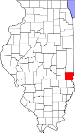
Coordinates: 39°19′21″N 87°51′22″W / 39.3225°N 87.85611°WCoordinates: 39°19′21″N 87°51′22″W / 39.3225°N 87.85611°W Country United States State Illinois County Clark Established November 7, 1854 Area - Total 41.82 sq mi (108.33 km2) - Land 41.68 sq mi (107.95 km2) - Water 0.15 sq mi (0.38 km2) 0.35% Elevation 643 ft (196 m) Population (2000) - Total 1,688 - Density 40.5/sq mi (15.6/km2) Time zone CST (UTC-6) - Summer (DST) CDT (UTC-5) ZIP code 62442 GNIS feature ID 0429333 Martinsville Township is one of fifteen townships in Clark County, Illinois, USA. As of the 2000 census, its population was 1,688[1].
Contents
Geography
According to the United States Census Bureau, Martinsville Township covers an area of 41.82 square miles (108.3 km2); of this, 0.15 square miles (0.39 km2) or 0.35 percent is water.
Cities, towns, villages
- Martinsville (vast majority)
Unincorporated towns
- Weir
(This list is based on USGS data and may include former settlements.)
Cemeteries
The township contains these six cemeteries: Island Grove, Kettering, Lincoln, Mount Pleasant, Baird and Rupp.
Major highways
 Interstate 70
 US Route 40
School districts
- Casey-Westfield Community Unit School District 4c
- Martinsville Community Unit School District 3c
Political districts
- Illinois' 15th congressional district
- State House District 109
- State Senate District 55
References
- "Martinsville Township, Clark County, Illinois". Geographic Names Information System, U.S. Geological Survey. http://geonames.usgs.gov/pls/gnispublic/f?p=gnispq:3:::NO::P3_FID:0429333. Retrieved 2010-01-10.
- United States Census Bureau 2007 TIGER/Line Shapefiles
- United States National Atlas
External links

Parker Township Dolson Township Auburn Township Casey Township 
Anderson Township  Martinsville Township

Johnson Township Orange Township Melrose Township Municipalities and communities of Clark County, Illinois Cities Casey‡ | Marshall | Martinsville

Town Townships Unincorporated
communitiesAdenmoor | Allright | Castle Fin | Choctaw | Clark Center | Clarksville | Cleone | Darwin | Dennison | Doyles | Ernst | Farrington | Golf Lakes | Hogue Town | Livingston | McKeen | Melrose | Moonshine | Moriah | Neadmore | Oak Point | Oakcrest | Oilfield | Orange | Patton‡ | Snyder | Walnut Prairie | Weaver | Weir | West Union | York
Ghost town Griffin
Footnotes ‡This populated place also has portions in an adjacent county or counties
Categories:- Townships in Clark County, Illinois


Wikimedia Foundation. 2010.