- Döbeln
-
Döbeln 

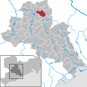
 DöbelnLocation of the town of Döbeln within Mittelsachsen district
Coordinates 51°7′10″N 13°6′46″E / 51.11944°N 13.11278°ECoordinates: 51°7′10″N 13°6′46″E / 51.11944°N 13.11278°E Administration Country Germany State Saxony Admin. region Chemnitz District Mittelsachsen Town subdivisions 19 Mayor Hans-Joachim Egerer (CDU) Basic statistics Area 39.47 km2 (15.24 sq mi) Elevation 159-262 m Population 21,297 (31 December 2010)[1] - Density 540 /km2 (1,397 /sq mi) Other information Time zone CET/CEST (UTC+1/+2) Licence plate FG Postal code 04720 Area code 03431 Website www.doebeln.de Döbeln is a town in the Free State of Saxony, Germany, part of the Mittelsachsen district, located at both banks of the river Freiberger Mulde.
Contents
History
It was founded in the 10th century, the first written proof of its existence dates back to the year 981.[2]
- Around the year 1220 Döbeln got the official status of a city.
- 1293: the Nicolai church was first mentioned.
- 1296: castle and town are occupied by Adolf of Nassau.
- 1330: at 25.03. the monastery buildings completed.
- 1333: a serious fire incinerated the entire town.
- 1360: Knight Ulmann of Staupitz builds castle Reichenstein.
- 1429: looting of the town and destruction of the castle by the Hussites.
- 1450: Döbeln is raided by the Bohemians, severely damaging the castle. After that, the castle declined in its importance. In 1567 it was mentioned as "deserted palace" and afterwards only used as a quarry.
- 1637: plundered by the Swedes
- 1730: Another serious blaze hit the city. As a result, the remains of the castle were used as building material for rebuilding. In this fire, 266 homeowners and 400 renters lost their home.
- During the Seven Years War, there was a battle between the Prussians and the Austrians. On 12 May 1762 the troops of Prince Henry of Prussia defeated the Austrian troops and took prisoners including the commander General von Zedtwitz.
- 1754-1810 is Döbeln garrison of infantry regiment Lubomirsky.
- 1847 Döbeln was connected to the railway from Riesa. In 1857 the line extended to Chemnitz. In 1868 the Dresden-Döbeln-Leipzig line is opened.
- 1945 the city is occupied by the Soviet Army without a single shot being fired.
Traffic
Döbeln Hauptbahnhof is on the Borsdorf–Coswig and Riesa–Chemnitz lines.
It has two connections to the A14 motorway (Autobahn).
Döbeln has the last remaining horse-drawn tram line in Germany, in the form of the Döbeln Tramway. This line originally ran from 1892 to 1926, and was reopened in 2007.
International relations
Döbeln is twinned with:
See also
- Georg Carl von Döbeln, a Swedish military officer.
External links
- Döbeln-Wiki (German)
References
- Notes
- ^ "Bevölkerung des Freistaates Sachsen jeweils am Monatsende ausgewählter Berichtsmonate nach Gemeinden" (in German). Statistisches Landesamt des Freistaates Sachsen. 31 December 2010. http://www.statistik.sachsen.de/download/010_GB-Bev/Bev_Gemeinde.pdf.
- ^ MGH DD Otto II. 195. Digitalisat: http://mdz10.bib-bvb.de/~db/bsb00000443/images/index.html?id=00000443&no=1&seite=225
- ^ http://www.informationen-reise.de/deutschland-reisefuehrer/sachsen/doebeln/ [Döbeln official statistics] | accessdate=2009-12-29
Altmittweida | Augustusburg | Bobritzsch | Bockelwitz | Brand-Erbisdorf | Burgstädt | Claußnitz | Döbeln | Dorfchemnitz | Eppendorf | Erlau | Flöha | Frankenberg | Frankenstein | Frauenstein | Freiberg | Geringswalde | Großhartmannsdorf | Großschirma | Großweitzschen | Hainichen | Halsbrücke | Hartha | Hartmannsdorf | Hilbersdorf | Königsfeld | Königshain-Wiederau | Kriebstein | Leisnig | Leubsdorf | Lichtenau | Lichtenberg | Lunzenau | Mittweida | Mochau | Mühlau | Mulda | Neuhausen | Niederstriegis | Niederwiesa | Oberschöna | Oederan | Ostrau | Penig | Rechenberg-Bienenmühle | Reinsberg | Rochlitz | Rossau | Roßwein | Sayda | Seelitz | Striegistal | Taura | Waldheim | Wechselburg | Weißenborn | Zettlitz | Ziegra-Knobelsdorf | Zschaitz-Ottewig Categories:
- Towns in Saxony
- Saxony geography stubs

Wikimedia Foundation. 2010.