- Lexington Bridge (Mississippi River)
Infobox_Bridge
bridge_name= Lexington Bridge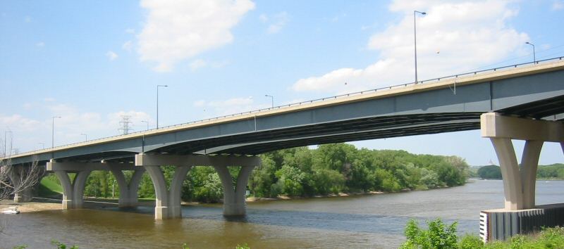
caption=The Lexington Bridge as viewed from the south, looking toward downtown St. Paul.
official_name=
crosses=Mississippi River
carries=Interstate 35E
locale=St. Paul, Minnesota
design=Plate girder bridge
mainspan=
length=1406 feet (428.6 m)
width=110 feet (33.6 m)
below=61 feet (18.5 m)
open=2004
maint=Minnesota Department of Transportation
id=62912
coordinates= coord|44|54|16|N|93|08|20|W|region:US_type:landmark
lat=
long=
clearance=
traffic=81000
closed=
toll=
map_cue=
map_
map_text=
map_width=Lexington Bridge is a
plate girder bridge that spans theMississippi River betweenSt. Paul, Minnesota andLilydale, Minnesota . It was built in 2004 by theMinnesota Department of Transportation .The original Lexington Bridge was built in 1965 as part of the proposed construction of Interstate 35E. However, the bridge did not see much use for a while, because I-35E was not completed between Lilydale and Burnsville until the mid-1980s. Construction of I-35E between
Minnesota State Highway 5 , just north of the bridge, andInterstate 94 in downtown St. Paul was not finished until the early 1990s. The increase in traffic caused the old bridge to deteriorate faster than expected. As a result of deterioration, and a need to carry more traffic, the old bridge was replaced. The staging of this construction project was notable for keeping four lanes of traffic open during the process. A new span was built on the west side of the bridge, and then traffic was detoured to the new southbound span and the old southbound span. The old northbound span was demolished, and a new northbound span was built. When this was completed, the old southbound span was demolished, and the inner two lanes of the new bridge were completed.The bridge has an anti-icing system that sprays
potassium acetate onto the bridge surface to prevent frost and ice formation in inclement weather. This is part of a test to see if measured application of chemicals can prolong the life of a structure, as compared to the usual liberal application ofsodium chloride salt.ee also
*
List of crossings of the Upper Mississippi River References
*cite web
last = Weeks
first = John
authorlink =
coauthors =
year = 2005
url = http://www.johnweeks.com/bridges/pages/ms08.html
title = Lexington Bridge, St. Paul, MN
format =
work = The Bridges Of Minneapolis And St. Paul
publisher =
accessdate = 2006-05-25
accessyear =
*cite web
year = 2006
url = http://nationalbridges.com
title = National Bridge Inventory
accessdate = 2006-05-25
accessyear =
*cite web|year=2005|url=http://www.dot.state.mn.us/metro/news/05/07/13i35e.html|title=Work Begins Tomorrow on New Anti-icing System on Interstate 35E Lexington Bridge Spanning the Mississippi River in St. Paul|publisher=Minnesota Department of Transportation|accessdate=2006-05-25Crossings navbox
structure = Bridges
place =Mississippi River
bridge = Lexington Bridge
bridge signs =
upstream =Fort Road Bridge
upstream signs =
downstream =Omaha Road Bridge Number 15
downstream signs =
Wikimedia Foundation. 2010.