- Indiana State Road 168
Infobox road
state=IN
type=IN
route=168
alternate_name=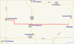
length_mi=16.5
length_round=1
length_ref= [http://illi-indi.com/EndsPage.php?id=1168§ion=1 Indiana Highway Ends - SR 168] ]
established=
direction_a=West
starting_terminus=
junction=
direction_b=East
ending_terminus=
counties=Gibson
previous_type=IN
previous_route=167
next_type=IN
next_route=203State Road 168 is an 18-mile long east-west two-lane highway running from State Road 65 in Owensville, through the north side of Fort Branch, to State Road 57 in Mackey. It runs around 3 miles north and parallel to its parent highway, State Road 68. State Road 168 is entirely within Gibson County, spanning Barton, Montgomery, and Union Townships.
State Road 168 currently only intersects with
U.S. Route 41 ; however, it will also intersect withInterstate 69 when the first section ofInterstate 69 'sTier 1 project is completed, which is expected to happen in 2011.Major intersections
Source: INDOT Roadway Referencing System [ [http://www.in.gov/indot/3361.htm INDOT Roadway Referencing System] ] INint
county=Gibson
cspan=3
mile=0.00
road=
location=Owensville
notes=SR 168 beginsINint
mile=7.77
road=
location=Fort BranchINint
mile=17.17
road=
location=Mackey
notes=SR 168 endsReferences

Wikimedia Foundation. 2010.