- Metedeconk River
-
Coordinates: 40°03′08″N 74°05′13″W / 40.05222°N 74.08694°W
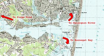 Map of lower Metedeconk River. Grids are 1 km square.
The Metedeconk River (pronounced /məˈtiːdəkʌŋk/) of southeastern New Jersey flows from its North Branch (20 miles/32 km long) and its South Branch (15 miles/24 km long) to their confluence at Forge Pond, where the river then widens (up to just over 1 mile/1.6 km) and flows southeast for 6 miles/9.7 km into the Barnegat Bay. It contains both fresh and salt-water portions.
Like many area streets, waterways and towns, Metedeconk is the original word or phrase used by the pre-European peoples of the area, the Lenape.
Contents
Geographic relation to nearby water features
At its most eastern face the river meets Island Beach, a populated but narrow strip (less than 1 mile (1.6 km wide) of New Jersey separating the Metedeconk from a direct connection with the Atlantic Ocean. Here, the river joins the Barnegat Bay to the south and the narrow, man-made Point Pleasant Canal to the north. This canal provides a convenient connection to the Manasquan River, which would otherwise be completely separated from the Metedeconk by about 3 miles (4.8 km) of land. The Manasquan River is directly connected to the Atlantic Ocean, as is Barnegat Bay.
Interactions with ocean waters
The river is of the floodplain type and is tidal, being indirectly connected to the Atlantic Ocean through the Barnegat Bay and the Manasquan River. The Metedeconk's main oceanic interactions are through the Manasquan, via the Point Pleasant Canal. In fact, before the canal was opened in 1926, the Metedeconk and the upper part of the Barnegat Bay were mainly fresh water environments and non-tidal. Today, due to ocean tides, the waters of the Bay and the Manasquan are both inlets and outlets of the Metedeconk.
Since the canal, the waters of the lower Metedeconk have been brackish to salty and the ecology of the area has changed considerably. A visual indication of the river's connection to the ocean is the cream to brown colored foam that sometimes collects where the Metedeconk's waves beat the sandy shores or manmade bulkheads. This foam consists of the microscopic organic material that naturally builds up in the presence of aquatic life; the process of filtering organics from water through wave-like action has been mechanized in most aquariums and is known there as foam fractionating.
Notable areas
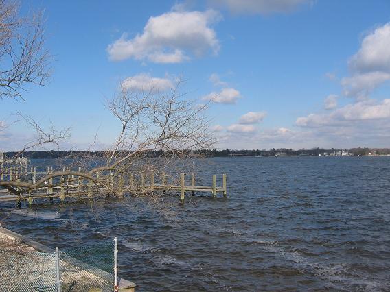
 Lower section of the Metedeconk in February.
The river west of Forge Pond (where it forks into North and South Branches) is known as the upper section, while the river east of Forge Pond is known as the lower section. The upper section is popular with paddle boaters. The lower section, being deeper, wider and wavier, is more popular with sailboats and powerboats.
A notable section of the lower Metedeconk is Windward Beach, a small beach sanctioned for public recreation. On the upper Metedeconk, the river flows through the fresh-water Lake Shenandoah, where a popular county park holds great attraction.
Importance to local communities
The Metedeconk River is important to local wildlife and the surrounding human populations, providing a place of recreation as it winds through the towns of Brick, Freehold, Howell, Jackson, Wall, Lakewood and Millstone. It is the primary source of drinking water for Brick, Point Pleasant Beach and Point Pleasant Borough. As such, it was classified as a Category 1 (C1) River, the highest level of protection offered rivers by the state of New Jersey.
Wildlife
With both fresh-water and tidal wetland portions, the Metedeconk supports an extremely diverse range of wildlife. Wild rice grows along the banks along some portions of the Metedeconk. Bald eagles have been sighted there, and ospreys nest atop nearby trees and industrial towers and come to the river to fish. Sections of the river and surrounding estuary habitat are protected as parts of New Jersey’s extensive Edwin B. Forsythe National Wildlife Refuge, because of the river’s great significance to migratory birds and waterfowl.
Mammals of the Metedeconk include those typically found at New Jersey rivers, such as river otters and beavers. Aquatic life includes many species of fish and jellyfish, including one species whose bodies are about two-inches long and appear clear in daylight, but glow blue by night.
Tributaries
See also
- List of New Jersey rivers
External links
Categories:- Place names in New Jersey of Native American origin
- Rivers of New Jersey
- Geography of Ocean County, New Jersey

Wikimedia Foundation. 2010.