- Dingolshausen
-
Dingolshausen 

 DingolshausenLocation of Dingolshausen within Schweinfurt district
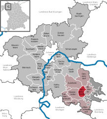
Coordinates 49°54′N 10°24′E / 49.9°N 10.4°ECoordinates: 49°54′N 10°24′E / 49.9°N 10.4°E Administration Country Germany State Bavaria Admin. region Lower Franconia District Schweinfurt Municipal assoc. Gerolzhofen Mayor Lothar Zachmann Basic statistics Area 10.23 km2 (3.95 sq mi) Elevation 270 m (886 ft) Population 1,256 (31 December 2010)[1] - Density 123 /km2 (318 /sq mi) Other information Time zone CET/CEST (UTC+1/+2) Licence plate SW Postal code 97497 Area code 09382 Website www.dingolshausen.de Dingolshausen is a municipality in the district of Schweinfurt in Bavaria, Germany. Dingolshausen is a Village in the district of Schweinfurt in Bavaria, Germany. Located at the foot of the Steigerwald (forest) and in the valley of a creek named the Volkach. Dingolshausen is mostly famous for their wineries. Kohler is know throughout Germany and the rest of the world.
Coat of Arms: The coat of arms (Wappen) was given to Dingolshausen in the year 1561. It shows two grapes as a symbol of the winemakers (Winzwer).
History: - 1165 first documented as Dingolshausens, which was later in the year of 1243 ruled by The Bishopric of Würzburg (hochstift Wuerzburg).
Web-links: Commons: Dingolshausen (http://commons.wikimedia.org/wiki/Category:Dingolshausen?uselang=de) Collection of pictures and videos of the village.
Bergrheinfeld · Dingolshausen · Dittelbrunn · Donnersdorf · Euerbach · Frankenwinheim · Geldersheim · Gerolzhofen · Gochsheim · Grafenrheinfeld · Grettstadt · Kolitzheim · Lülsfeld · Michelau im Steigerwald · Niederwerrn · Oberschwarzach · Poppenhausen · Röthlein · Schonungen · Schwanfeld · Schwebheim · Sennfeld · Stadtlauringen · Sulzheim · Üchtelhausen · Waigolshausen · Wasserlosen · Werneck · Wipfeld

References
- ^ "Fortschreibung des Bevölkerungsstandes" (in German). Bayerisches Landesamt für Statistik und Datenverarbeitung. 31 December 2010. https://www.statistikdaten.bayern.de/genesis/online?language=de&sequenz=tabelleErgebnis&selectionname=12411-009r&sachmerkmal=QUASTI&sachschluessel=SQUART04&startjahr=2010&endjahr=2010.
Categories:- Municipalities in Bavaria
- Schweinfurt district
- Lower Franconia geography stubs


Wikimedia Foundation. 2010.