- Gränichen
Infobox Swiss town
subject_name = Gränichen
municipality_name = Gränichen
municipality_type = municipality
imagepath_coa = Graenichen-blason.png|pixel_coa=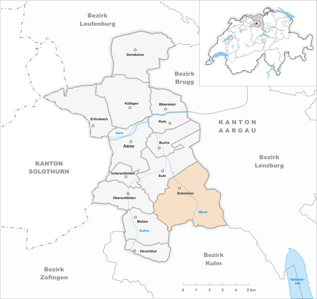
languages = German
canton = Aargau
iso-code-region = CH-AG
district = Aarau
lat_d=47|lat_m=21|lat_NS=N|long_d=8|long_m=06|long_EW=E
postal_code = 5722
municipality_code =
area = 17.21
elevation = 410|elevation_description= |highest_m=615|highest=Pfendel|lowest_m=402|lowest=Wyna
population = 6458|populationof=December 2007
website = www.graenichen.ch
mayor = Hans Fellmann|mayor_asof=|mayor_party=
mayor_title = |list_of_mayors =
places = Gränichen, Rütihof, Bleien, Refental
demonym =
neighboring_municipalities=Hunzenschwil ,Muhen ,Oberentfelden ,Schafisheim , Seon, Suhr,Teufenthal ,Unterkulm
twintowns = |Gränichen is a municipality in the district of Aarau of the canton of
Aargau inSwitzerland .Geography
The river
Wyna flows north at first and heads northwest thereafter. The valley has an average width of about 500 meters.On both sides of the valley there are steep hills with tributary valleys and small high plateaus. The landscape reminds of theTafeljura , even though - geographically and geologically speaking - Gränichen lies in the Midland of Switzerland.The hills on the left side of the valley are (from north to south): Manzenberg (524 m), Wällenen (559 m), Moosberg (550 m), Heidberg (566 m) and Pfendel (615 m). These are foothills of the Schornig (596 m), which marks the transition to the valley of the river Suhre. The hills on the right side of the valley are called Fuden (570 m), Räckholderen (566 m), Breitenberg (551 m) and Surberg (607 m). In front of the Breitenberg is the Schulthess (513 m) which has almost the shape of an ellipsis. The Dossen (532 m) und the high plateau of the
Liebegg are foothills of the Surberg.Near the southern border, at an average distance of two kilometers, there are three hamlets, which also belong to the municipality of Gränichen: Rütihof (585 m) on Moorbergs, Bleien (430 m) and Refental (490 m) between Breitenberg, Dossen and Surberg.
The municipal area of the village is 1721 hectars, out of which 981 hectars are forest and 226 hectars are overbuilt. The highest point is at 615 m. above main sea level on the 'Pfendel', the lowest point is at 402 m. where the river wyna leaves the village.
The seven neighbourvillages are Suhr in the nordwest,
Hunzenschwil in the north,Schafisheim in the northeast,Seon, Switzerland in the east,Teufenthal in the south,Unterkulm in the south, Muhen in the southwest and Hirschthal in the west.History
History's first mention of Gränichen was around 1184 under the name of "Cranechon". However, archaeological discoveries dating from the
Neolithic , as well as the remains of a Celtic castle, show that the area around Gränichen has been settled for quite some time.In the 12th century Gränichen belonged to the
monastery of Engelberg and later came under the reign of theHabsburg s, who passed the government of the village to the Lords of the Castle ofLiebegg . After 1415, Gränichen belonged toBern .The construction of the
Wynentalbahn railway in 1904 promoted the settlement of local industries.Points of interest
The castle of Liebegg resides on a hill close to the border to
Teufenthal , about three kilometers south-south-east of the village center. The Castle, which dates from the 11th century, is nowadays used as a center for culture, meetings and congresses.Near the village center one finds the "Chornhaus", which, built in 1695, looks very similar to a small castle, because of its tower. Until 1798 it served as a granary and was thereafter used by the municipal administration department for over a century. Since the new parish hall was completed in 1995 it contains a small village museum.
The Reformed Church was build from 1661 to 1663 on the site where the previous church had collapsed. It is one of the main works of Protestant church building in the canton of Aargau, and is listed as a heritage site of national significance. [
Swiss inventory of cultural property of national and regional significance (1995), p. 38.]Population
On December 31 of 2004, the municipality of Gränichen had 6366 inhabitants. The census records of 2000 showed that 59,2% were
Reformed , 22,4% wereCatholic , 4,3% wereMoslem , 1,1% are Christian-Orthodox and 1,0% belonged to a differentreligion . 90,2% indicated German as their main language, 4,1% were Italian, 1,5% were Albanian, 1,1% Serbocroatian and 0,7% Turkish speaking.Authorities
The municipal assembly (Gemeindeversammlung), is the law-making body (legislature). The
executive authority is the municipal council (Gemeinderat). The members of the council are elected by the assembly according to the principle of majority. They stay in office for a duration of four years. The councils task is to lead and represent the municipality. In order to do so, he takes care of the decisions of the assembly and the assignements imposed by the canton and the federal government.The five municipal councils are:
*Hans Fellmann,Mayor
*Ulrich Widmer, Vice-Mayor
*Judith Baumann
*Hans Hotz
*Marlise WidmerThe
district court ofAarau is responsible for matters ofcivil right .Economy
There are around 2300 Jobs in Gränichen, 5% of which are in the
agricultural sector , 56% work in the localindustries and 39% in the services trade. One of the largest bakeries in Switzerland ( [http://www.jowa.ch Jowa] ) is located in Gränichen. In addition, there is also a company which fabricates heaters ( [http://export.zehnder-online.com/ Zehnder] ), a gravel plant and several other smaller businesses.Transport
Gränichen lies on the connecting road from
Aarau viaBeromünster toLuzern . The town is also connected to Seon in the Valley of Lakes. The local public rail service (AAR-Bahn), which goes fromAarau through the valley of theWyna up toMenziken , has four stations: Töndler, Gränichen-Dorf, Oberdorf and Bleien. The rails of the public transport were right next to the main street, until they were rebuilt along the riverWyna in 1985.Education
There are five
kindergarten s as well as threeelementary school s. Furthermore, there is a center for secondary education covering "Realschule", "Sekundarschule" and "Bezirksschule" levels. The closest gymnasium is inAarau . As of 2004, the number of students is 894. Aside from the Castle of Liebegg, there is also an agricultural school.Further reading
*"Gränicher Dorfgeschichte", by Markus Widmer-Dean, 2003
*"Gib uns auch morgen unser tägliches Brot, die wechselvolle Lebensgeschichte des Gränicher Kornhauses", by Franz Kretz, 1995References
External links
* [http://www.graenichen.ch Official webpage of Gränichen]
* [http://www.schloss-liebegg.ch Castle of Liebegg]
* [http://www.liebegg.ch Agricultural School]
* [http://www.aar.ch AAR Bus und Bahn (public transport)]
*HDS|1625
Wikimedia Foundation. 2010.