- Newtown railway station, Sydney
-
 Newtown
Inner West Line South Line Station code NTN Suburb Newtown Street(s) King Street Distance from Central Station 3.10 km Altitude (above sea level) ? m Types of stopping trains Suburban all stations
Suburban Limited StopsNumber of platforms 2 Number of tracks 6 Platform arrangement 1 island Type of station Ground Ticket barriers Not currently due to access upgrade Transfers available Bus Disabled access 
No Station facilities Link Newtown railway station is a located on the Main Suburban railway line in the inner western Sydney suburb of Newtown. It is served by trains of CityRail's Inner West and South lines. It is served by an average of 4550 daily weekday passengers.[1]
The station features a single platform on the 'Local' pair of tracks (the "Inner West Line"), with trains to the city leaving from the north side and trains from the city arriving on the south side. It is located in a small cutting and must be accessed via stairs leading down from King St.
The island platform is rather narrow and there are no Easy Access facilities. In its 2007 budget, the NSW State Government committed to funding for an upgrade to the station[2] including the installation of lifts, new stairways and canopies, toilets and lighting. Plans for redevelopment were not lodged however until August 2009. The proposed upgrade will consist of a new ticket office, refurbishment of the heritage building, a new public entrance leading to a new concourse and three new shops at the site of the access to the former tram depot adjacent to the station.[1]
The former Newtown Tram Depot lies disused to the south of the station.
Contents
History
 The station entrance
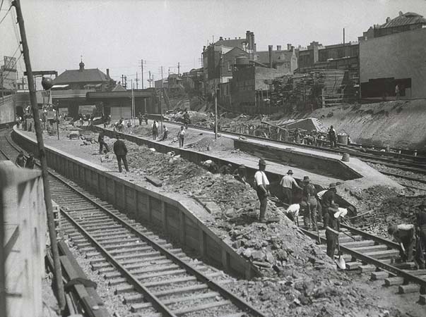
A station opened at Newtown in 1855 with the opening of the Main Suburban Railway Line.[3] This original station was to the west of King St, about where the former Crago's Flour Mills now stand.[4] Mortuary facilities were provided from 1875.[4] The line through Newtown was quadruplicated in 1892,[5] and a new station was built at the present location.[4] This station contained two side platforms and an island platform in the centre.[4] The site of the original station became a goods yard.[4] The track through Newtown was sextuplicated in 1927 in association with electrification works.[4][6] This meant that the northern side platform and the island platform on the middle pair of tracks were taken out of use and demolished.[4] The southern side platform was modified and converted into the current island platform.[4]
Platforms and services
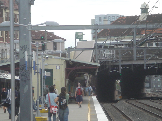
 Construction of the new concourse in October 2011.
The station is served by two to four trains per hour each way, with additional trains during weekday peak hours. During off-peak hours two of these four train services towards Regents Park terminate in Ashfield.
Platform Line Stopping Pattern Notes 
Inner West Line all stations services to Central and the City Circle. South Line all stations and limited stops services to Central and the City Circle. Only a small number of South line trains stop at Newtown, mainly during peak hour. 
Inner West Line all stations services to Ashfield, Strathfield, Lidcombe, Cabramatta and Liverpool via Regents Park. South Line all stations and limited stops services to Glenfield and Campbelltown via Granville. Only a small number of South line trains stop at Newtown, mainly during peak hour. Transport links
Sydney Buses runs nine routes via Newtown station:
- Route 352 - weekdays (Monday to Friday) daytime services - between Bondi Junction Interchange and Marrickville Metro Shopping Centre
- Route 355 - between Bondi Junction Interchange and Marrickville Metro Shopping Centre
- Route 370 - between Leichhardt Marketplace and Coogee
- Route 422 - between Circular Quay and Kogarah
- Route 423 - between Circular Quay and Kingsgrove
- Route L23 - Weekdays(Monday to Friday) peak hour limited stops services - between Circular Quay and Kingsgrove
- Route 426 - between Circular Quay and Dulwich Hill
- Route 428 - between Circular Quay and Canterbury
- Route L28 - weekdays (Monday to Friday) peak hour limited stops services - between Circular Quay and Canterbury.
- metrobus M30 - between Sydenham and Spit Junction via Wynyard station
NightRide runs three routes via Newtown station:
- Route N10 - between Sutherland station and City (Town Hall)
- Route N30 - between Macarthur station and City (Town Hall)
- Route N40 - between East Hills station and City (Town Hall)
Galleries
- During Easy Access upgrade
-

Platform 1
-

Platform 2
-

Looking to Sydney CBD from end of platforms
-

Ticket Office windows
-

Easy access upgrade sign
- Historical gallery
-

The original station prior to quadruplication, c. 1880
-

The second station prior to sextuplication, 1914
-

The second station prior to sextuplication, 1914
-

Sextuplication works, 1927
-

Sextuplication works, 1927
-

The platforms in 2006
-

Stairs to the concourse, 2009
-

Area between the ticket office and the stairs, 2009
Neighbouring stations
Preceding station CityRail Following station towards CampbelltownSouth Line Redferntowards Centraltowards LiverpoolInner West Line Macdonaldtowntowards CentralReferences
- ^ a b Sansom, M. Going Up. Inner West courier, 13 August 2009.
- ^ NSW State Budget, Infrastructure Statement 2007-08
- ^ "Main South Line". Nswrail.net. http://www.nswrail.net/lines/show.php?name=NSW:main_south.
- ^ a b c d e f g h Janette Pelosi. "Transport in Newtown". City of Sydney. http://cityofsydney.nsw.gov.au/newtownproject/essays/jp/JanettePelosiChap3.html.
- ^ N.S.W. Railway Passenger Services 1880-1905 Australian Railway History, Vol 56, No. 810, April 2005 p141
- ^ Sydney Electric Trains from 1926-1960, Australian Railway Historical Society Bulletin, April 2001 p128.
Inner West Line - Central
- Museum
- St James
- Circular Quay
- Wynyard
- Town Hall
- Central
- Redfern
- Macdonaldtown
- Newtown
- Stanmore
- Petersham
- Lewisham
- Summer Hill
- Ashfield
- Croydon
- Burwood
- Strathfield
- Homebush
- Flemington
- Lidcombe
- Berala
- Regents Park
- Sefton
- Chester Hill
- Leightonfield
- Villawood
- Carramar
- Cabramatta
- Warwick Farm
- Liverpool
South Line - Central
- Museum
- St James
- Circular Quay
- Wynyard
- Town Hall
- Central
- Redfern
- Newtown
- Ashfield
- Burwood
- Strathfield
- Flemington
- Lidcombe
- Auburn
- Clyde
- Granville
- Merrylands
- Guildford
- Yennora
- Fairfield
- Canley Vale
- Cabramatta
- Warwick Farm
- Liverpool
- Casula
- Glenfield
- Macquarie Fields
- Ingleburn
- Minto
- Leumeah
- Campbelltown
(stations in italics are under planning or under construction)CityRail Lines Suburban - Eastern Suburbs & Illawarra
- Bankstown
- Inner West
- Airport & East Hills
- South
- Cumberland
- Western
- North Shore
- Carlingford
- Olympic Park
- Northern
Interurban and regional - South Coast
- Southern Highlands
- Blue Mountains
- Newcastle & Central Coast
- Hunter
Under construction or planning: South West Rail Link, North West Rail Link Coordinates: 33°53′53″S 151°10′46″E / 33.89792°S 151.17952°E
Categories:- Railway stations in Sydney
- Railway stations opened in 1855
- Railway stations opened in 1892


Wikimedia Foundation. 2010.