Coromandel Range

Coromandel Range
The Coromandel Peninsula
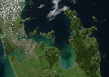
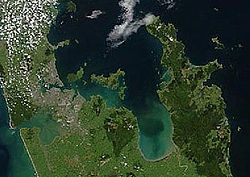
A true-colour image showing Auckland city (left), the Hauraki Gulf (centre) and the Coromandel Peninsula (right). The scene was acquired by NASA's Terra satellite, on October 23, 2002.

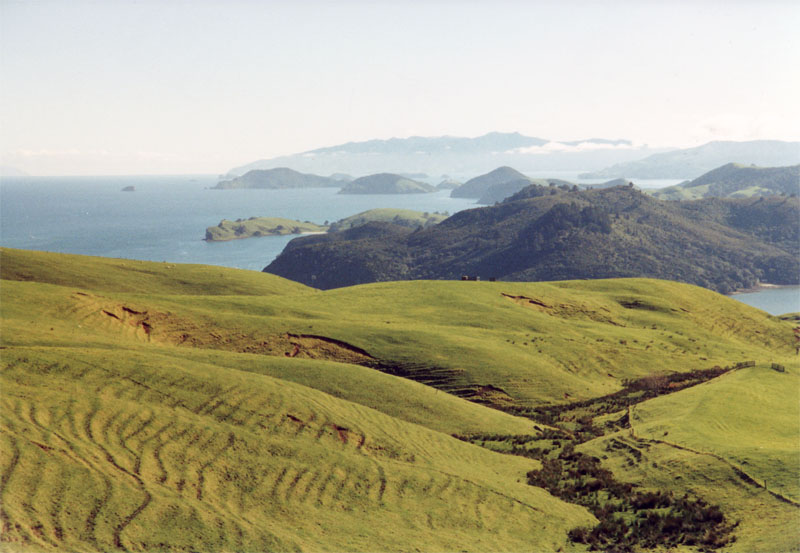
The Coromandel Range is a ridge of rugged hills running the length of the Coromandel Peninsula in the North Island of New Zealand. It is located 60 kilometres east of the city of Auckland, and runs north-south for approximately 85 kilometres. The highest point in the range is Mount Moehau (892 metres), at the northern end of the peninsula within the Moehau Range. There are numerous peaks over 600 metres in height.

The range is one of several that form a spine running through the northern North Island. To the south of the Coromandel Range, separated by the winding Karangahake Gorge, the spine continues with the Kaimai Range.

The large island of Great Barrier, at the entrance to the Hauraki Gulf due north of the Coromandel Peninsula, can be thought of as a northern continuation of this spine.

Coordinates: 37°00′S 175°40′E / 37°S 175.667°E / -37; 175.667


Wikimedia Foundation. 2010.

Игры ⚽ Поможем написать курсовую

Look at other dictionaries:

  • Coromandel Range — p1dep2 Coromandel Range Aufnahme eines NASA Erdbeobachtungssatelliten vom 23. Oktober 2002 mit der Stadt Auckland (links) dem Hauraki Gulf …   Deutsch Wikipedia

  • Coromandel-Halbinsel — Coromandel Peninsula Die Coromandel Peninsula (Halbinsel) liegt auf der Nordinsel von Neuseeland mit einer Länge von 85 Kilometer. Sie liegt westlich der Bay of Plenty und grenzt den westlich liegenden Hauraki Golf mit dem Firth of Thames… …   Deutsch Wikipedia

  • Coromandel-Peninsula — Die Coromandel Peninsula (Halbinsel) liegt auf der Nordinsel von Neuseeland mit einer Länge von 85 Kilometer. Sie liegt westlich der Bay of Plenty und grenzt den westlich liegenden Hauraki Golf mit dem Firth of Thames teilweise vom Pazifik ab.… …   Deutsch Wikipedia

  • Coromandel Peninsula — Gewässer 1 Hauraki Golf, Firth of Thames (Pazifischer Ozean) Gewässer 2 Bay of Plenty Geographische Lage …   Deutsch Wikipedia

  • Coromandel Peninsula — This article is about the Coromandel Peninsula in New Zealand. For the similarly named region in India, see Coromandel Coast. Location of Coromandel Peninsula …   Wikipedia

  • Coromandel Peninsula — ▪ peninsula, New Zealand       peninsula, east central North Island, New Zealand. Extending into the South Pacific Ocean for 70 miles (110 km) and averaging 20 miles in width, the promontory is bordered by the Firth of Thames and Hauraki Gulf to… …   Universalium

  • Coromandel Valley, South Australia — Coromandel Valley Adelaide, South Australia Population: 3,779 (2006 Census)[1] Postcode: 505 …   Wikipedia

  • Coromandel East, South Australia — Coromandel East Adelaide, South Australia Population: 296 (2006 Census)[1] Postcode: 5157 …   Wikipedia

  • Coromandel Coast — This article is about the Coromandel Coast of India. For the similarly named region in New Zealand, see Coromandel Peninsula. Districts along the Coromandel Coast …   Wikipedia

  • Thames-Coromandel-Distrikt — Thames Coromandel District Council Karte Basisdaten …   Deutsch Wikipedia

Share the article and excerpts

Direct link
Do a right-click on the link above
and select “Copy Link”