- Beerangali
Union Councils
name = Berin Gali
caption = Berin Gali is located inAbbottabad District .
province =NWFP
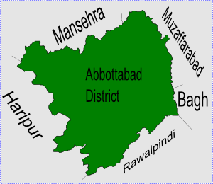
district = Abbottabad
tehsil = Abbottabad
nazim = Sardar Lal Khan Anwar [http://www.abbottabad.gov.pk/Union-council/UCDetailPage.asp?name=Beerangali Beerangali Union Council] ]
naib nazim = Sardar Muhammad Iqbal Khan
population = 12,329
coordinates = 34°11'40N 73°21'50EBerin Gali (also known as 'Beeran Gali' or 'Baran Gali') is a Union Council of
Abbottabad District , in theNorth-West Frontier Province ofPakistan . [ [http://www.abbottabad.sdnpk.org/adminunit.htm Administrative Units of District Abbottabad] ]History
This area was historically known as "Baad Burhan" and is mentioned by Al Biruni in his famous book Ta'rikh al-Hind, The Chronicles of India, from
1030 . Al Biruni describes Baad Burhan as a beautiful area.Topography
The area is situated between two mountains,
Thandiani andMiranjani . It is located at 34°11'40N 73°21'50E and has an average elevation of 2176 metres (7142 feet) above sea-level. [ [http://www.fallingrain.com/world/PK/3/Biran_Gali2.html Falling Rain Genomics - Location of Biran Gali] ]ubdivisions
The Union Council is subdivided into the following areas:Andarseri, Beerangali and Jhafar. [ [http://www.abbottabad.gov.pk/Union-council/viewmap.asp?name=Beerangali Map of subdivisions of Beerangali Union Council] ]
Notable areas
Notable areas of Berin Gali are Dara, Masta, Bunj and Jogi Mar.Fact|date=December 2007
Demographics
Its population numbers about 12,300. [ [http://www.abbottabad.gov.pk/Union-council/UCDetailPage.asp?Name=Beerangali Beerangali Union Council] ] Ethnically, the two main tribes are the
Karlal or 'Kiraal' and theQuraishi . In popular local lore, the inhabitants of this area are particularly courageous.References
Wikimedia Foundation. 2010.