- Mitterskirchen
-
Mitterskirchen 

 MitterskirchenLocation of Mitterskirchen within Rottal-Inn district
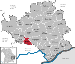
Coordinates 48°21′N 12°44′E / 48.35°N 12.73333°ECoordinates: 48°21′N 12°44′E / 48.35°N 12.73333°E Administration Country Germany State Bavaria Admin. region Lower Bavaria District Rottal-Inn Mayor Georg Hölzl (CSU) Basic statistics Area 24.77 km2 (9.56 sq mi) Elevation 433 m (1421 ft) Population 2,087 (31 December 2010)[1] - Density 84 /km2 (218 /sq mi) Other information Time zone CET/CEST (UTC+1/+2) Licence plate PAN Postal code 84335 Area code 08725 Website www.mitterskirchen.de Mitterskirchen is a municipality in the district of Rottal-Inn in Bavaria in Germany.
Contents
Geography
Mitterskirchen is situated in a small side-valley of the Rott, bordering on the district of Oberbayern (upper Bavaria). Mitterskirchen is at the federal highway B588, about seven kilometers south-west of Eggenfelden, 18 kilometers north of Altötting, 23 kilometers north-east of Mühldorf, as well as 22 kilometers south-west of the district capital Pfarrkirchen. The next train station on the railway line Passau - Mühldorf is in Eggenfelden.
History
Mitterskirchen used to belong to the "Rentamt" Landshut and the "Landgericht" (court) Eggenfelden of the Electorate Bavaria. The "Freiin" of Ingenheim, born a von Closen of Gern and Arnstorf, owned an open "Hofmark" here in 1800. During the administrative reforms in Bavaria, today's municipality was established by the 1818 "Gemeindeedikt".
Development
In the municipality, 1.453 inhabitants were counted in 1970, then 1.612 in 1987 and 1.959 in the year 2000. The recent head count in 2007 is 2.068
Politics
The mayor is Georg Hölzl (CSU - Chrstian Social Union & Heimatblock), an automobile expert. This is his second term.
Municipal tax revenue in 1999 was about 705.000 Euros, of which about 191.000 Euros were the net business tax revenue.
Economy and Infrastructure
Economy as well as Agri- and forestry
In 1998, according to official statistics, there were 6 people employed in agriculture and forestry, 175 in production and 9 in commerce and traffic at this location. In other economic areas, 43 people were employed. There was a total of 661 employees at this place of residence. There were two businesses in the processing sector, six in construction. Furthermore, there were 87 farms in 1999 with an agriculturally-used area of 1,574 acres (6.37 km2) total, of which 998 acres (4.04 km2) were fields and 576 acres (2.33 km2) verdure.
Infrastructure
An extension of the federal highway from Eggenfelden to Altötting was finished in 2008, passing the village at a further distance now, and cutting through between the village's north-eastern limits and its adjacent neighborhood Leitenbach. The extension was necessary due to the bad condition of the original pieces of street that went through the village and the commuting traffic and heavy trucks.
Education
In 1999:
- Kindergarten: 75 spots with 86 children
- Elementary school: 1 with 18 teachers and 314 students
The school was extended with an additional building in 2004/2005.
Arnstorf | Bad Birnbach | Bayerbach | Dietersburg | Eggenfelden | Egglham | Ering | Falkenberg | Gangkofen | Geratskirchen | Hebertsfelden | Johanniskirchen | Julbach | Kirchdorf am Inn | Malgersdorf | Massing | Mitterskirchen | Pfarrkirchen | Postmünster | Reut | Rimbach | Roßbach | Schönau | Simbach am Inn | Stubenberg | Tann | Triftern | Unterdietfurt | Wittibreut | Wurmannsquick | Zeilarn
References
- ^ "Fortschreibung des Bevölkerungsstandes" (in German). Bayerisches Landesamt für Statistik und Datenverarbeitung. 31 December 2010. https://www.statistikdaten.bayern.de/genesis/online?language=de&sequenz=tabelleErgebnis&selectionname=12411-009r&sachmerkmal=QUASTI&sachschluessel=SQUART04&startjahr=2010&endjahr=2010.
Categories:- Municipalities in Bavaria
- Rottal-Inn
- Lower Bavaria geography stubs


Wikimedia Foundation. 2010.