- Möhrendorf
-
Möhrendorf 

 MöhrendorfLocation of the town of Möhrendorf within Erlangen-Höchstadt district
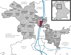
Coordinates 49°38′N 11°00′E / 49.63333°N 11°ECoordinates: 49°38′N 11°00′E / 49.63333°N 11°E Administration Country Germany State Bavaria Admin. region Middle Franconia District Erlangen-Höchstadt Town subdivisions 3 districts Mayor Konrad Rudert (FW) Basic statistics Area 13.16 km2 (5.08 sq mi) Elevation 272 m (892 ft) Population 4,447 (31 December 2010)[1] - Density 338 /km2 (875 /sq mi) Other information Time zone CET/CEST (UTC+1/+2) Licence plate ERH Postal code 91096 Area codes 09131, 09133 Website www.moehrendorf.de Möhrendorf is a town in the district of Erlangen-Höchstadt, in Bavaria, Germany.
Adelsdorf | Aurachtal | Baiersdorf | Bubenreuth | Buckenhof | Eckental | Gremsdorf | Großenseebach | Hemhofen | Heroldsberg | Herzogenaurach | Heßdorf | Höchstadt | Kalchreuth | Lonnerstadt | Marloffstein | Möhrendorf | Mühlhausen | Oberreichenbach | Röttenbach | Spardorf | Uttenreuth | Vestenbergsgreuth | Wachenroth | Weisendorf
References
- ^ "Fortschreibung des Bevölkerungsstandes" (in German). Bayerisches Landesamt für Statistik und Datenverarbeitung. 31 December 2010. https://www.statistikdaten.bayern.de/genesis/online?language=de&sequenz=tabelleErgebnis&selectionname=12411-009r&sachmerkmal=QUASTI&sachschluessel=SQUART04&startjahr=2010&endjahr=2010.
Categories:- Towns in Bavaria
- Erlangen-Höchstadt
- Middle Franconia geography stubs


Wikimedia Foundation. 2010.