- Old Crow Wing, Minnesota
-
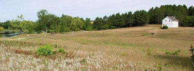 The 1849 Beaulieu House, sole remaining structure of the once bustling Crow Wing, overlooks the townsite and the Mississippi River in Crow Wing State Park.
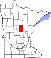
Old Crow Wing is a ghost town in Fort Ripley Township, Crow Wing County, Minnesota, United States, at the confluence of the Mississippi and Crow Wing rivers. For over a century, it was the northernmost European-American settlement on the Mississippi. In the 1850s and 1860s, it was the county seat and one of the major population centers of the state. At its peak there were an estimated 600–700 residents, about half of them Ojibwe. The town site, including one restored house, is preserved within Crow Wing State Park.
History
This area was inhabited by indigenous peoples for thousands of years before the first encounter with Europeans. At the confluence of the Crow Wing and Mississippi Rivers, the site of the village of Old Crow Wing became a logical meeting place for the Dakota and later Ojibwe of Minnesota.[1]
Old Crow Wing's strategic location also made it attractive to European traders, the first being recorded shortly after the close of the French and Indian War in 1763. The first trader of note to spend time at Old Crow Wing was James McGill in the winter of 1771–2, followed by many others. It also seems likely that two British army officers of the 54th Regiment of Foot visited the site in the early autumn of 1789, although the nature of this visit is disputed.[2]
The first European-American settler in Crow Wing was Allan Morrison, who opened a trading post in 1823. Around this time a lucrative, if technically illegal (because of post-War of 1812 restrictions on trading with Canadians), trade formed between Saint Paul, Minnesota, and the Red River Colony in Canada. Many of the fur traders were Métis, the biracial descendants of Ojibwa women and French, Scots and English men.
Since the Red River Trails crossed territory of the Dakota, the Ojibwa's traditional enemy, conflicts dogged the trade. A Métis attack on the Dakota in 1844 closed the primary route entirely. A Red River ox cart train on its return trip north traveled instead to the growing town of Crow Wing, forded the Mississippi, and blazed a new route that passed through much friendlier Ojibwa lands.
This route became known as the Woods Trail. Although it was considerably harder going than the other Red River Trails, it was decidedly safer. More traffic followed, particularly whenever relations with the Dakota were at their worst.
The village of Crow Wing became the principal supply station on the Woods Trail. Allan Morrison began operating a ferry across the Mississippi at the north end of town. In the 1840s other traders set up shop as well. Allan and his brother William Morrison, William Alexander Aitken, and Henry Mower Rice were traders who all went on to such prominence that Minnesota's Morrison County, Aitkin County, and Rice County were named after them. Mower served as a state senator for five years and ran for governor in 1865.
Another successful trader was Clement Beaulieu, a Métis who ran the American Fur Company's trading post.
Another mixed-race resident, the American William Whipple Warren, interviewed Ojibwa elders and completed his classic History of the Ojibway People in 1853. (It was published by the Minnesota Historical Society in 1885.) Warren married William Aitkin's daughter and served in the territorial legislature. Several important Ojibwa leaders lived in Crow Wing, including Curly Head, Hole in the Day, Hole-in-the-Day II, and Strong Ground. Henry Rice negotiated with them for logging rights, and logging became a significant industry in Crow Wing.
The U.S. Military established Fort Ripley nearby in 1848. In 1849 Clement Beaulieu had a house built for himself and his wife Elizabeth with Greek Revival architecture. Father Francis Xavier Pierz established a Catholic mission in Crow Wing in 1852.[3] An Episcopal mission was built in 1856, and a Lutheran church soon after.
Two events brought Crow Wing's heyday to a swift end. In 1868 the Ojibwa, including Clement and Elizabeth Beaulieu, were resettled in the White Earth Indian Reservation. In 1871 railroad magnate James J. Hill decided to route his Northern Pacific Railway over the Mississippi River in Brainerd, ten miles to the north. A year later Brainerd became the county seat.
By 1880 most of Crow Wing's residents had moved on. Two of Beaulieu's nephews moved their uncle's former house to Morrison County, where it was inhabited continuously into the 1980s. After Larry and Joyce Moran of Little Falls, Minnesota donated the house to the Minnesota Department of Natural Resources, the house was moved back to its original location in 1988.
References
- ^ Warren, William W. (1885). History of the Ojibwe People. St. Paul, Minn.: Minnesota Historical Society Press. p. 263.
- ^ Woodward, Morgan P. (2011). Redcoats on the Upper Mississippi: British Espionage and Diplomacy at Old Crow Wing. St. Cloud, Minn.: Woody Productions.
- ^ Voigt, Robert J. (1989). Crow Wing and Father Pierz. St. Cloud, Minn.: Diocese of St. Cloud.
External links
Municipalities and communities of Crow Wing County, Minnesota Cities Baxter | Brainerd | Breezy Point | Crosby | Crosslake | Cuyuna | Deerwood | Emily | Fifty Lakes | Fort Ripley | Garrison | Ironton | Jenkins | Manhattan Beach | Nisswa | Pequot Lakes | Riverton | Trommald
Townships Bay Lake | Center | Crow Wing | Daggett Brook | Deerwood | Fairfield | Fort Ripley | Gail Lake | Garrison | Ideal | Irondale | Jenkins | Lake Edwards | Little Pine | Long Lake | Maple Grove | Mission | Nokay Lake | Oak Lawn | Pelican | Perry Lake | Platte Lake | Rabbit Lake | Roosevelt | Ross Lake | Sibley | St. Mathias | Timothy | Wolford
Unorganized
territoriesUnincorporated
communityLake Hubert
Indian
reservationGhost town Old Crow Wing
Categories:- Geography of Crow Wing County, Minnesota
- Ghost towns in Minnesota
- Pre-state history of Minnesota


Wikimedia Foundation. 2010.