- Mainit, Surigao del Norte
-
Municipality of Mainit
Lungsod nan Mainit
Bayan ng Mainit
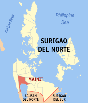
SealMap of Surigao del Norte showing the location of Municipality of Mainit
Coordinates: 8°57′N 125°32′E / 8.95°N 125.533°E Country Philippines Region Region XIII Province Surigao del Norte (Seat of Government) Districts Second District of Surigao del Norte Barangays 21 Official Languages Cebuano, Surigaonon Widely Spoken, Filipino, English Class 4th Class Municipality Government - Mayor Ramon B. Mondano (2007-Present) - Vice Mayor Rogelio M. Gatpolintan (2010-Present) - Congress Guillermo A. Romarate, Jr. (2007-Present) Time zone PST (UTC+8) ZIP code 8407 Patron Saint San Nicolas Membership Lake Mainit Development Alliance Website http://mainitsurigao.wordpress.com Mainit is a 4th class municipality in the province of Surigao del Norte, Philippines. It is situated by Lake Mainit in the northeastern part of Mindanao. The word "mainit" literally means "hot". According to the 2000 census, it has a population of 23,417 people in 4,621 households.
Contents
Barangays
Mainit is politically subdivided into 21 barangays. In 1956, the sitios of Magpayang and Siana were elevated as barrios.[1]
- Binga
- Bobona-on
- Cantugas
- Dayano
- Mabini
- Magpayang
- Magsaysay (Pob.)
- Mansayao
- Marayag
- Matin-ao
- Paco
- Quezon (Pob.)
- Roxas
- San Francisco
- San Isidro
- San Jose
- Siana
- Silop
- Tagbuyawan
- Tapi-an
- Tolingon
History
The first inhabitants of Mainit settled near Lake Mainit in what is now barangay San Isidro. It was believed that the constant harassment of pirates forced the original settlers to move to the present town site.
Mainit was made into a barrio in 1904 under the Municipality of Placer. In 1906, it became a Municipality of Agusan Province but after six months, Mainit was returned to the Province of Surigao del Norte and its status was reverted to being a barangay of Placer. Mainit was finally made into a municipality in Jan. 1, 1931 by virtue of Executive Order 290 dated December 27, 1930 signed by Governor-General Dwight F. Davis.
Two of Mainit’s barangay was made into a Municipality: Tubod in 1958 and Alegria in 1968.
Mainit got its name from the hot sulfuric spring which flows to the river the “Mapaso Hot Spring”. Mapaso literally is “hot”. [2]
References
- ^ "An Act Converting into Barrios Certain Sitios in the Province of Surigao, and Dividing the Barrio of Macalaya into Two Barrios, Municipality of Placer, in the Same Province". LawPH.com. http://lawph.com/statutes/ra1543.html. Retrieved 2011-04-12.
- ^ Municipality of Mainit (2009-12-21). "History, Vision and Mission". http://mainitsurigao.wordpress.com/2009/12/21/history-vision-mission. Retrieved 2010-09-15.
External links
- Municipal Website Blog of Mainit
- Discover Mainit
- About Mainit
- Official Website of the Municipality of Mainit
- Philippine Standard Geographic Code
- 2000 Philippine Census Information
- A Civil Society Organization of Mainit, Surigao del Norte
- Write-ups and literature about Mainit and Mainitnons
- Mainitnons in Northern America,USA and CANADA
Municipalities Alegria • Bacuag • Burgos • Claver • Dapa • Del Carmen • General Luna • Gigaquit • Mainit • Malimono • Pilar • Placer • San Benito • San Francisco • San Isidro • Santa Monica • Sison • Socorro • Tagana-an • TubodComponent city SurigaoCategories:- Municipalities of Surigao del Norte
Wikimedia Foundation. 2010.