- River Conwy
-
Conwy (Afon Conwy) River  Boats in the river estuary at Conwy
Country Wales District County Borough of Conwy Tributaries - left Machno, Lledr, Llugwy, Crafnant City Conwy Source - location Migneint moor where a number of small streams flow into Llyn Conwy, Gwynedd Mouth Conwy estuary - location Irish Sea, Wales Length 43 km (27 mi) Discharge for Cwm Llanerch - average 18.59 m3/s (656 cu ft/s) The River Conwy (Welsh: Afon Conwy) is a river in north Wales. From its source to its discharge in Conwy Bay it is a little over 27 miles (43 km) long. "Conwy" is sometimes Anglicized as "Conway."
It rises on the Migneint moor where a number of small streams flow into Llyn Conwy, then flows in a generally northern direction, being joined by the tributaries of the rivers Machno and Lledr before reaching Betws-y-Coed, where it is also joined by the River Llugwy. From Betws-y-coed the river continues to flow north through Llanrwst, Trefriw (where it is joined by the Afon Crafnant) and Dolgarrog (where it is joined by Afon Porth-llwyd and Afon Ddu) before reaching Conwy Bay at Conwy. During spring tides the river is tidal as far as Llanrwst.
Contents
Tributaries of the River Conwy
Named tributaries of the Conwy (and their tributaries) listed from source to sea -
Afon Machno
Afon Lledr
Afon Llugwy
Afon Gallt y Gwg
Nant y Goron
Afon Crafnant & Fairy Falls-
- Afon Geirionydd
Afon Ddu (1)
Afon Porth-llwyd
Afon Dulyn-
- Afon Ddu (2)
- Afon Garreg-wen
- Ffrwd Cerriguniawn
- Afon Melynllyn
Afon Hiraethlyn
Afon RoeAfon Gyffin
Geology and geomorphology
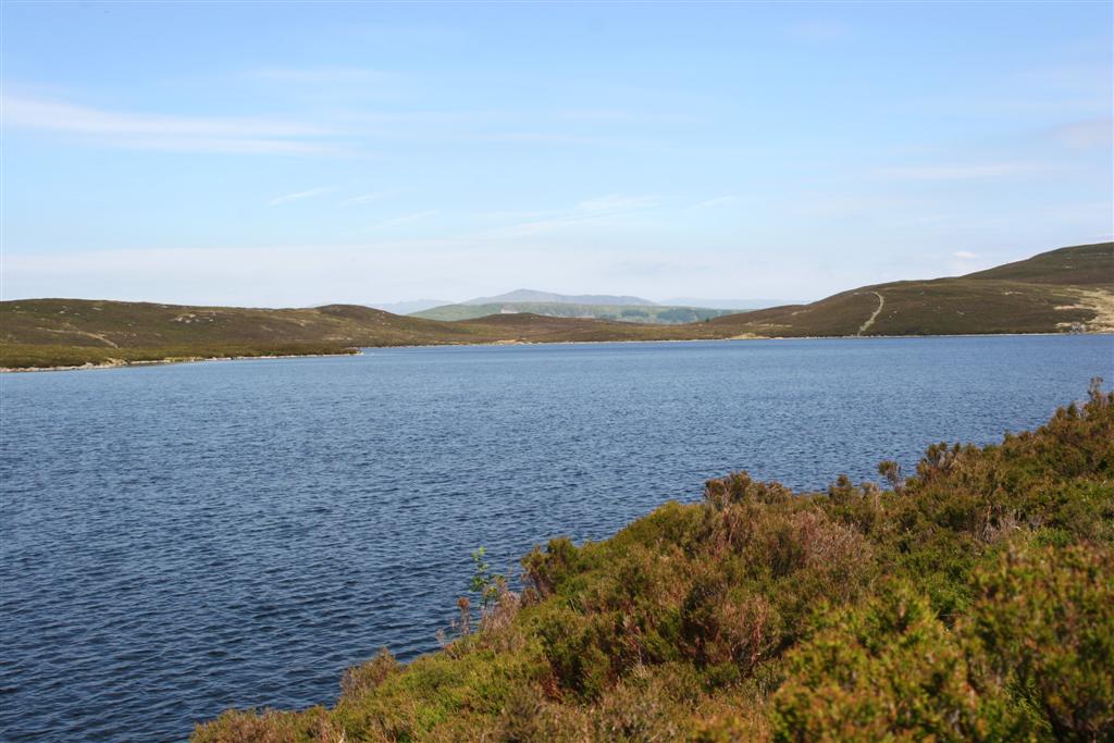
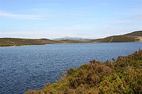 Llyn Conwy, the source of the River Conwy
The Conwy is bounded to the east by the rolling ancient mudstone hills of the Silurian period, the Migneint Moors. These acid rocks are generally covered in thin, often acid soils and for large parts of the upland areas the cover is of moor-grass — Mollinia spp and Erica communities. As a result the water entering the river tends to be acidic and often coloured brown with humic acids
To the west, the catchment is underlain by older Cambrian rocks which are harder and the landscape is, as a consequence, more dramatic with high craggy hills and mountains through which the river falls in cascades and waterfalls. Excellent examples of torrential river geomorphology can be seen at Conwy Falls and in the Lledr Gorge. The land to the East is highly forested with planted non-native conifers.
The western side of the valley is rich in lakes and reservoirs some of which provide drinking water supplies. The rocks are also rich in minerals and there are many abandoned mine sites where copper, lead and silver have been mined since Roman times.
The central river valley down-stream of Betws-y-Coed is relatively wide and fertile, and supports dairying and sheep rearing. In winter time these pastures are used to nurture the sheep brought down out of the mountains to avoid the worst of the winter weather.
Culture and history
The scattered communities along the Conwy valley have ancient traditions with archeological evidence of habitation back to the Stone Age. The Romans occupied this area up to 400 AD and there has been continuous habitation since that time. The valley is home to two of the oldest churches in Wales, those at Llanrhychwyn and Llangelynin, which respectively date back to the 11th and 12th centuries.
Much of the Conwy valley was laid waste in the Wars of the Roses by the Earl of Pembroke, under the orders of Edward IV, the Yorkist king, following a Lancastrian attack on the town of Denbigh in 1466.
At the mouth of the Conwy as it discharges into Conwy Bay is the town of Conwy with its World Heritage Site castle — Conwy Castle and two famous bridges. One of the earliest road suspension bridges by Thomas Telford now carries a footpath whilst Robert Stephenson's tubular iron bridge still carries the main Holyhead to London railway line. A third bridge now takes road traffic, and more recently still the A55 now runs in a tunnel under the estuary.
Water quality
The River Conwy is routinely monitored for quality by the Environment Agency. The river quality tends to be acidic in the headwaters with very low concentrations of the common anions and cations. Whilst conductivity rises as the river flows towards the sea, the overall organic quality remains very good despite some slight increases in ammonia due to diffuse agricultural inputs.
The Environment Agency also constantly monitors water levels in the valley, with a view to giving flood warnings. There are measuring stations at Betws-y-coed (Cwmlanerch) [1], Llanrwst [2] and Trefriw.[3]
The Conwy is noted for its salmon and sea trout although increasing acidification in the second half of the 20th century, especially in the poorly buffered upland waters has significantly impacted upon their spawning success. The construction of an artificial fish pass in the 1990s to allow migratory salmonids access to the river above Conwy falls was intended to help mitigate the effects of acidification.[4]
The Conwy Crossing, an immersed tube tunnel was built under the estuary during the late 1980s and early 1990s.[5] It was opened by the Queen in October 1991. This resulted in the loss of some saltmarsh but also led to the creation of Conwy RSPB Reserve.
Since 2002 the valley has been overlooked by the turbines of the Moel Maelogan wind farm.
Situation
The panorama shows the mouth of the Conwy Estuary from Deganwy Castle, the original defensive position of the area. However, problems with resupply in the event of siege and its destruction by Llywelyn ap Gruffudd, Prince of Wales in 1263 to prevent it falling in to King Edward's hands, led to a new castle being built across the water in Conwy town.
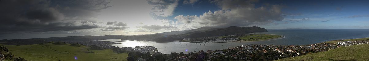 Panorama of six pictures stitched together showing the mouth of the Conwy Estuary (right) and the location of Conwy Castle (left of centre)
References
See also
- Conwy Valley Line (railway line)
- Rivers of Great Britain
- List of rivers of Europe
External links
Coordinates: 53°18′N 3°50′W / 53.3°N 3.833°WTowns Other Settlements Betws-y-coed • Caerhun • Dolgarrog • Eglwysbach • Glan Conwy • Henryd • Llanbedr-y-cennin • Llanddoged • Llangelynnin • Llanrhychwyn • Maenan • Rowen • Tal-y-bont • Tal-y-Cafn • Trefriw • Tyn-y-groes •
Rivers & Streams Afon Conwy • Afon Crafnant • Afon Geirionydd • Afon Hiraethlyn • Afon Machno • Afon Lledr • Afon Llugwy • Afon Gallt y Gwg • Nant y Goron • Afon Ddu (1) • Afon Porth-llwyd • Afon Dulyn • Afon Ddu (2) • Afon Garreg-wen • Ffrwd Cerriguniawn • Afon Melynllyn • Afon Roe • Afon Tafolog • Afon Gyffin •
Lakes Llyn Crafnant • Llyn Elsi • Llyn Geirionydd • Llyn y Parc •
Waterfalls Grey Mare's Tail • Fairy Falls •
Hills & Mountains Castles & Forts Canovium • Conwy Castle • Gwydir Castle • Pen y Gaer •
Other Features Bodnant Garden • Conwy RSPB reserve • Gwydir Forest • Moel Maelogan • Snowdonia National Park •
Transport A470 • B5106 • Conwy Valley Line •
Railway Stations Conwy County Borough Principal settlements Abergele • Colwyn Bay • Conwy • Llandudno • Llandudno Junction • Llanfairfechan • Llanrwst • Old Colwyn • Penmaenmawr • Penrhyn Bay
Towns and villages Bettws-y-Coed • Caerhun • Capel Curig • Capel Garmon • Cerrig-y-drudion • Deganwy • Dinmael • Dolgarrog • Dolwyddelan • Eglwysbach • Glan Conwy • Henryd • Kinmel Bay • Llanbedr-y-Cennin • Llanddoged • Llanddulas • Llanfair Talhaiarn • Llangernyw • Llanrhychwyn • Llysfaen • Maenan • Mochdre • Pandy Tudur • Penmachno • Rhos-on-Sea • Rowen • Tal-y-bont • Tal-y-Cafn • Trefriw • Towyn • Ysbyty IfanRivers River Conwy • River Crafnant • River Geirionydd • River Lledr • River Llugwy • River Machno • Afon Ddu • Afon Ddu (Drum) • Afon Dulyn • Afon Eigiau • Afon Lloer • Afon Melynllyn • Afon Porth-llwyd • Afon Roe • Afon TafologCastles and forts Canovium • Conwy Castle • Deganwy Castle • Dolwyddelan Castle • Gwrych Castle • Gwydir Castle • Pen y GaerCategories:- Rivers of Wales
- Geography of Conwy
-


Wikimedia Foundation. 2010.