Vartiokylä

Vartiokylä

Subdivisions of Helsinki
subdivision_name = Vartiokylä
subdivision_name_swe = Botby


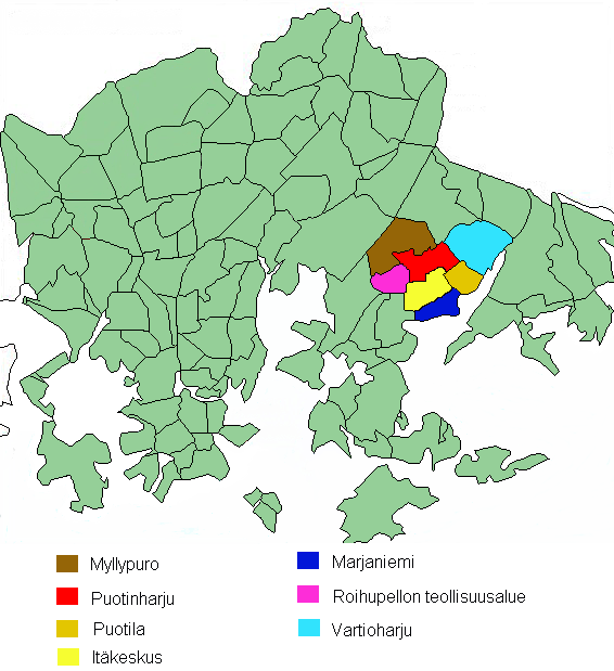
subdivision_number = 45
district = Eastern
area = 10.03
population = 30,403 (2005)
density = 3,031 (2005)
postcode = 00900, 00910, 00920, 00930, 00950
regions = Vartioharju, Puotila, Puotinharju, Myllypuro, Marjaniemi, Roihupellon teollisuusalue, Itäkeskus
neighbours = Viikki, Herttoniemi, Tammisalo, Mellunkylä, Vartiosaari, Vuosaari|

Vartiokylä ( _sv. Botby) is a neighbourhood in eastern Helsinki, the capital of Finland. Its name is derived from the ruins of an 11th century fortress on the Linnanvuori hill in Vartioharju, one of Vartiokylä's subdivisions. The working population of Helsinki started building their houses in the area after the completion of Uusi Porvoontie, a road to the downtown, in the 1930s. Nowadays the area has a few high density apartment areas as well as houses. Vartiokylä became a part of Helsinki in 1946. Most of the services in the district are located in the subdivision of Itäkeskus in the area around one of the largest shopping centers in the Nordic Countries.

The public transport in the area relies heavily on the Helsinki Metro. The stations of Itäkeskus, Myllypuro, and Puotila. Several bus lines serve the areas not within the walking distance of the stations. Two major highways Itäväylä and Kehä I intersect in Vartiokylä.


Wikimedia Foundation. 2010.

Игры ⚽ Поможем написать реферат

Look at other dictionaries:

  • Vartiokylä — 60°13′N 025°06′E / 60.217, 25.1 …   Wikipédia en Français

  • Vartsika — Vartiokylä Jorot on siel Vartsikan työviksellä …   Suomen slangisanakirjaa

  • Myllypuro — Myllypuro(fi) Kvarnbäcken (sv) …   Wikipédia en Français

  • Subdivisions of Helsinki — The city of Helsinki, the capital of Finland, can be divided into various different sorts of subdivisions. The subdivisions include neighbourhoods, districts, major districts and postal code areas. The plethora of different official ways to… …   Wikipedia

  • Marjaniemi — Marudd Subdivisions of Helsinki …   Wikipedia

  • Itäkeskus — 60°12′40″N 25°04′55″E / 60.21111, 25.08194 …   Wikipédia en Français

  • Subdivisions d'Helsinki — La ville d Helsinki, capitale de la Finlande, est découpée en subdivisions de tailles et de natures variées. Le découpage fait intervenir des quartiers, des districts, des superdistricts, des sections et des secteurs. Sa complexité le rend… …   Wikipédia en Français

  • Itäinen suurpiiri — Itäinen suurpiiri(fi) Östra stordistriktet (sv) …   Wikipédia en Français

  • Marjaniemi — 60°12′15″N 25°5′15″E / 60.20417, 25.0875 Ma …   Wikipédia en Français

  • Puotila — Puotila(fi) Botby gård (sv) …   Wikipédia en Français

Share the article and excerpts

Direct link
Do a right-click on the link above
and select “Copy Link”