- Middlesex Turnpike (Massachusetts)
-
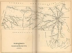

Map of the 19th century turnpikes
in MassachusettsThe Middlesex Turnpike was an early turnpike between Cambridge and Tyngsborough, Massachusetts and the New Hampshire border, where it connected with the Amherst Turnpike and thence Nashua and Claremont, New Hampshire.
The turnpike was chartered on June 15, 1805, by the Massachusetts legislature. After an extremely contentious argument about its route, it opened about five years later. The road started near present-day Technology Square in East Cambridge, where it intersected with the Cambridge and Concord Turnpike (now Broadway), headed roughly northwest along what are now Hampshire and Beacon Streets, passed by the 'Foot of the Rocks' in West Cambridge (now along Massachusetts Avenue in Arlington), and onwards to Lexington by today's Westminster and Lowell Streets. From there, it continued through Burlington, Bedford, and Billerica, the section of which is still called the Middlesex Turnpike. Finally, it continued northwest to Chelmsford, and then along the bank of the Merrimack River to Tyngsborough. A small, 1.5-mile (2.4 km) stretch of the turnpike remains in Chelmsford, now known as "Turnpike Road." An extremely small section near North Chelmsford remains in a residential section of town, called "Old Middlesex Turnpike." From there, maps show a route along what appears to be North Road and Princeton Street into what is now North Chelmsford's Vinal Square, then Tyngsboro Road into Tyngsboro, and north to Nashua. It was about 26 miles (42 km) in length, with 4 toll gates along the way.
As was the practice of that time, the road was as straight as possible, and thus missed the advantages of passing through economic centers along the way. As its route closely paralleled that of the Middlesex Canal, and later the railroad, it suffered stiff competition for both freight and passenger traffic. The road was thus never particularly profitable. Its charter was repealed in 1841, and it became a free road in 1846. Some sections became disused at some point - there is a section in Billerica at the Concord River that is discontinuous, and a large section missing between Billerica (River Street) and Chelmsford (Mill Road).
U.S. Route 3, the expressway largely built in the 1950s from Burlington to Tyngsboro, follows the path of the Middlesex Turnpike very closely.
Improvement Project
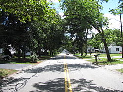
Old Middlesex Turnpike in Billerica The MassDOT is planning to upgrade the Middlesex Turnpike in cooperation with the Towns of Burlington, Bedford and Billerica. Phase 2 which begins in Burlington at Route 62 and Middlesex Turnpike and stretches into Bedford just north of Crosby Drive. Phase 1 was Completed in 2007. Total cost of Phase 2 is expected to be $13 Million+. Construction on Phase 2 is expected to begin in July 2010. The contractor for Phase 2 is Newport Construction Corporation of Nashua Hew Hampshire.
Billerica is planning that phase 3 become a multi-modal corridor -- a green road plus 3 modes, including transit, bike lanes and sidewalks for pedestrians.
See also
References
- Frederic James Wood, The Turnpikes of New England and Evolution of the Same Through England, Virginia, and Maryland, Boston: Marshall Jones Company, 1919, pages 148-157.
- Rev. Wilson Waters, History of Chelmsford, Massachusetts, Lowell, Massachusetts : Courier-Citizen Company, 1917, page 439.
- Henry Allen Hazen, History of Billerica, Massachusetts: with a Genealogical register, Boston : A. Williams and Co., 1883, page 274.
- Benjamin and William R. Cutter, History of the Town of Arlington, Massachusetts, Boston : David Clapp and Son, 1880, page 128.
- Charles Hudson, History of the town of Lexington, Middlesex County, Massachusetts: From Its First Settlement to 1868, Lexington Historical Society, Lexington, Mass, Houghton Mifflin Co., 1913, page 473.
Categories:- Cambridge, Massachusetts
- History of Massachusetts
- Roads in Massachusetts
- Pre-freeway turnpikes in the United States


Wikimedia Foundation. 2010.