- Nora Township, Jo Daviess County, Illinois
-
Nora Township — Township — Location in Jo Daviess County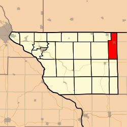 Jo Daviess County's location in Illinois
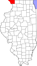
Coordinates: 42°26′08″N 89°57′22″W / 42.43556°N 89.95611°WCoordinates: 42°26′08″N 89°57′22″W / 42.43556°N 89.95611°W Country United States State Illinois County Jo Daviess Established November 2, 1852 Government - Supervisor Donna P. Paige Area - Total 25.31 sq mi (65.55 km2) - Land 25.31 sq mi (65.55 km2) - Water 0 sq mi (0 km2) 0% Elevation 981 ft (299 m) Population (2000) - Total 404 - Density 16/sq mi (6.2/km2) Time zone CST (UTC-6) - Summer (DST) CDT (UTC-5) ZIP codes 61048, 61059, 61085, 61087, 61089 GNIS feature ID 0429452 Nora Township is one of twenty-three townships in Jo Daviess County, Illinois, USA. As of the 2000 census, its population was 404[1].
Contents
Geography
According to the United States Census Bureau, Nora Township covers an area of 25.31 square miles (65.6 km2).
Cities, towns, villages
Adjacent townships
- Winslow Township, Stephenson County (northeast)
- West Point Township, Stephenson County (east)
- Kent Township, Stephenson County (southeast)
- Wards Grove Township (south)
- Stockton Township (southwest)
- Rush Township (west)
- Warren Township (northwest)
Cemeteries
The township contains these three cemeteries: East Chelsea, Nora and West Chelsea.
Major highways
School districts
- Lena Winslow Community Unit School District 202
- Stockton Community Unit School District 206
- Warren Community Unit School District 205
Political districts
- Illinois' 16th congressional district
- State House District 89
- State Senate District 45
References
- "Nora Township, Jo Daviess County, Illinois". Geographic Names Information System, U.S. Geological Survey. http://geonames.usgs.gov/pls/gnispublic/f?p=gnispq:3:::NO::P3_FID:0429452. Retrieved 2010-01-17.
- United States Census Bureau 2007 TIGER/Line Shapefiles
- United States National Atlas
External links
- Jo Daviess County official site
- City-Data.com
- Illinois State Archives
- Township Officials of Illinois
Municipalities and communities of Jo Daviess County, Illinois County seat: Galena Cities 
Villages Apple River | Elizabeth | Hanover | Menominee | Nora | Scales Mound | Stockton | Warren
Townships Apple River | Berreman | Council Hill | Derinda | Dunleith | East Galena | Elizabeth | Guilford | Hanover | Menominee | Nora | Pleasant Valley | Rawlins | Rice | Rush | Scales Mound | Stockton | Thompson | Vinegar Hill | Wards Grove | Warren | West Galena | Woodbine
Unincorporated
communitiesGhost town Categories:- Townships in Jo Daviess County, Illinois


Wikimedia Foundation. 2010.