- List of parishes in Louisiana
-
The U.S. state of Louisiana is divided into 64 parishes in the same way that 48 of the other states of the United States are divided into counties (Alaska is divided into boroughs and census areas).
Forty-one parishes are governed by a council called the Police Jury. The other twenty-three have various other forms of government, including: president-council, council-manager, parish commission, and consolidated parish/city.
Louisiana was formed from French and Spanish colonies, which were both officially Roman Catholic. Local government was based upon parishes, as the local ecclesiastical division (French: paroisse or Spanish: parroquia). Following the Louisiana Purchase in 1803, the Territorial Legislative Council divided the Territory of Orleans (the predecessor of Louisiana state) into twelve counties. The borders of these counties were poorly defined, but they roughly coincided with the colonial parishes, and hence used the same names.[1]
On March 31, 1807, the territorial legislature divided the state into 19 parishes without abolishing the old counties (which continued to exist until 1845).[2]
In 1811, a constitutional convention was held to prepare for Louisiana's admission into the Union.[3] This organized the state into seven judicial districts, each consisting of groups of parishes. In 1816, the first official map of the state used the term, as did the 1845 constitution. Since then, the official term for Louisiana's primary civil divisions has been parishes.
Listing
Parish FIPS code
[4]Parish seat
[5]Established
[5]Origin Etymology
[6]Population
[5]Area
[5]Map
Acadia Parish 001 Crowley 1886 from part of St. Landry Parish. Named for the Acadians who settled the area. 61,773 658 sq mi
(1,704 km2)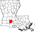
Allen Parish 003 Oberlin 1912 from part of Calcasieu Parish. Henry Watkins Allen, the Confederate governor of Louisiana 25,764 766 sq mi
(1,984 km2)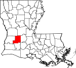
Ascension Parish 005 Donaldsonville 1807 One of the original 19 parishes. Named for the Ascension of Our Lord Catholic Church in Donaldsonville, Louisiana 107,215 303 sq mi
(785 km2)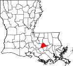
Assumption Parish 007 Napoleonville 1807 One of the original 19 parishes. Named for the Assumption Roman Catholic Church, the oldest in the state 23,421 364 sq mi
(943 km2)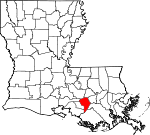
Avoyelles Parish 009 Marksville 1807 One of the original 19 parishes. The Avoyel Native American people 42,073 866 sq mi
(2,243 km2)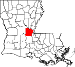
Beauregard Parish 011 DeRidder 1912 from part of Calcasieu Parish. Confederate general P. G. T. Beauregard 35,654 1,166 sq mi
(3,020 km2)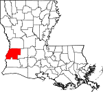
Bienville Parish 013 Arcadia 1848 from part of Claiborne Parish. Named after the founder of the city of New Orleans, Jean-Baptiste Le Moyne de Bienville 14,353 822 sq mi
(2,129 km2)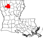
Bossier Parish 015 Benton 1843 from part Claiborne Parish. U.S. Representative Pierre Bossier 116,979 867 sq mi
(2,246 km2)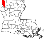
Caddo Parish 017 Shreveport 1838 from part of Natchitoches Parish. Named for the Caddo Native American people 254,969 937 sq mi
(2,427 km2)
Calcasieu Parish 019 Lake Charles 1840 from part of St. Landry Parish. Calcasieu, meaning crying eagle, is said to be the name of an Atakapa Native American leader 192,768 1,094 sq mi
(2,833 km2)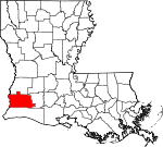
Caldwell Parish 021 Columbia 1838 from part of Catahoula Parish and Ouachita Parish. Named for the Caldwell family, which owned a large plantation and remains politically active in the state. 10,132 541 sq mi
(1,401 km2)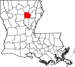
Cameron Parish 023 Cameron 1870 from parts of Calcasieu Parish and Vermilion Parish. U.S. Secretary of War Simon Cameron 6,839 1,932 sq mi
(5,004 km2)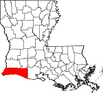
Catahoula Parish 025 Harrisonburg 1808 from parts of Ouachita Parish and Rapides Parish. Catahoula Lake, formerly within the parish's boundaries and named from a Taensa word meaning big, clear lake 10,407 739 sq mi
(1,914 km2)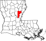
Claiborne Parish 027 Homer 1828 from part of Natchitoches Parish. Governor of Louisiana William C. C. Claiborne 17,195 768 sq mi
(1,989 km2)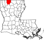
Concordia Parish 029 Vidalia 1807 One of the original 19 parishes. Name is of uncertain origin; may be from an early land grant called New Concordia, from the "concord" reached by local authorities over a mutual surrender of slaves, or for a mansion called Concord which was owned by Spanish Governor Manuel Gayoso de Lemos 20,822 749 sq mi
(1,940 km2)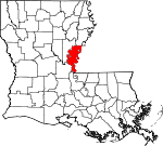
DeSoto Parish 031 Mansfield 1843 from parts of Caddo Parish and Natchitoches Parish. Spanish explorer Hernando de Soto 26,656 895 sq mi
(2,318 km2)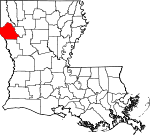
East Baton Rouge Parish 033 Baton Rouge 1810 from West Florida territory. French phrase bâton rouge meaning red stick. A red stick was used by local Native Americans to mark the boundaries between tribal territories 440,171 471 sq mi
(1,220 km2)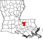
East Carroll Parish 035 Lake Providence 1877 when Carroll Parish was divided. Charles Carroll of Carrollton, the last surviving signer of the U.S. Declaration of Independence 7,759 442 sq mi
(1,145 km2)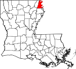
East Feliciana Parish 037 Clinton 1824 when Feliciana Parish was divided. Felicite de Gálvez, the wife of Bernardo de Gálvez, a Spanish governor of the Louisiana Territory 20,267 456 sq mi
(1,181 km2)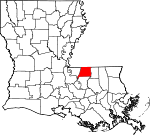
Evangeline Parish 039 Ville Platte 1910 from part of St. Landry Parish. Acadian heroine of the poem "Evangeline" by Henry Wadsworth Longfellow 33,984 680 sq mi
(1,761 km2)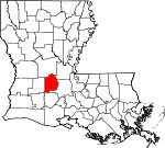
Franklin Parish 041 Winnsboro 1843 from parts of Carroll Parish, Catahoula Parish, Madison Parish and Ouachita Parish Founding Father Benjamin Franklin 20,767 636 sq mi
(1,647 km2)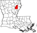
Grant Parish 043 Colfax 1869 from parts of Rapides Parish and Winn Parish. U.S. President Ulysses S. Grant 22,309 664 sq mi
(1,720 km2)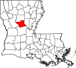
Iberia Parish 045 New Iberia 1868 from parts of St. Martin Parish and St. Mary Parish. Named by Spanish settlers in honor of the Iberian Peninsula 73,240 1,031 sq mi
(2,670 km2)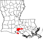
Iberville Parish 047 Plaquemine 1807 One of the original 19 parishes. Explorer Pierre Le Moyne d'Iberville, the brother of Jean-Baptiste Le Moyne de Bienville 33,387 653 sq mi
(1,691 km2)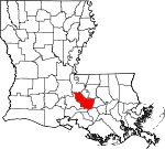
Jackson Parish 049 Jonesboro 1845 from parts of Claiborne Parish, Ouachita Parish and Union Parish U.S. President Andrew Jackson 16,274 580 sq mi
(1,502 km2)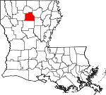
Jefferson Parish 051 Gretna 1825 from part of Orleans Parish Founding Father Thomas Jefferson 432,552 642 sq mi
(1,663 km2)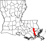
Jefferson Davis Parish 053 Jennings 1912 from part of Calcasieu Parish. Jefferson Davis, president of the Confederate States of America 31,594 659 sq mi
(1,707 km2)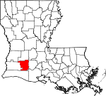
Lafayette Parish 055 Lafayette 1823 from part of St. Martin Parish. French-born American Revolutionary War hero the Marquis de la Fayette 221,578 270 sq mi
(699 km2)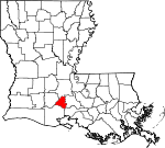
Lafourche Parish 057 Thibodaux 1807 One of the original 19 parishes. Was named Interior Parish until 1812 and Lafourche Interior Parish until 1853. French phrase la fourche or in English, the fork; Bayou Lafourche, or Fork Bayou, is a fork of the Mississippi River 96,318 1,472 sq mi
(3,812 km2)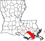
La Salle Parish 059 Jena 1908 from part of Catahoula Parish. Explorer René-Robert Cavelier, Sieur de La Salle 14,890 663 sq mi
(1,717 km2)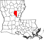
Lincoln Parish 061 Ruston 1873 from parts of Bienville Parish, Claiborne Parish, Jackson Parish and Union Parish. U.S. President Abraham Lincoln 46,735 472 sq mi
(1,222 km2)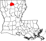
Livingston Parish 063 Livingston 1832 from part of St. Helena Parish. U.S. Secretary of State Edward Livingston 128,026 703 sq mi
(1,821 km2)
Madison Parish 065 Tallulah 1838 from Concordia Parish. U.S. President James Madison 12,093 651 sq mi
(1,686 km2)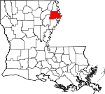
Morehouse Parish 067 Bastrop 1844 from parts of Carroll Parish and Ouachita Parish. Abraham Morehouse, who led the first settlers into the region 27,979 805 sq mi
(2,085 km2)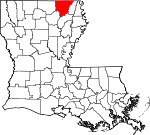
Natchitoches Parish 069 Natchitoches 1807 One of the original 19 parishes. The Natchitoches Native American people 39,566 1,299 sq mi
(3,364 km2)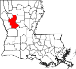
Orleans Parish 071 New Orleans 1807 One of the original 19 parishes. Today coterminous with the City of New Orleans. Named after the Duke of Orléans, the regent of France 343,829 907 sq mi
(2,349 km2)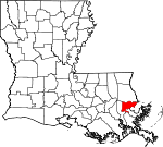
Ouachita Parish 073 Monroe 1807 One of the original 19 parishes. The Ouachita Native American people. 153,720 350 sq mi
(906 km2)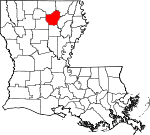
Plaquemines Parish 075 Pointe a la Hache 1807 One of the original 19 parishes. A word meaning persimmons created from the Louisiana Creole French and the Mobile Native American language 23,042 2,429 sq mi
(6,291 km2)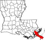
Pointe Coupee Parish 077 New Roads 1807 One of the original 19 parishes. French phrase la pointe coupée or in English, the cut-off point, which refers to a bend in the [Mississippi River]] 22,802 591 sq mi
(1,531 km2)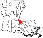
Rapides Parish 079 Alexandria 1807 One of the original 19 parishes. Named for local river rapids (French: rapides) 131,613 1,362 sq mi
(3,528 km2)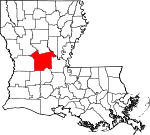
Red River Parish 081 Coushatta 1871 from parts of Bienville Parish, Bossier Parish, Caddo Parish and Natchitoches Parish. Named for Red River, which is part of the Mississippi River watershed 9,091 402 sq mi
(1,041 km2)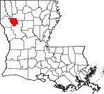
Richland Parish 083 Rayville 1868 from parts of Carroll Parish, Franklin Parish, Morehouse Parish and Ouachita Parish. Named for its rich land 20,725 564 sq mi
(1,461 km2)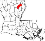
Sabine Parish 085 Many 1843 from parts of Caddo Parish and Natchitoches Parish. Named for the Sabine River and the so-called Sabine Free State 24,233 1,012 sq mi
(2,621 km2)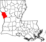
Saint Bernard Parish 087 Chalmette 1807 One of the original 19 parishes. Saint Bernard, who was presumably the patron saint of Bernardo de Galvez, the Spanish governor who granted land to the Canary Islanders who settled the area in 1778 while Louisiana was under Spanish rule. 35,897 1,794 sq mi
(4,646 km2)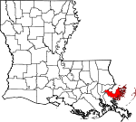
Saint Charles Parish 089 Hahnville 1807 One of the original 19 parishes. Saint Charles 52,780 410 sq mi
(1,062 km2)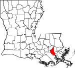
Saint Helena Parish 091 Greensburg 1810 from West Florida territory. Saint Helena 11,203 409 sq mi
(1,059 km2)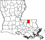
Saint James Parish 093 Convent 1807 One of the original 19 parishes. Saint James 22,102 258 sq mi
(668 km2)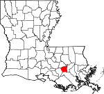
Saint John the Baptist Parish 095 Edgard 1807 One of the original 19 parishes. Saint John the Baptist 45,924 348 sq mi
(901 km2)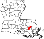
Saint Landry Parish 097 Opelousas 1807 One of the original 19 parishes. Saint Landry 83,384 939 sq mi
(2,432 km2)
Saint Martin Parish 099 Saint Martinville 1807 One of the original 19 parishes. Saint Martin 52,160 817 sq mi
(2,116 km2)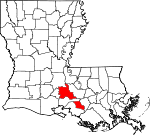
Saint Mary Parish 101 Franklin 1811 from part of St. Martin County. Saint Mary. 54,650 612 sq mi
(1,585 km2)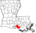
Saint Tammany Parish 103 Covington 1810 from West Florida territory. Legendary Indian Chief Tamanend. 233,740 1,124 sq mi
(2,911 km2)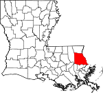
Tangipahoa Parish 105 Amite 1868 from parts of Livingston Parish, St. Helena Parish, St. Tammany Parish and Washington Parish. Comes from an Acolapissa word meaning ear of corn or those who gather corn 121,097 823 sq mi
(2,132 km2)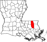
Tensas Parish 107 Saint Joseph 1843 from part of Concordia Parish. The Taensa Native American people. 5,252 641 sq mi
(1,660 km2)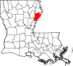
Terrebonne Parish 109 Houma 1822 from part of Lafourche Parish. French phrase terre bonne or in English, good earth 111,860 2,080 sq mi
(5,387 km2)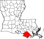
Union Parish 111 Farmerville 1839 from part of Ouachita Parish. Named for the union of states which make up the U.S. 22,721 905 sq mi
(2,344 km2)
Vermilion Parish 113 Abbeville 1844 from part of Lafayette Parish. Both the Vermilion River and Vermilion Bay 57,999 1,538 sq mi
(3,983 km2)
Vernon Parish 115 Leesville 1871 from parts of Natchitoches Parish, Rapides Parish and Sabine Parish. Mount Vernon, the home of George Washington, the first U.S. President 52,334 1,341 sq mi
(3,473 km2)
Washington Parish 117 Franklinton 1819 from part of St. Tammany Parish. U.S. President George Washington 47,168 676 sq mi
(1,751 km2)
Webster Parish 119 Minden 1871 from parts of Bienville Parish, Bossier Parish and Claiborne Parish. U.S. statesman Daniel Webster 41,207 615 sq mi
(1,593 km2)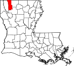
West Baton Rouge Parish 121 Port Allen 1807 One of the original 19 parishes. Was named Baton Rouge Parish until 1812. French phrase bâton rouge meaning red stick. A red stick was used by local Native Americans to mark the boundaries between tribal territories 23,788 203 sq mi
(526 km2)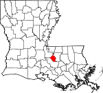
West Carroll Parish 123 Oak Grove 1877 when Carroll Parish was divided. Charles Carroll of Carrollton, the last surviving signer of the U.S. Declaration of Independence 11,604 360 sq mi
(932 km2)
West Feliciana Parish 125 Saint Francisville 1824 when Feliciana Parish was divided. Felicite de Gálvez, the wife of Bernardo de Gálvez, a Spanish governor of the Louisiana Territory 15,625 1,051 sq mi
(2,722 km2)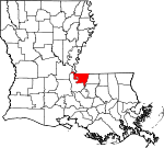
Winn Parish 127 Winnfield 1852 from parts of Catahoula Parish, Natchitoches Parish and Rapides Parish. Louisiana state legislator Walter Winn 15,313 957 sq mi
(2,479 km2)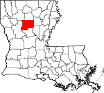
Former Parishes
- Biloxi Parish formed in 1811 from West Florida territory. It was eliminated in 1812 when part of the former West Florida area was transferred to Mississippi Territory.[1]
- Carroll Parish formed in 1838 from part of Ouachita Parish. In 1877, it was divided into East Carroll Parish and West Carroll Parish.[1]
- Feliciana Parish formed in 1810 from West Florida territory. In 1824, it was divided into East Feliciana Parish and West Feliciana Parish.[1]
- Pascagoula Parish formed in 1811 from West Florida territory. It was eliminated in 1812 when part of the former West Florida area was transferred to Mississippi Territory.[1]
- Warren Parish formed in 1811 from part of Concordia Parish, and merged into Concordia Parish and Ouachita Parish in 1814.[1]
Parishes
The thirteen parishes defined by the Territorial Legislative Council in 1803 were:
- Acadia Parish
- Attakapas Parish
- Concordia Parish
- German Coast Parish
- Iberville Parish
- Lafourche Parish
- Natchitoches Parish
- Opelousas Parish
- Orleans Parish
- Ouachita Parish
- Pointe Coupee Parish
- Rapides Parish
In addition, Feliciana Parish was established in 1810 from West Florida territory.
Fictional parishes
- In the novels Little Altars Everywhere, Divine Secrets of the Ya-Ya Sisterhood, and Ya-Yas in Bloom, author Rebecca Wells created the fictional "Garnet Parish".
- The movie Steel Magnolias was said to take place in the fictional "Chinquapin Parish", likely a suburban parish of Shreveport, Louisiana.
- Part of Walter Jon Williams' novel The Rift is set in the fictional Spottswood Parish.
- The Southern Vampire Mysteries series of novels written by Charlaine Harris and HBO's True Blood which is based on the novels take place in the fictional Northwestern Louisiana "Renard Parish".
- In the movie In the Electric Mist, Deputy Jason J. Bayard was from the fictional "St. Clare Parish".
References
- "Find a County". National Association of Counties. Archived from the original on 2006-11-08. http://web.archive.org/web/20061108043344/http://www.naco.org/Template.cfm?Section=Find_a_County&Template=/cffiles/counties/state.cfm&statecode=la. Retrieved 2007-03-13. - Counties, parish seats, areas, names and date of formation of current parishes
- "Louisiana County Formation Maps". http://www.n2genealogy.com/maps/la-maps.html. Retrieved 2007-03-13. - Formation dates and origin of parishes
- ^ a b c d e f Bryansite - Louisiana parishes
- ^ Louisiana Timeline - 1807
- ^ The Admission of Louisiana into the Union
- ^ "EPA County FIPS Code Listing". EPA.gov. http://www.epa.gov/enviro/html/codes/ar.html. Retrieved 2008-02-23.
- ^ a b c d National Association of Counties. "NACo - Find a county". http://www.naco.org/Template.cfm?Section=Find_a_County&Template=/cffiles/counties/state.cfm&state.cfm&statecode=la. Retrieved 2008-06-12.
- ^ Louisiana Dept. of Public Health Parish Profiles
External links
 State of Louisiana
Topics - Index
- History
- Music
- Louisianans
- Constitution
- Governors
- Lieutenant Governors
- Attorneys General
- Legislature
- Supreme Court
- Congressional Districts
- Symbols
- Visitor Attractions
Society Regions Cities CDPs Metros - Alexandria
- Baton Rouge
- Houma–Bayou Cane–Thibodaux
- Lafayette
- Lake Charles
- Monroe
- New Orleans
- Shreveport‑Bossier City
Parishes - Acadia
- Allen
- Ascension
- Assumption
- Avoyelles
- Beauregard
- Bienville
- Bossier
- Caddo
- Calcasieu
- Caldwell
- Cameron
- Catahoula
- Claiborne
- Concordia
- DeSoto
- East Baton Rouge
- East Carroll
- East Feliciana
- Evangeline
- Franklin
- Grant
- Iberia
- Iberville
- Jackson
- Jefferson
- Jefferson Davis
- La Salle
- Lafayette
- Lafourche
- Lincoln
- Livingston
- Madison
- Morehouse
- Natchitoches
- Orleans
- Ouachita
- Plaquemines
- Pointe Coupee
- Rapides
- Red River
- Richland
- Sabine
- St. Bernard
- St. Charles
- St. Helena
- St. James
- St. John the Baptist
- St. Landry
- St. Martin
- St. Mary
- St. Tammany
- Tangipahoa
- Tensas
- Terrebonne
- Union
- Vermilion
- Vernon
- Washington
- Webster
- West Baton Rouge
- West Carroll
- West Feliciana
- Winn
Categories:- Louisiana parishes
- Lists of U.S. counties by state
- Louisiana-related lists


Wikimedia Foundation. 2010.