- Dome Peak
-
Dome Peak 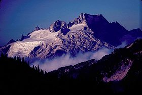
Elevation 8,920+ feet (2,719+ m) [1] Prominence 3,040 ft (927 m) [1] Location Location Skagit County, Washington, USA Range Cascade Range, North Cascades Coordinates 48°18′12″N 121°01′46″W / 48.303408442°N 121.029512500°WCoordinates: 48°18′12″N 121°01′46″W / 48.303408442°N 121.029512500°W[2] Topo map USGS Dome Peak Climbing First ascent August 1, 1936 by George Freed and Eric Larson 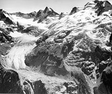 Chickamin Glacier, east face of Dome Peak (1965)
Dome Peak is a high, massive, glaciated mountain in the Glacier Peak Wilderness of Washington's North Cascades. The remote location of Dome Peak, combined with its height, make it a less common destination for Cascade Range mountaineers. Dome Peak is at the southern end of the Ptarmigan Traverse mountaineering route. It is located at the extreme southeast corner of Skagit County. The mountain was given its name by Albert H. Sylvester, the first forest supervisor of Wenatchee National Forest.
There are two main summits connected by a narrow ridge with the northeastern summit being higher than the southwestern.[2][3] Chickamin Glacier is north of the peak while Dome Glacier is to the west. A rock face drops off to the southeast. Dana Glacier is on the north side of a ridge that connects Dome Peak and Spire Point.
The higher northeast peak was first climbed by George Freed and Eric Larson on August 1, 1936.[3] The southwest peak was first climbed on July 5, 1936 by Forest Farr, Norval Grigg, and Don Blair.[4]
References
- ^ a b "Dome Peak, Washington". Peakbagger.com. http://www.peakbagger.com/peak.aspx?pid=1886. Retrieved 2009-01-19.
- ^ a b "Dome Peak". NGS data sheet. U.S. National Geodetic Survey. http://www.ngs.noaa.gov/cgi-bin/ds_mark.prl?PidBox=TQ0498.
- ^ a b Beckey, Fred W. (2003). Cascade Alpine Guide, Vol. 2, Stevens Pass to Rainy Pass (3rd ed.). Mountaineers Books. pp. 249–249. ISBN 0898868386.
- ^ Majors, Harry M. (1975). Exploring Washington. Van Winkle Publishing Co. p. 33. ISBN 9780918664006. http://books.google.com/books?id=CoWrPQAACAAJ.
External links
- "Dome Peak". Geographic Names Information System, U.S. Geological Survey. http://geonames.usgs.gov/pls/gnispublic/f?p=gnispq:3:::NO::P3_FID:1518853. Retrieved 2009-01-19.
- "Dome Peak". SummitPost.org. http://www.summitpost.org/page/150357. Retrieved 2011-05-07.
Categories:- Mountains of Washington (state)
- Landforms of Skagit County, Washington
- Washington (state) geography stubs


Wikimedia Foundation. 2010.