- Oregon Route 260
-
Oregon Route 260
Route information Maintained by ODOT Length: 20.84 mi (33.54 km) Existed: 2003 – present Major junctions West end:  US 199 near Grants Pass
East end: Upper River Road in Grants Pass Highway system Oregon highways
Routes • Highways←  OR 255
OR 273  →
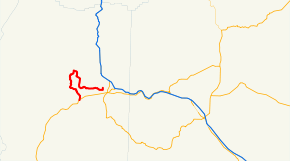
→Oregon Route 260 (OR 260) is an Oregon state highway running from the west side of Grants Pass to US 199 near Grants Pass. OR 260 is known as the Rogue River Loop Highway No. 260 (see Oregon highways and routes). It is 20.84 miles (33.54 km) long and runs in a half-loop from northeast to southwest, entirely within Josephine County.
OR 260 was established in 2003 as part of Oregon's project to assign route numbers to highways that previously were not assigned.
Contents
Route description
OR 260 begins at an intersection with Upper River Road at Grants Pass and heads west and north along the Rogue River before crossing the river and heading south to an intersection with US 199 approximately five miles southwest of Grants Pass, where it ends.
History
OR 260 was assigned to the Rogue River Loop Highway in 2003.
Major intersections
Milepost City Intersection 1.30 Grants Pass Begin Route 22.24 Near Grants Pass US 199 References
- Oregon Department of Transportation, Descriptions of US and Oregon Routes, http://www.oregon.gov/ODOT/HWY/TRAFFIC/TEOS_Publications/PDF/Descriptions_of_US_and_Oregon_Routes.pdf, page 22.
- Oregon Department of Transportation, Rogue River Loop Highway No. 260, ftp://ftp.odot.state.or.us/tdb/trandata/maps/slchart_pdfs_1980_to_2002/Hwy260_2001.pdf
Categories:- State routes in Oregon
- Transportation in Josephine County, Oregon


Wikimedia Foundation. 2010.