- Swakopmund
Infobox City |official_name = Swakopmund
|320px
image_
subdivision_type =Country
subdivision_type1 = Administrative Division
subdivision_name =Namibia
subdivision_name1 =Erongo
leader_title =Mayor
leader_name = Rosina Hoabes
established_title = Founded
established_date =August 4 ,1892
area_total_km2 =
area_total_sq_mi = 70
population_total = 35000
population_density_km2 =
population_density_sq_mi = 500
timezone =South African Standard Time
utc_offset = +1Swakopmund (German for "Mouth of the
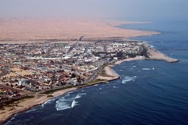
Swakop ") is acity on theAtlantic coast of northwesternNamibia , 280 km (175 miles) west ofWindhoek , Namibia's capital. It is the capital of theErongo administrative district. As a seaside resort, the weather is cooler here in December to January (Namibia's summer months) so the territorial administration moves to Swakopmund for these months. [cite web
url=http://www.britannica.com/eb/article-9070573/Swakopmund
title=Swakopmund
publisher=Encyclopedia Britannica
accessdate=2007-07-01 ] Swakopmund's population as of 2007 is approximately 28,552. [cite web
url=http://world-gazetteer.com/wg.php?x=&men=gpro&lng=en&dat=32&geo=-154&srt=npan&col=aohdq&pt=c&va=&geo=242407452
title=Swakopmund
publisher=World Gazetteer
accessdate=2007-07-01 ]Swakopmund is a
beach resort and an example of German colonial architecture. It was founded in 1892 as the mainharbour forGerman South-West Africa .Fact|date=September 2008The city lies on the B2 road and the
Trans-Namib Railway fromWindhoek toWalvis Bay . It is also home toSwakopmund Airport .Buildings in the city include the "Altes Gefängnis"
prison , designed byHeinrich Bause in 1909. TheWörmannhaus , built in 1906 with a prominent tower, is now apublic library .Attractions in Swakopmund include a
transport museum, the National Marine Aquarium, acrystal gallery and spectacularsand dune s nearLangstrand south of theSwakop River . Outside of the city, theRossmund Desert Golf Course is one of only 5 all-grass desert golf courses in the world. The city is known forextreme sports . Nearby lies acamel farm and the "Martin Luther "steam locomotive , dating from 1896 and abandoned in the desert.Name
The majority of towns and villages in Namibia have grown out of indigenous settlements and very often were located close to sources of water. Names of places given by original inhabitants were very descriptive and in many cases those names were retained by European
settler s who sometimes simplified pronunciations of the names. The Nama word "Tsoakhaub" can be translated as "excrement opening" which was an offensive but accurate description of the waters of theSwakop River when it flooded, carrying masses of mud, sand, pieces of vegetation and animal corpses to theAtlantic Ocean .The Nama name was changed to "Swachaub" by German settlers, and with the proclamation of Swakopmund as an independent district of German South-West Africa in 1896, the present way of writing Swakopmund (meaning "Estuary of the
Swakop " in German) came into use.History
Swakopmund was founded in 1892, two years later than
Windhoek , by CaptainCurt von François . It was intended to be the mainharbour ofGerman South-West Africa . Increased traffic betweenGermany and itscolony necessitated establishing a port of its own, asWalvis Bay , located 33 kilometres south, was in British possession. The choice fell to a site north of theSwakop River , because water was readily available, and because other sites were unsuitable. It should be noted however, that the site did not offer any natural protection to ships lying off the coast, such places being very rare on Namibia's western coast. [cite web
url=http://www.namibweb.com/swakopmund.htm
title=Swakopmund
publisher=NamibWeb.com
accessdate=2007-07-01 ]On 4 August 1892 the crew of a gunboat named "Hyäne" (German for
Hyena ) erected twobeacon s on a large dune, probably in the vicinity of the presentlighthouse . This is regarded as the founding date of Swakopmund. The first settlers were 120Schutztruppe with equipment and 40 settlers who offloaded from the "Marie Woermann" using four landing boats. The settlers had to build caves on the beach to protect themselves against hostile weather. Before a breakwater was built in 1898, which later became known as the Mole, all offloading was done with special boats that could only be handled byKroo men fromLiberia . At that time, up to 600 Kroo tribesmen were employed by theWoermann Line . The number of vessels offloading in Swakopmund was increasing rapidly. In 1894, only four ships offloaded, and in 1895 there were five. In 1896 the Woermann Line introduced bi-monthly service, and in 1899, monthly service to Swakopmund. Due to a lack of building materials, most of the first settlers' houses were prefabricated wood.Swakopmund quickly became the main port for imports and exports for the whole territory, and was one of six towns which received municipal status in 1909. Many government offices for German South-West Africa had offices in Swakopmund.Soon, the harbour created by the Mole silted up, and in 1905 work was started on a wooden jetty, but in the long run this was inadequate. In 1914 construction of an iron jetty was therefore commenced, the remains of which can still be seen today. After
World War I it became a pedestrian walkway. It was declared structurally unsound and was closed to the public for seven years and in 2006 renovations to the portion supported by concrete pillars was completed with the remaining portion being alienated. It was opened to the public once more in late 2006. Trading and shipping companies founded branches in Swakopmund. A number of these buildings still exist today. After German South-West Africa was taken over by theUnion of South Africa in 1915, all harbour activities were transferred from Swakopmund to Walvis Bay. Many of the Central Government services ceased. Businesses closed down, the number of inhabitants diminished, and the town became less prosperous. However, the natural potential of Swakopmund as a holiday resort was recognised, and this potential has subsequently been developed. Today tourism-related services form an important part of the town's economy.The discovery of
uranium atRössing , 70 km (43 mi) outside the town, led to the development of the world's largest opencast uranium mine. This had an enormous impact on all facets of life in Swakopmund which necessitated expansion of the infrastructure of the town to make it into one of the most modern in Namibia.In October 2000 an agreement was signed between the Namibian and
People's Republic of China governments to build asatellite tracking station at Swakopmund. Construction was completed in July 2001 at a site north of Swakopmund to the east of the Henties Bay-Swakopmund road and opposite the Swakopmund Salt Works. The site was chosen as it was on the orbital track of a manned spacecraft during its reentry phase. Costing N$12 million, the complex covers 150m by 85m. It is equipped with five meter and nine meter satellite dishes.In August 2008 filming commenced in Swakopmund on the
AMC television series "The Prisoner" starringJim Caviezel and SirIan McKellen . [cite web
url=http://www.amctv.com/originals/the-prisoner/
title="The Prisoner"
publisher=AMC website
accessdate=2008-09-23]Climate
Surrounded by the
Namib Desert on three sides and the cold Atlantic waters to the west, Swakopmund enjoys a temperate climate. The average temperature ranges between 15°C (59°F) to 25°C (77°F). Rainfall is less than 15 mm per year, making gutters and drainpipes on buildings a rarity. The coldBenguela current supplies moisture for the area in the form offog that can reach as deep as 140 km (87 mi) inland. The fauna and flora of the area has adapted to this phenomenon and now relies upon the fog as a source of moisture.Notable inhabitants
*
Shiloh Jolie-Pitt , daughter ofBrad Pitt andAngelina Jolie was born here
*Austin Stevens Fact|date=March 2008ee also
*
Rössing
*Namib Desert Footnotes
External links
* [http://www.water-technology.net/projects/swakopmund/ Swakomund Desalination Plant]
* [http://www.swkmun.com.na/ City of Swakopmund Website]
* [http://www.namibia-1on1.com/Namibia-Map/Swakopmund-Map-01.html Map of Swakopmund city]
* [http://www.swkmun.com.na/map.htm Map locating Namibia and Swakopmund]
* [http://weather.msn.com/local.aspx?wealocations=wc:WAXX0002 Swakopmund weather forecast]
Wikimedia Foundation. 2010.