- North Arm Cove, New South Wales
-
North Arm Cove
New South WalesPopulation: 364[1] Postcode: 2324 Coordinates: 32°37′31″S 152°02′39″E / 32.62528°S 152.04417°ECoordinates: 32°37′31″S 152°02′39″E / 32.62528°S 152.04417°E Time zone: • Summer (DST)
AEST (UTC+10) AEDT (UTC+11)
Location: - 203 km (126 mi) NNE of Sydney
- 63 km (39 mi) NNE of Newcastle
- 106 km (66 mi) SSW of Forster-Tuncurry
- 19 km (12 mi) W of Tea Gardens
LGA: Great Lakes Council[2] Region: Hunter,[2] Mid North Coast County: Gloucester[3] Parish: Mount George[3] State District: Port Stephens[4] Federal Division: Paterson[5] Mean max temp Mean min temp Annual rainfall 27.3 °C
81 °F8.4 °C
47 °F1,348.9 mm
53.1 inSuburbs around North Arm Cove: The Branch The Branch Nerong Karuah, Carrington North Arm Cove Tea Gardens, Pindimar, North Arm Cove Port Stephens Port Stephens Port Stephens North Arm Cove is a suburb of the Great Lakes Council Local Government Area in the Hunter and Mid North Coast regions of New South Wales, Australia, located adjacent to Port Stephens and extending well north of the Pacific Highway.[2][3][6]. The suburb is sparsely populated with most of the population living in the southern portion of the suburb.
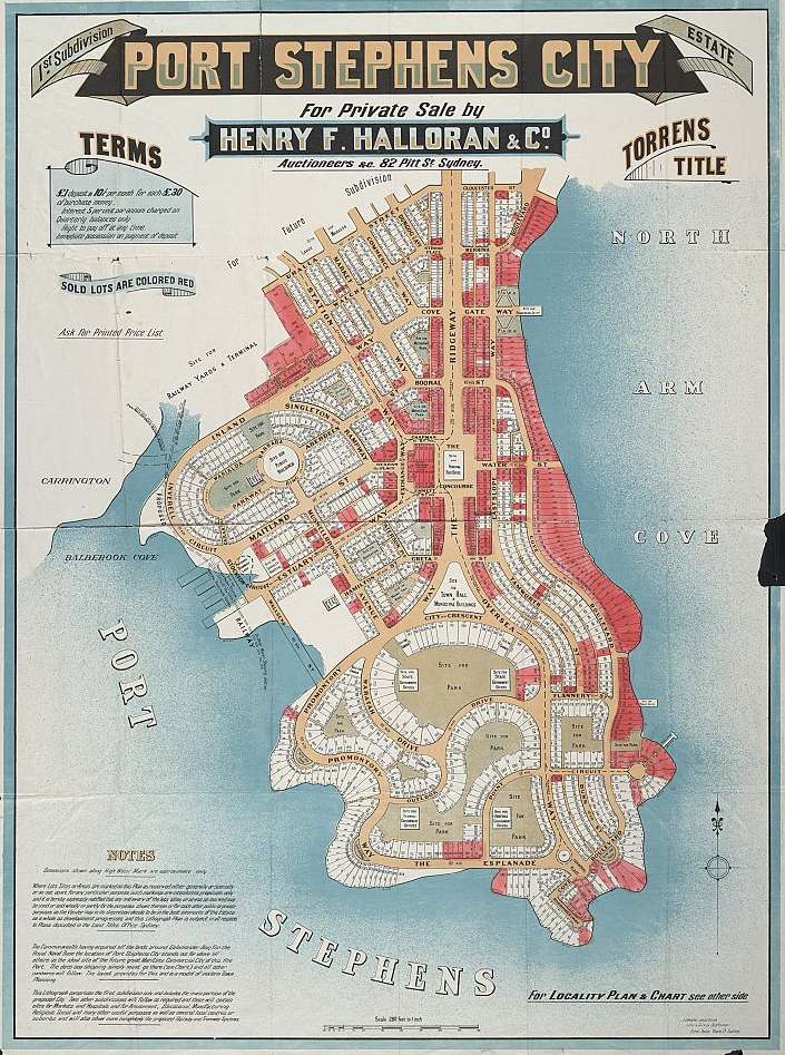
It was under consideration as a possible site for the national capital before Canberra was chosen and has many dirt roads laid out in the bushland that date from the original subdivision in 1918.[6][7]
Contents
Land use
1918 subdivision
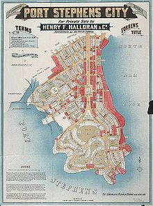 1920 advertisement for subdivisions in "Port Stephens City".
Land from the 1918 subdivision is zoned "non-urban", meaning that construction of buildings is not permitted under any circumstances.[8] Because of this, land sales at North Arm Cove have been the subject of controversy for many years, even being raised as a matter in the NSW Parliament.[8][9] Despite this, many blocks are purchased as investment properties and/or for use as weekend retreats. However, land is regularly sold and resold as owners become frustrated with being unable to develop their properties.[10][9]
Land use today
Restrictions on land use in the area has meant that a limited number of residential blocks are available and the suburb's population is concentrated mainly in the village of North Arm Cove, which is located on the western shore of North Arm cove itself, and the northern shore of Port Stephens. Many of the small houses that used to be in the area have been torn down and replaced with more expensive, modern homes.
To the north of the Pacific Highway, land use is mainly rural and throughout the suburb kangaroos, wallabies and koalas are commonly found. A Club Med resort was to be built however local objection has halted the plan.[citation needed]
References
- ^ Australian Bureau of Statistics (25 October 2007). "North Arm Cove (L) (Urban Centre/Locality)". 2006 Census QuickStats. http://www.censusdata.abs.gov.au/ABSNavigation/prenav/LocationSearch?collection=Census&period=2006&areacode=UCL161080&producttype=QuickStats&breadcrumb=PL&action=401. Retrieved 2008-07-09. Map
- ^ a b c "Suburb Search - Local Council Boundaries - Hunter (HT) - Great Lakes Council". New South Wales Department of Local Government. http://www.dlg.nsw.gov.au/dlg/dlghome/dlg_Regions.asp?regiontype=2&slacode=3400®ion=HT. Retrieved 2008-07-09.
- ^ a b c "Geographical Names Register Extract: North Arm Cove (locality)". Geographical Names Register (GNR) of NSW. Geographical Names Board of New South Wales. http://www.gnb.nsw.gov.au/name_search/extract?id=MnKqXtsEan. Retrieved 2008-07-09.
- ^ "Port Stephens". New South Wales Electoral Commission. 2007-03-24. http://www.elections.nsw.gov.au/state_government_elections/electoral_districts/all_districts_/port_stephens. Retrieved 2008-07-09.
- ^ "Paterson". Australian Electoral Commission. 2007-10-19. http://apps.aec.gov.au/esearch/LocalitySearchResults.aspx?filter=Paterson&filterby=Electorate. Retrieved 2008-07-09.
- ^ a b "North Arm Cove". Land and Property Management Authority - Spatial Information eXchange. New South Wales Land and Property Management Authority. http://imagery.maps.nsw.gov.au/?role=mysuburb&search=suburb&suburb=North%20Arm%20Cove. Retrieved 2008-07-09.
- ^ "History of Port Stephens". http://www.portstephens-australia.com/history.php. Retrieved 2008-07-09. (see "North Arm Cove")
- ^ a b "Advice on Land at NORTH ARM COVE". Great Lakes Council. 2007-08-28. http://www.greatlakes.local-e.nsw.gov.au/planning/11512/11514.html. Retrieved 2008-07-13.[dead link];
"Information Regarding 1(A) Rural Land Without Dwelling Entitlements in North Arm Cove, Pindimar, Bundabah, Carrington Localities" (PDF). Great Lakes Council. http://www.greatlakes.local-e.nsw.gov.au/files/11513/File/FACTSHEET_1anonurbanland.pdf. Retrieved 2008-07-13.[dead link] - ^ a b "North Arm Cove Land Sales". Parliament of New South Wales. 1998-05-27. http://www.parliament.nsw.gov.au/prod/parlment/HansArt.nsf/V3Key/LC19980527026. Retrieved 2008-07-13.
- ^ "North Arm Cove, Port Stephens, NSW Real Estate". domain.com.au. http://www.domain.com.au/real-estate/nsw/port+stephens/north+arm+cove/26.html. Retrieved 2008-07-13.;
"Tea gardens Real Estate (Land at North Arm Cove)". Tea Gardens Real Estate. http://www.teagardensrealestate.com.au/xdb?db=TGRE&mod=site-REsearch1&Location=North%20Arm%20Cove&Type=Land&norent=&cat=. Retrieved 2008-07-13.
- "Nelson Bay (Nelson Head)". Climate statistics for Australian locations. Bureau of Meteorology. http://www.bom.gov.au/climate/averages/tables/cw_061054.shtml. Retrieved 2008-07-09.
Towns, suburbs and localities of Great Lakes Council | Hunter & Mid North Coast Regions | New South Wales Towns, suburbs
& localitiesAllworth • Bulahdelah • Bungwahl • Dungog • Failford • Forster • Hawks Nest • Karuah • Monkerai • Nabiac • North Arm Cove • Pacific Palms • Seal Rocks • Smiths Lake • Stroud • Tahlee • Tea Gardens • Tuncurry
Other places &
points of interestBooti Booti National Park • Broughton Island • Cape Hawke • Ghin-Doo-Ee National Park • Karuah River • Manning River • Myall Lakes • Myall Lakes National Park • Myall River • Port Stephens • Singing Bridge • Tahlee historic property • Tops to Myall Heritage Trail • Wallingat National Park
Categories:- Suburbs of Great Lakes Council
Wikimedia Foundation. 2010.