- List of crossings of the Ochlockonee River
-
Contents
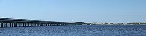 Ochlockonee Bay Bridge
This is a list of bridges and other crossings of the Ochlockonee River.
-
This transport-related list is incomplete; you can help by expanding it.
Crossings
Crossing Carries Location Coordinates Georgia
 GA 270
Doerun  GA 133
Sigsbee Old Doerun Rd Moultrie  GA 111
Moultrie  GA 37
GA 37Moultrie  GA 188
 GA 202
 US 19
US 19
 GA 300
Dawesville Rail bridge CSX Dawesville  GA 3
GA 3Dawesville  US 84
US 84
 GA 38
GA 38Rail bridge CSX  GA 93
GA 93Cairo (road unknown) Rocky Hill Florida
Fairbanks Ferry Bridge  FL 12
FL 12Concord Leon CR 0361
Gadsden CR 157Tallahassee  US 27
US 27Tallahassee Rail bridge CSX Tallahassee  Interstate 10
Midway  US 90
US 90Midway Rail bridge CSX Midway Talquin Dam Bloxham  FL 20
FL 20
 FL 267
Bloxham Wakulla CR 368
Forest Highway 13Porter Lake  US 319
Sopchoppy Ochlockonee Bay Bridge  US 98
US 98Ochlockonee Bay References
- http://www.dot.state.fl.us/statemaintenanceoffice/CBR/Florida%20Bridge%20Information%2001-05-2009.pdf Florida Dept. of Transportation, Florida Bridge InformationPDF
See also
- List of crossings of the Aucilla River
- List of crossings of the Halifax River
- List of crossings of the St. Johns River
- List of crossings of the Suwannee River
Categories:- Bridges in Florida
- Bridges in Georgia (U.S. state)
- Transportation in Wakulla County, Florida
- Crossings by river
- Lists of river crossings in the United States
-

Wikimedia Foundation. 2010.