- City of Gladstone
-
City of Gladstone
Queensland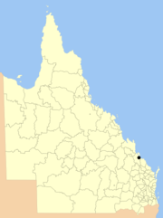
Location within QueenslandPopulation: 26,719 Area: 147 km² (56.8 sq mi) Council Seat: Gladstone 
LGAs around City of Gladstone: Pacific Ocean Pacific Ocean Pacific Ocean Calliope City of Gladstone Pacific Ocean Calliope Calliope Pacific Ocean City of Gladstone is a Local Government Area in central Queensland, Australia. The LGA covers the urban locality of Gladstone and parts of the surrounding area.
Being a port city, its local commerce is primarily industrial-based and include large-scale industrial plants include alumina refineries, aluminium smelting, heavy chemicals and shale oil.
The City of Gladstone recently amalgamation with the Shire of Calliope; and Shire of Miriam Vale on the 15 March 2008 as a result of the report of the Local Government Reform Commission released in July 2007.
Contents
Facilities
Hospital
Gladstone does contain a hospital, providing a range of facilities including: Emergency, Outpatients, General Medicine and Surgery (including Day Surgery (including Day Surgery), basic Orthopaedics, Obstetrics and Gynaecology, Medical Imaging, Pharmacy, Pathology, Central Sterilising.
These services are limited, thus requiring referral to the closest major city (Rockhampton Hospital 110km away).
Art Gallery
Gladstone does contain an art gallery run and owned by the Gladstone Regional Council.
Airport
Gladstone Regional Council does contain an airport. The Council took control of the assets of the Gladstone Airport which was previously operated by the Gladstone Calliope Aerodrome Board. This Board was a statutory body made up of representatitves of the City of Gladstone and Shire of Calliope. It is currently being refurbished and provides both indirect and direct flights only to Brisbane Airport. These services are provided by Quantas Link and Strategic Airlines (as of April 2011).
See also
External links
- Queensland Department of Local Government & Planning - Local Government Directory.
- [1] - Queensland Government: Queensland Health 2010
Local Government Areas of Queensland South East Brisbane · Gold Coast · Ipswich · Lockyer Valley · Logan · Moreton Bay · Redland · Scenic Rim · Somerset · Sunshine CoastWide Bay-Burnett Darling Downs Central Central Highlands · Gladstone · Isaac · Mackay · Rockhampton · WoorabindaNorth Far North Aurukun · Cairns · Cassowary Coast · Cook · Hopevale · Kowanyama · Lockhart River · Mapoon · Napranum · Northern Peninsula Area · Pormpuraaw · Tablelands · Torres · Torres Strait Islands · Weipa · Wujal Wujal · YarrabahNorth West Central West South West Coordinates: 23°50′55.36″S 151°15′35.30″E / 23.8487111°S 151.259806°E
Categories:- Former Local Government Areas of Queensland
- Queensland geography stubs

Wikimedia Foundation. 2010.