- Miyashiro, Saitama
-
Miyashiro
宮代町— Town — Location of Miyashiro in Saitama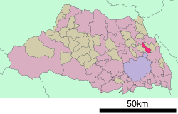

 Miyashiro
Coordinates: 36°1′N 139°43′E / 36.017°N 139.717°ECoordinates: 36°1′N 139°43′E / 36.017°N 139.717°E Country Japan Region Kantō Prefecture Saitama District Minamisaitama Area – Total 15.95 km2 (6.2 sq mi) Population (2005) – Total 34,620 – Density 2,170.5/km2 (5,621.7/sq mi) Time zone Japan Standard Time (UTC+9) Website Town of Miyashiro Miyashiro (宮代町 Miyashiro-machi) is a town located in Minamisaitama district, Saitama, Japan.
As of 2005, the town has an estimated population of 34,620. The total area is 15.95 km². The average age of Miyashiro residents is 42.
Historically, Miyashiro was created from the joining of neighboring villages in 1955 and thus the commercial and population centers are still centered around these older districts. The origin of the town's name comes from the shrines of the largest villages. "Miya" was taken from Himemiya shrine (姫宮神社) in Himemiya village and "shiro" from Konoshiro shrine (身代神社) in Suka village.
Miyashiro is best known among Tokyoites for its zoological-amusement park complex Tōbu Zoo (東武動物公園 Tōbu Dōbutsu Kōen), which is owned by the Tōbu Group.
There are two train lines that run through the town, which are also owned by Tobu, the Isesaki Line and the Nikkō Line. Miyashiro has three train stations from south to north: Himemiya, Tōbu Dōbutsu Kōen and Wado. Tōbu Dōbutsu Kōen Station, named after the zoo, is the main stop and in the heart of Miyashiro.
Miyashiro's largest neighboring city is Kasukabe on the south.
External links
 Media related to Miyashiro, Saitama at Wikimedia Commons
- Miyashiro official website (Japanese)
Categories:- Towns in Saitama Prefecture
- Saitama geography stubs


Wikimedia Foundation. 2010.