- Texas State Highway 326
Infobox TX State Highway
type=SH
route=326
maint=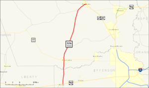
length_mi=24.372
length_ref=TxDOT|SH|326|accessdate=2008-04-02]
length_round=3
length_notes=
formed=1940
dir1=South
dir2=North
from=jct|state=TX|US|90|SH|365 in Nome
junction=
to=jct|state=TX|US|69|US|287 in Kountze
previous_type=SH
previous_route=325
next_type=SH
next_route=327State Highway 326, abbreviated SH 326, is a convert|24.372|mi|km|3|sing=on
state highway in theU.S. state ofTexas . The highway begins at a junction with U.S. Highway 90 (US 90) and SH 365 in Nome and heads north to a junction with U.S. Highway 69 and US 287 in Kountze.History
SH 326 was designated in 1940 to serve as a route between Sour Lake and Kountze. In 1943, the route was extended to the south to Nome
Route description
SH 326 begins in
East Texas at a junction with US 90 and SH 365 in Nome. It heads north from this junction to an intersection with SH 105 in Sour Lake. The highway continues to the north to an intersection with FM 421. Heading north, the highway continues to an junction with FM 770. The highway intersects FM 1293 as it enters the Kountze city limits. SH 326 reaches its northern terminus at US 69 and US 287 in Kountze.cite map|publisher=Google Maps |title=Overview map of SH 326|accessdate=2008-04-02|url=http://maps.google.com/maps?f=d&hl=en&geocode=10332001543433704364,30.037800,-94.407990%3B8637756087127807361,30.369424,-94.311941&saddr=TX-326+%4030.037800,+-94.407990&daddr=TX-326+%4030.369424,+-94.311941&doflg=ptm&sll=30.20361,-94.36&sspn=0.378011,0.38]Junction list
References

Wikimedia Foundation. 2010.