- Monegeetta, Victoria
-
Monegeetta
Victoria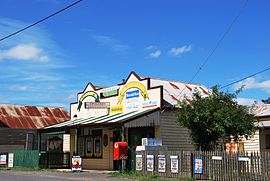
General store, Monegeetta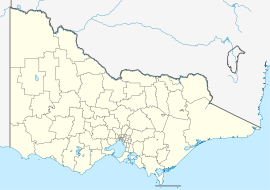
 Monegeetta
Population: 382 (2001 census) Postcode: 3433 Elevation: 415 m (1,362 ft) Location: LGA: Shire of Macedon Ranges State District: Macedon Federal Division: McEwen Localities around Monegeetta: Kerrie Romsey Springfield Kerrie Monegeetta Chintin Riddells Creek Bolinda Chintin Monegeetta (pronounced /ˈmɒnəɡiːtə/) is a town north of Melbourne, Australia, located between the major towns of Sunbury and Romsey in fertile agricultural land east of the Macedon Ranges. Its local government area is the Shire of Macedon Ranges.
Contents
History
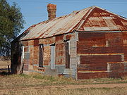 The former Duckholes Hotel at Monegeetta North
The Post Office opened on 23 January 1911 as Monegatta South, was renamed Monegeeta (sic) in 1917 then Monegeetta around 1960 and closed in 1992. Another office nearby, Duck Holes, had opened in 1866, was renamed Monegatta in 1875, North Monegeeta in 1917, North Monegeetta around 1961 and closed in 1969. [1]
Monegeetta North, occasionally referred to as Duckholes, was historically a distinct locality, once featuring its own Hotel (1862-1896) and State school (1868-1903). The former Hotel building remains as a local landmark for travellers on the Melbourne-Lancefield Road.[2]
Both Monegeetta and North Monegeetta were stopping points on the Clarkefield-Lancefield railway which operated between 1881 and 1956.
Today
Monegeetta features Mintaro Homestead (1882), a smaller replica of Melbourne's Government House built by a Captain Gardiner.
The Land Engineering Agency (LEA) of the Australian Department of Defence operates a heavy vehicle testing course near the town.
The town contains a CFA fire station and general store, and a private bus company operates a commuter bus service to Melbourne for residents from Monday to Friday.
References
- ^ Premier Postal History. "Post Office List". https://www.premierpostal.com/cgi-bin/wsProd.sh/Viewpocdwrapper.p?SortBy=VIC&country=. Retrieved 2008-04-11
- ^ Mitchell, Peter; Alan Jackson, Carol Moore, Gavin Smith (2004). Romsey: A Veritable Garden of Eden. Romsey: West Bourke Books Inc. ISBN 0-646-43570-1.
External links
- Monegeetta, Victoria is at coordinates 37°24′47″S 144°44′56″E / 37.413°S 144.749°ECoordinates: 37°24′47″S 144°44′56″E / 37.413°S 144.749°E
Towns and localities in the Shire of Macedon Ranges
(major towns in bold)Ashbourne · Baynton · Bolinda · Bullengarook · Carlsruhe · Cherokee · Clarkefield · Cobaw · Darraweit Guim · Gisborne · Gisborne South · Hesket · Kerrie · Kyneton · Lancefield · Lauriston · Macedon · Malmsbury · Monegeetta · Monegeetta North · Mount Macedon · New Gisborne · Newham · Riddells Creek · Rochford · Romsey · Springfield · Tylden · Woodend · Woodend North
Categories:- Towns in Victoria (Australia)
- Macedon Ranges
- Victoria (Australia) geography stubs
- Australian military stubs


Wikimedia Foundation. 2010.