- Hankensbüttel (Samtgemeinde)
Infobox Town DE
name = Samtgemeinde Hankensbüttel
name_local = Hankensbuettel
image_coa = Hankensbüttelsamtgemwappen.jpg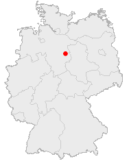
state =Lower Saxony
regbzk =
district = Gifhorn
population = 9,739
population_as_of = 2005
population_ref =
pop_dens = 34
area = 290.27
elevation =
lat_deg = 52
lat_min = 43
lat_hem = N
lon_deg = 10
lon_min = 35
lon_hem = E
postal_code = 29365, 29367, 29386
area_code = 05832
licence = GF
mayor = Werner Rodewald (Independent)
website = [http://www.sg-hankensbuettel.de/ SG-Hankensbuettel.de]Samtgemeinde Hankensbüttel is a
Samtgemeinde in the district of Gifhorn, inLower Saxony ,Germany . It is situated approx. 30 km north-east ofGifhorn and 20 km north ofUelzen . 9.739 citizens are living in the Samtgemeinde Hankensbüttel.Politics
amtgemeinde council
* CDU - 13 Seats
*SPD - 4 Seats
* Green Party - 3 Seats
* FDP - 1 Seat
* Independent - 3 Seatstructure of Samtgemeinde Hankensbüttel
Samtgemeinde Hankensbüttel was founded with five member municipalities. The administration of Papenteich is situated in the central village of
Hankensbüttel .Economy
The Samtgemeinde Hankensbüttel is a rural area with many forests and agriculture. Also, there are some areas of
heathland that make part of theLüneburger Heide . The biggest employer of the region isVolkswagen atWolfsburg , that is 50 km away from Hankensbüttel. Furthermore, there is some tourism in the region (see below).Tourism
There are some touristical sights in the Samtgemeinde Hankensbüttel: Directly at Hankensbüttel is the Otter-Zentrum (otter-centre), a zoo of local animals, and a monastery built in the time from 1345 to 1350. At Oerrel, there is a museum of hunting. Around the villages, there are forests and some areas of
heathland which make part of the national parkSüdheide . The streets and the flat countryside are ideal for bicycle tours.External links
* [http://www.sg-hankensbuettel.de/ Webpage of Samtgemeinde]
Wikimedia Foundation. 2010.