- Tahaa
French commune|nomcommune=Tahaa
map_size=300px
adjustable_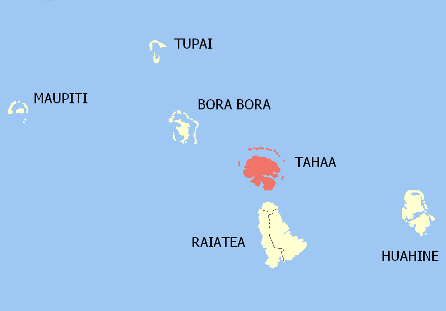
mapcaption=Location of the commune (in red) within the Leeward Islands
overseas collectivity=French Polynesia
lat_long=
administrative subdivision=Leeward Islands
commune centre=Patio
insee=98745
cp=98733
mayor=Ismaël Tuahu
|mandat=
longitude=|latitude=
alt moy=|alt mini=0 m|alt maxi=590 m
km²=90.2
sans=5,003
date-sans=Aug. 2007 census
dens=55|date-dens=2007 census|Tahaa (see footnote for variant spellings) is an island located among the
Society Islands , inFrench Polynesia , an overseas territory ofFrance in thePacific Ocean . The islands of Tahaa and neighboringRaiatea are enclosed by the samecoral reef , and may once have been a single island.Administratively speaking, Tahaa and the surrounding
islet s emerging from the coral reef form a commune (municipality) part of the administrative subdivision of the Leeward Islands. The administrative centre of the commune of Tahaa is the settlement of Patio.Tahaa produces 70-80% of all French Polynesia's
vanilla . Because of the pervasive aroma of vanilla, Tahaa is known as the "Vanilla Island". Tahaa'spearl s are of exceptional quality.Taha'a and its small motus (islets) can be reached by boat and outrigger from Raiatea. The short sail drops visitors on a motu beach with a perfect small lagoon, and in the near distance, a view of Bora Bora framed by the coconut palms and the lagoon. This is a short day trip to a more simple Tahiti.
Note
The name Tahaa is sometimes spelled Taha’a in Tahitian, using the apostrophe (in fact a variant of it hard to differentiate from the regular apostrophe when using small fonts) to represent the
glottal stop , as promoted by the "Académie Tahitienne" and accepted by the territorial government [http://www.farevanaa.pf/theme_detail.php?id=5] . This apostrophe, however, is often omitted. In old travelogues, thetranscription Oataha is sometimes used.
Wikimedia Foundation. 2010.