- Majors Airport
-
Majors Airport 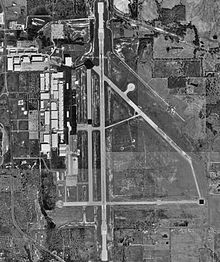
USGS aerial image - 21 February 1995 IATA: GVT – ICAO: KGVT – FAA LID: GVT Summary Airport type Public Owner City of Greenville Serves Greenville, Texas Elevation AMSL 535 ft / 163 m Coordinates 33°04′04″N 096°03′55″W / 33.06778°N 96.06528°WCoordinates: 33°04′04″N 096°03′55″W / 33.06778°N 96.06528°W Runways Direction Length Surface ft m 17/35 8,030 2,448 Asphalt Statistics (2007) Aircraft operations 35,640 Based aircraft 39 Source: Federal Aviation Administration[1] 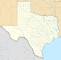
 Majors AirportLocation of Majors Airport, Texas
Majors Airport (IATA: GVT, ICAO: KGVT, FAA LID: GVT) is a city-owned, public-use airport located four nautical miles (7 km) southeast of the central business district of Greenville, a city in Hunt County, Texas, United States.[1]
Originally named Majors Field, is mostly used for general aviation, but is also home to an L-3 Communications facility that is used to modify aircraft.
Contents
History
Majors Airport, named for Lieutenant Truett Majors, the first Hunt County native to perish in World War II, began operations on June 26, 1942, as a training center for the United States Army Air Forces. Lt Majors was killed in the 1942 Battle of the Philippines in January 1942. Greenville was chosen as a site for the USAAF basic flight-training center due to the efforts of the influential politician Sam Rayburn, the base was formally dedicated and named on 5 January 1943.
Majors Army Airfield was assigned initially to the Gulf Coast Training Center (later Central Flying Command), the airport was at one point the home to approximately 5,000 pilots, support personnel, and civilian employees. Majors also was a major training base for Women Airforce Service Pilots (WASP)s. Flying training was performed with Fairchild PT-19s as the primary trainer. Also had several PT-17 Stearmans and a few P-40 Warhawks assigned.
In addition to training United States Army pilots, the airfield was the training site for Escuadrón 201 of the Mexican Air Force. The training center was reassigned to Second Air Force on 30 November 1944 as a group training center, primary for the assignment of replacement personnel to combat squadrons in Overseas theaters.
Majors AAF was inactivated on 18 July 1945 after the defeat of Germany; the city of Greenville then took ownership of the property, then leased the site to TEMCO (later L-3 Communications).
Facilities and aircraft
Majors Airport covers an area of 1,525 acres (617 ha) at an elevation of 535 feet (163 m) above mean sea level. It has one runway designated 17/35 with an asphalt surface measuring 8,030 by 150 feet (2,448 x 46 m).[1]
For the 12-month period ending April 30, 2007, the airport had 35,640 aircraft operations, an average of 97 per day: 92% general aviation and 8% military. At that time there were 39 aircraft based at this airport: 90% single-engine and 10% multi-engine.[1]
See also
References
Other sources
 This article incorporates public domain material from websites or documents of the Air Force Historical Research Agency.
- Shaw, Frederick J. (2004), Locating Air Force Base Sites History’s Legacy, Air Force History and Museums Program, United States Air Force, Washington DC, 2004.
- Manning, Thomas A. (2005), History of Air Education and Training Command, 1942–2002. Office of History and Research, Headquarters, AETC, Randolph AFB, Texas ASIN: B000NYX3PC
- Thole, Lou (1999), Forgotten Fields of America : World War II Bases and Training, Then and Now - Vol. 2. Publisher: Pictorial Histories Pub, ISBN 1575100517
External links
- Majors Airport Homepage
- FAA Terminal Procedures for GVT, effective 20 October 2011
- Resources for this airport:
- AirNav airport information for KGVT
- ASN accident history for GVT
- FlightAware airport information and live flight tracker
- NOAA/NWS latest weather observations
- SkyVector aeronautical chart, Terminal Procedures for KGVT
 Army Air Forces Training Command
Flying Training Flying Schools Eastern Flying Training Command · Central Flying Training Command · Western Flying Training CommandSpecialized Schools Bombardier · Contract Flying · Glider Training · Gunnery · Navigator
Technical Training Eastern Technical Training Command · Central Technical Training Command · Western Technical Training CommandCategories:- 1942 establishments
- Airfields of the United States Army Air Forces in Texas
- Airports in Texas
- Airports in the Dallas-Fort Worth Metroplex
- Buildings and structures in Hunt County, Texas
- USAAF Gulf Coast Training Center
- Transportation in Hunt County, Texas


Wikimedia Foundation. 2010.