- Chesham, New Hampshire
-
Chesham Village District

Location: Harrisville, NH
Roughly bounded by Yellow Wings, Seaver, Chesham, and Marienfield RdsCoordinates: 42°55′50″N 72°8′55″W / 42.93056°N 72.14861°WCoordinates: 42°55′50″N 72°8′55″W / 42.93056°N 72.14861°W MPS: Harrisville MRA NRHP Reference#: 86003102 Added to NRHP: December 29, 1986 Chesham is a village within the town of Harrisville in Cheshire County, New Hampshire, United States. The village is listed on the National Register of Historic Places.[1]
Chesham has an elementary school called Wells Memorial School. It has about 55 pupils up to grade 6.
The Community Church of Harrisville and Chesham was formed from Chesham Baptist Church and Harrisville Congregational Church. Chesham Baptist Church dates back to 1785. The church building was originally built in 1797, re-modeled in 1830, and again re-modeled in 1844.
References
- ^ "National Register of Historic Places - NPS Focus". National Register of Historic Places. National Park Service. 2009-11-09. http://nrhp.focus.nps.gov/natreghome.do?searchtype=natreghome/.
Municipalities and communities of Cheshire County, New Hampshire County seat: Keene City 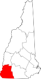
Towns Alstead | Chesterfield | Dublin | Fitzwilliam | Gilsum | Harrisville | Hinsdale | Jaffrey | Marlborough | Marlow | Nelson | Richmond | Rindge | Roxbury | Stoddard | Sullivan | Surry | Swanzey | Troy | Walpole | Westmoreland | Winchester
Villages Ashuelot | Chesham | Drewsville | East Swanzey | North Walpole | Poocham | Spofford | West Swanzey
Categories:- Historic districts in New Hampshire
- Unincorporated communities in New Hampshire
- National Register of Historic Places in New Hampshire
- Populated places in Cheshire County, New Hampshire


Wikimedia Foundation. 2010.