- Sherman Army Airfield
Infobox Airport
name = Sherman Army Airfield
nativename =
nativename-a =
nativename-r =
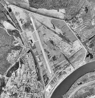
image-width =
caption =
IATA = FLV
ICAO = KFLV
type = Military/Public
owner =
operator =
city-served =
location = Leavenworth
elevation-f = 772
elevation-m = 235.3
coordinates = Coord|39|22|06|N|94|54|53|W|type:airport|display=inline,title
website =
metric-elev =
metric-rwy =
r1-number = 15/33
r1-length-f = 5,905
r1-length-m = 1,800
r1-surface = Asphalt/Concrete
stat-year =
stat1-header =
stat1-data =
stat2-header =
stat2-data =
footnotes =Sherman Army Airfield Airport codes|FLV|KFLV is an
airport located atFort Leavenworth, Kansas , in Leavenworth County,Kansas . Although the airport is within the confines of a United States Army Base, it has agreement with the city ofLeavenworth, Kansas to permit civilian use at all hours.It derives its codes from Fort Leavenworth. It is named for
American Civil War GeneralWilliam Tecumseh Sherman who spent extensive time at the Fort and helped establish theCommand and General Staff College there.The airport is at the foot of the
Missouri River bluffs that make up the fort. The levee protecting it burst in both theGreat Flood of 1951 and theGreat Flood of 1993 .History
During
World War II , the facility was used as aUnited States Army Air Forces Second Air Force training field.ee also
*
Kansas World War II Army Airfields External links
* [http://www.lvks.org/sherman_airfield.htm Leavenworth, Kansas profile]
* [http://www.globalsecurity.org/military/facility/sherman.htm Global Security profile]
* [http://www.ftleavenworthlamp.com/articles/2005/10/13/features/features1.txt Leavenworth Lamp Profile]
Wikimedia Foundation. 2010.