- Huslia Airport
-
Huslia Airport 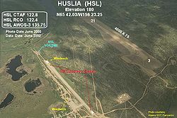
IATA: HSL – ICAO: PAHL – FAA LID: HLA Summary Airport type Public Owner State of Alaska DOT&PF - Northern Region Location Huslia, Alaska Elevation AMSL 213 ft / 65 m Coordinates 65°41′52″N 156°21′05″W / 65.69778°N 156.35139°W Runways Direction Length Surface ft m 3/21 4,000 1,219 Gravel Source: Federal Aviation Administration[1] Huslia Airport (IATA: HSL, ICAO: PAHL, FAA LID: HLA) is a state-owned public-use airport located one nautical mile (1.85 km) east of the central business district of Huslia,[1] in the Yukon-Koyukuk Census Area of the U.S. state of Alaska.
Although most U.S. airports use the same three-letter location identifier for the FAA and IATA, this airport is assigned HLA by the FAA[1] and HSL by the IATA[2] (which assigned HLA to Lanseria Airport in Lanseria, South Africa[3]). The airport's ICAO identifier is PAHL.[4]
Contents
Facilities
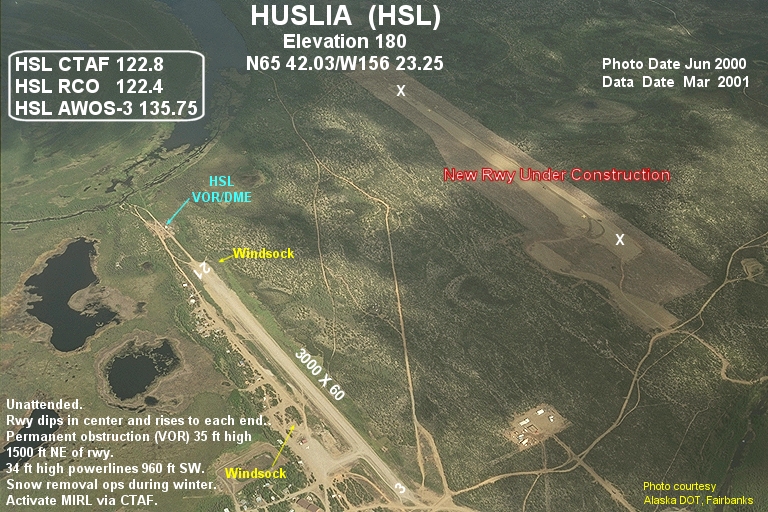
Huslia Airport covers an area of 203 acres (82 ha) at an elevation of 220 feet (67 m) above mean sea level. It has one runway designated 3/21 with a gravel surface measuring 4,000 by 75 feet (1,219 x 23 m).[1] This replaced the former runway which had the same designation and measured 3,000 by 60 feet (914 × 18 m).[5]
Airlines and non-stop destinations
- Arctic Circle Air (Fairbanks) [6]
- Frontier Flying Service (Galena) [7]
- Warbelow's Air Ventures (Fairbanks, Hughes)
- Wright Air Service (Fairbank, Hughes, Tanana) [8]
References
- ^ a b c d FAA Airport Master Record for HLA (Form 5010 PDF), effective 2009-07-02.
- ^ "HSL / PAHL - Huslia, Alaska". Great Circle Mapper. http://gc.kls2.com/airport/HSL. Retrieved 2009-08-07.
- ^ "HLA / FALA - Lanseria Airport, South Africa". Aviation Safety Network. http://aviation-safety.net/database/airport/airport.php?id=HLA. Retrieved 2009-08-07.
- ^ "Alaskan ICAO Identifiers". Federal Aviation Administration. http://www.faa.gov/air_traffic/publications/atpubs/LID/L_G2.htm. Retrieved 2009-08-07.
- ^ Annotated photo showing new runway under construction (JPG), FAA Alaska Region, June 2000.
- ^ "Fairbanks Schedule". Arctic Circle Air. 2006-04-24. http://www.arcticcircleair.com/FAI%20Schedule.htm.
- ^ "2007 Timetable" (PDF). Frontier Flying Service. http://www.frontierflying.com/timetable-ffs.pdf. Retrieved 2007-08-31.
- ^ "Huslia Schedules and Fares". Wright Air Service. May 2006. http://www.wrightair.net/Huslia.htm.
External links
- FAA Alaska airport diagram (GIF)
- FAA Terminal Procedures for HLA, effective 20 October 2011
- Resources for this airport:
- AirNav airport information for PAHL
- ASN accident history for HSL
- FlightAware airport information and live flight tracker for PAHL
- NOAA/NWS latest weather observations for PAHL
- SkyVector aeronautical chart for HLA
Categories:- Airports in the Yukon–Koyukuk Census Area, Alaska

Wikimedia Foundation. 2010.