- Oberstaufenbach
-
Oberstaufenbach 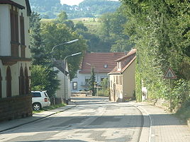


 OberstaufenbachLocation of Oberstaufenbach within Kusel district
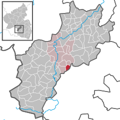
Coordinates 49°30′53″N 7°30′33″E / 49.51472°N 7.50917°ECoordinates: 49°30′53″N 7°30′33″E / 49.51472°N 7.50917°E Administration Country Germany State Rhineland-Palatinate District Kusel Municipal assoc. Altenglan Mayor Wilhelm Junk Basic statistics Area 2.68 km2 (1.03 sq mi) Elevation 254 m (833 ft) Population 255 (31 December 2010)[1] - Density 95 /km2 (246 /sq mi) Other information Time zone CET/CEST (UTC+1/+2) Licence plate KUS Postal code 66879 Area code 06385 Website altenglan.de Oberstaufenbach is a municipality in the district of Kusel, in Rhineland-Palatinate, western Germany. It is situated about 15 km from Ramstein Air Base.
Contents
Geography
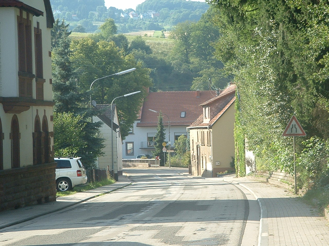
Oberstaufenbach is a typical linear village, formed around the main thoroughfare, the Landesstraße 367. The village, located within the North Palatine Uplands, has a population of 258. It is situated at the foot of the Potzberg mountain, at an elevation of 254 metres in the valley of the stream Reichenbach, a tributary of the river Glan.
To the north, Oberstaufenbach borders on Niederstaufenbach, to the south-east on Reichenbach-Steegen and to the southwest on Neunkirchen am Potzberg. Oberstaufenbach is part of the collective municipality (Verbandsgemeinde) Altenglan. The residential area Birkenhof also belongs administratively to Oberstaufenbach.[2] Due to its proximity to Ramstein Air Base, many NATO personnel reside in Oberstaufenbach, the vast majority of which are members of the United States Armed Forces and their families,[3] who make up twenty-five percent of Oberstaufenbach's population.[4]
History
Oberstaufenbach was first mentioned in 945 and again in a document from 1345. During the Middle Ages and the early modern period it changed hands frequently. In 1733 it became part of the Electoral Palatinate and, following the Congress of Vienna in 1815, was incorporated, together with the rest of the territory of the former Electoral Palatinate to the west of the river Rhine, into the recently founded Kingdom of Bavaria. After the Second World War, Oberstaufenbach became part of the newly formed federal state of Rhineland-Palatinate, and, as a result of the restructuring of local administrations in 1972, it formed, together with 15 other municipalities, the collective municipality of Altenglan.[5]
Government and politics
Local council
During the last local elections on 7 June 2009, using the first-past-the-post system, six members were elected to the local council, which also includes the unsalaried local mayor.[6]
Coat of arms
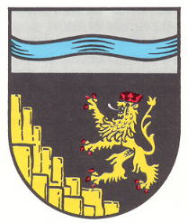
The blue waving band represents the stream (Bach) and the rocks allude to Stauf, originally a drinking vessel, but also used to denote cone-shaped hills and mountains. The Lion ramapant in or refers to the Electoral Palatinate of which Oberstaufenbach was once part of.[7]
Economy and infrastructure
At a distance of 14 km the motorway A 62 can be reached via junction Glan-Münchweiler. The nearest train station is at Theisbergstegen, connecting to the Glan Valley Railway.
Sights
On a top of a hill to the north-east, the remains of a medieval castle, the so-called Heidenburg, dating from around 1100, are still visible.[8]
Notable people
- Daniel Kuntz (19 April 1860 - 1959), co-founder of Boston Symphony Orchestra
References
- ^ "Bevölkerung der Gemeinden am 31.12.2010" (in German). Statistisches Landesamt Rheinland-Pfalz. 31 December 2010. http://www.statistik.rlp.de/fileadmin/dokumente/berichte/A1033_201022_hj_G.pdf.
- ^ "Verzeichnisse und Adressarien" (in German) (pdf). Statistisches Landesamt Rheinland-Pfalz. June 2010. p. 97. http://www.statistik.rlp.de/fileadmin/dokumente/berichte/A1132_201001_ur_G.pdf. Retrieved 15 July 2011.
- ^ Grabski-Kieron, Ulrike. "Umnutzung Alter Gebäude" (in German) (pdf). p. 266. http://www.ism.rlp.de/no_cache/staedte-und-gemeinden/dorferneuerung/umnutzung-alter-gebaeude/?cid=30904&did=23613&sechash=e23fea92. Retrieved 15 July 2011.
- ^ Keck, Thomas (19-10-2006). "Oberstaufenbach" (in German). Südwestrundfunk. http://www.swr.de/landesschau-rp/hierzuland/-/id=100766/nid=100766/did=2353876/1tdwp6z/. Retrieved 15 July 2011.
- ^ "Oberstaufenbach im Wandel der Zeit" (in German). Gemeinde Oberstaufenbach. http://www.oberstaufenbach.de/chronik/. Retrieved 15 July 2011.
- ^ Rheinland-Pfalz. "Gemeinderatswahlen - Oberstaufenbach" (in German). Landeswahlleiter. http://wahlen.rlp.de/kw/wahlen/2009/gemeinderatswahlen/ergebnisse/3360107100.html. Retrieved 15 July 2011.
- ^ "Wappen" (in German). Gemeinde Oberstaufenbach. http://www.oberstaufenbach.de/wappen/. Retrieved 15 July 2011.
- ^ Keck, Thomas (19-10-2006). "Oberstaufenbach" (in German). Südwestrundfunk. http://www.swr.de/landesschau-rp/hierzuland/-/id=100766/nid=100766/did=2353876/1tdwp6z/. Retrieved 15 July 2011.
External links
References
- ^ "Bevölkerung der Gemeinden am 31.12.2010" (in German). Statistisches Landesamt Rheinland-Pfalz. 31 December 2010. http://www.statistik.rlp.de/fileadmin/dokumente/berichte/A1033_201022_hj_G.pdf.
- ^ "Verzeichnisse und Adressarien" (in German) (pdf). Statistisches Landesamt Rheinland-Pfalz. June 2010. p. 97. http://www.statistik.rlp.de/fileadmin/dokumente/berichte/A1132_201001_ur_G.pdf. Retrieved 15 July 2011.
- ^ Grabski-Kieron, Ulrike. "Umnutzung Alter Gebäude" (in German) (pdf). p. 266. http://www.ism.rlp.de/no_cache/staedte-und-gemeinden/dorferneuerung/umnutzung-alter-gebaeude/?cid=30904&did=23613&sechash=e23fea92. Retrieved 15 July 2011.
- ^ Keck, Thomas (19-10-2006). "Oberstaufenbach" (in German). Südwestrundfunk. http://www.swr.de/landesschau-rp/hierzuland/-/id=100766/nid=100766/did=2353876/1tdwp6z/. Retrieved 15 July 2011.
- ^ "Oberstaufenbach im Wandel der Zeit" (in German). Gemeinde Oberstaufenbach. http://www.oberstaufenbach.de/chronik/. Retrieved 15 July 2011.
- ^ Rheinland-Pfalz. "Gemeinderatswahlen - Oberstaufenbach" (in German). Landeswahlleiter. http://wahlen.rlp.de/kw/wahlen/2009/gemeinderatswahlen/ergebnisse/3360107100.html. Retrieved 15 July 2011.
- ^ "Wappen" (in German). Gemeinde Oberstaufenbach. http://www.oberstaufenbach.de/wappen/. Retrieved 15 July 2011.
- ^ Keck, Thomas (19-10-2006). "Oberstaufenbach" (in German). Südwestrundfunk. http://www.swr.de/landesschau-rp/hierzuland/-/id=100766/nid=100766/did=2353876/1tdwp6z/. Retrieved 15 July 2011.
Categories:- Municipalities in Rhineland-Palatinate


Wikimedia Foundation. 2010.