- Pennsylvania Route 89
-
PA Route 89
Route information Maintained by PennDOT Length: 47.86 mi[1] (77.02 km) Existed: 1928 – present Major junctions South end: 
 PA 8/PA 27 in Titusville
 US 6 near Elgin
 I-86 in Greenfield Township
 I-90 in North East Township
 US 20 in North East
North end:  PA 5 near North East
Location Counties: Crawford, Erie Highway system Roads in Pennsylvania
Interstate • US • State • Legislative←  PA 88
PA 88I-90 →Pennsylvania Route 89 is a 50-mile (80 km) long north–south state highway located in northwestern Pennsylvania. The southern terminus of the route is at Pennsylvania Route 8 and Pennsylvania Route 27 in Titusville. The northern terminus is at Pennsylvania Route 5 north of North East.
Contents
Route description
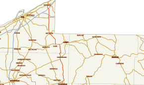
PA 89 begins running north on Franklin Street in Titusville just after the PA 8/27 junction. PA 89 runs northeast out of the city before arcing back around to the north and passing through the town of Vrooman. The highway then bypasses Rome and Buell Corners to the east and then continues north through Hatchtown. West of Spartansburg, PA 89 forms a brief concurrency with PA 77. PA 89 then crosses over into Erie County.
PA 89 continues north to US 6, which it overlaps with from Lovell to Elgin. After splitting off to the north once again, the highway turns more northwest and meets Pennsylvania Route 8 south of Wattsburg. The two routes overlap through Wattsburg (where they meet the western terminus of PA 474) and split up in Lowville. At Colt Station, PA 89 crosses PA 430. North of the PA 430 junction, PA 89 has an interchange with Interstate 86 (exit 3). 4 miles (6 km) later, PA 89 has an interchange with Interstate 90 (exit 41). PA 89 then enters North East. There, it serves as the western terminus of PA 426 before crossing US 20. PA 89 then comes to an end at PA 5, near Lake Erie.
History
PA 89 was established in 1928.[citation needed] In 1930, the highway ran from U.S. Route 6 in Beaver Dam to U.S. Route 20 in North East. By 1941, PA 89 was extended south to the current southern terminus at Titusville. The northern terminus was also extended to Pennsylvania Route 5 in North East.[2][3]
Major intersections
County Location Mile[1] Destinations Notes Crawford Titusville 0.00 PA 8 / PA 27 (Central Avenue)Sparta Township 13.62  PA 77 west
South end of PA 77 concurrency 14.77 PA 77 eastNorth end of PA 77 concurrency Erie Concord Township 16.92  PA 178 (Concord Road)
Eastern terminus of PA 178 22.17 US 6 east (Grand Army of the Republic Highway)Elgin 23.75 US 6 west (Grand Army of the Republic Highway)Amity Township 30.74 PA 8 south (Main Street)South end of PA 8 concurrency Wattsburg 31.24  PA 474 (Jamestown Street)
Western terminus of PA 474. Venango Township 32.82 PA 8 northNorth end of PA 8 concurrency Greenfield Township 39.37  PA 430 (Station Road)
40.71 I-86Exit 3 (I-86) North East Township 44.29 I-90Exit 41 (I-90) North East 45.97  PA 426 (Grahamville Street)
Northern terminus of PA 426 46.45 US 20 (Main Street)North East Township 47.86  PA 5 (Lake Road) / LECT
1.000 mi = 1.609 km; 1.000 km = 0.621 mi References
- ^ a b DeLorme Street Atlas USA 2007 software, Toogle Measure Tool and Driving Directions
- ^ Pennsylvania Department of Highways (1930). Highway Map of Pennsylvania (front side) (Map). ftp://ftp.dot.state.pa.us/public/pdf/BPR_pdf_files/Maps/Statewide/Historic_OTMs/1930fr.pdf. Retrieved 2007-09-10.
- ^ Pennsylvania Department of Highways (1940). Highway Map of Pennsylvania (front side) (Map). ftp://ftp.dot.state.pa.us/public/pdf/BPR_pdf_files/Maps/Statewide/Historic_OTMs/1940fr.pdf. Retrieved 2007-09-10.
External links
Categories:- State highways in Pennsylvania
- Transportation in Crawford County, Pennsylvania
- Transportation in Erie County, Pennsylvania


Wikimedia Foundation. 2010.