- Sailing stones
-
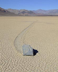
 A sailing stone in Racetrack Playa.
Sailing stones, sliding rocks, and moving rocks all refer to a geological phenomenon where rocks move in long tracks along a smooth valley floor without human or animal intervention. They have been recorded and studied in a number of places around Racetrack Playa, Death Valley, where the number and length of travel grooves are notable. The force behind their movement is not confirmed and is the subject of research.
The stones move only every two or three years and most tracks develop over three or four years. Stones with rough bottoms leave straight striated tracks while those with smooth bottoms wander. Stones sometimes turn over, exposing another edge to the ground and leaving a different track in the stone's wake.
Trails differ in both direction and length. Rocks that start next to each other may travel parallel for a time, before one abruptly changes direction to the left, right, or even back the direction it came from. Trail length also varies – two similarly sized and shaped rocks may travel uniformly, then one could move ahead or stop in its track.
Contents
Description
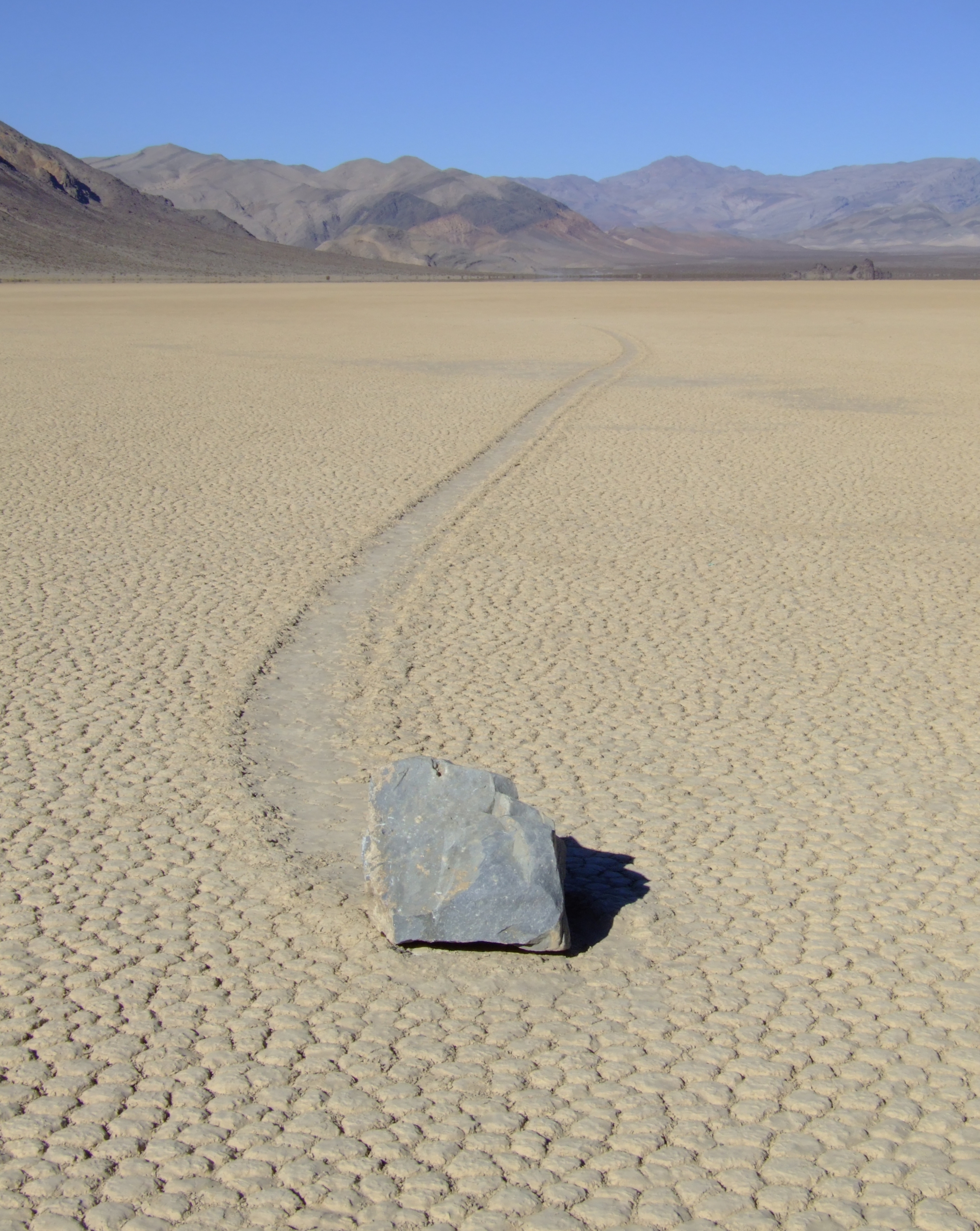
 Tracks are sometimes non-linear.
Most of the so-called sailing stones originate from an 850 ft-high (260 m) hillside made of dark dolomite on the south end of the playa, but some are intrusive igneous rock from adjacent slopes (most of those being tan-colored feldspar-rich syenite). Tracks are often tens to hundreds of feet long, about 3 to 12 inches (8 to 30 cm) wide, and typically much less than an inch (2.54 cm) deep.
A balance of specific conditions are thought to be needed for stones to move:
- a saturated yet non-flooded surface,
- a thin layer of clay,
- very strong gusts as initiating force, and
- strong sustained wind to keep stones going
Research history
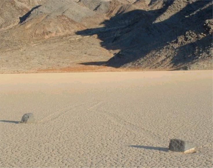
 Two rocks in Racetrack Playa.
Geologists Jim McAllister and Allen Agnew mapped the bedrock of the area in 1948 and made note of the tracks. Naturalists from the National Park Service later wrote more detailed descriptions and Life magazine featured a set of photographs from the Racetrack. Speculation about how the stones move started at this time. Various and sometimes idiosyncratic possible explanations have been put forward over the years that have ranged from the supernatural to the very complex. Most hypotheses favored by interested geologists posit that strong winds when the mud is wet are at least in part responsible. Some stones weigh as much as a human, which some researchers, such as geologist George M. Stanley, who published a paper on the topic in 1955, feel is too heavy for the area's wind to move. They maintain that ice sheets around the stones either help to catch the wind or move in ice floes.
Bob Sharp and Dwight Carey started a Racetrack stone movement monitoring program in May 1972. Eventually thirty stones with fresh tracks were labeled and stakes were used to mark their locations. Each stone was given a name and changes in the stones' position were recorded over a seven year period. Sharp and Carey also tested the ice floe hypothesis by corralling selected stones. A corral 5.5 feet (1.7 m) in diameter was made around a 3 inches (7.6 cm) wide, 1 pound (0.45 kg) track-making stone with seven rebar segments placed 25 to 30 inches (63 to 76 cm) apart. If a sheet of ice around the stones either increased wind-catching surface area or helped move the stones by dragging them along in ice floes, then the rebar should at least slow down and deflect the movement. Neither appeared to occur; the stone barely missed a rebar as it moved 28 feet (8.5 m) to the northwest out of the corral in the first winter. Two heavier stones were placed in the corral at the same time; one moved five years later in the same direction as the first but its companion did not move during the study period. This indicated that if ice played a part in stone movement, then ice collars around stones must be small.
Ten of the initial twenty-five stones moved in the first winter with Mary Ann (stone A) covering the longest distance at 212 feet (65 m). Two of the next six monitored winters also saw multiple stones move. No stones were confirmed to have moved in the summer and some winters none or only a few stones moved. In the end all but two of the thirty monitored stones moved during the seven year study. At 2.5 inches (6.4 cm) in diameter, Nancy (stone H) was the smallest monitored stone. It also moved the longest cumulative distance, 860 feet (260 m), and the greatest single winter movement, 659 feet (201 m). The largest stone to move was 80 pounds (36 kg).
Karen (stone J) is a 29 by 19 by 20 inches (74 by 48 by 51 cm) block of dolomite and weighs an estimated 700 pounds (318 kg). Karen did not move during the monitoring period. The stone may have created its 570 foot long straight and old track from momentum gained from its initial fall onto the wet playa. However, Karen disappeared sometime before May 1994, possibly during the unusually wet winter of 1992 to 1993. Removal by artificial means is considered unlikely due to the lack of associated damage to the playa that a truck and winch would have caused. A possible sighting of Karen was made in 1994 a half mile 800 m from the playa. Karen was rediscovered by San Jose geologist Paula Messina in 1996.[1]
Professor John Reid led six research students from Hampshire College and the University of Massachusetts in a follow-up study in 1995. They found highly congruent trails from stones that moved in the late 1980s and during the winter of 1992-1993. At least some stones were proved beyond a reasonable doubt to have been moved in ice floes that may be up to half a mile 800 m wide. Physical evidence included swaths of lineated areas that could only have been created by moving thin sheets of ice. So wind alone and wind in conjunction with ice floes are thought to be motive forces.
 Another sailing stone in Racetrack Playa.
Physicists studying the phenomenon in 1995 found that winds blowing on playa surfaces can be compressed and intensified. They also found that boundary layers (the region just above ground where winds are slower due to ground drag) on these surfaces can be as low as 2 inches (5.1 cm). This means that stones just a few inches high feel the full force of ambient winds and their gusts, which can reach 90 miles per hour (140 km/h) in winter storms. Such gusts are thought to be the initiating force while momentum and sustained winds keep the stones moving, possibly as fast as a moderate run (only half the force required to start a stone sailing is needed to keep it in motion).
Wind and ice both are the favoured hypothesis for these mysterious sliding rocks. Noted in Don J. Easterbrook's "Surface Processes and Landforms", he mentioned that because of the lack of parallel paths between some rock paths, this could be caused by the breaking up of ice resulting in alternate routes. Even though the ice breaks up into smaller blocks, it is still necessary for the rocks to slide.
A study published in 2011 postulated that small rafts of ice form around the rocks and when the local water level rises, the rocks are buoyantly floated off the soft bed thus reducing the reaction and friction forces at the bed. Since this effect depends on reducing friction, and not by increasing the wind drag, these ice cakes need not have a particularly large surface area if the ice is adequately thick, as the minimal friction allows the rocks to be moved by arbitrarily light winds.[2][3]
References
- ^ http://ngm.nationalgeographic.com/2007/11/death-valley/cahill-text/3
- ^ Lorenz, Ralph; Jackson, Brian K.; Barnes, Jason W.; Spitale, Joe; and Keller, John M. (01/2011). "Ice rafts not sails: Floating the rocks at Racetrack Playa". American Journal of Physics 79 (1): 37–42. doi:10.1119/1.3490645. http://barnesos.net/publications/papers/2011.01.AJP.Lorenz.Racetrack.Rafts.pdf. Retrieved 24 June 2011.
- ^ Schewe, Phillip. "Ice offers possible explanation for Death Valley's mysterious 'self-moving' rocks". PhysOrg.com. http://www.physorg.com/news/2011-02-ice-explanation-death-valley-mysterious.html. Retrieved 24 June 2011.
 In Death Valley, California
- Messina, P., 1998, The Sliding Rocks of Racetrack Playa, Death Valley National Park, California: Physical and Spatial Influences on Surface Processes. Published doctoral dissertation, Department of Earth and Environmental Sciences, City University of New York, New York. University Microfilms, Incorporated, 1998.
- Messina, P., Stoffer, P., and Clarke, K. C. Mapping Death Valley's Wandering Rocks. GPS World April, 1997: p. 34-44
- Sharp, R.P., and A.F. Glazier, 1997, Geology Underfoot in Death Valley and Owens Valley. Mountain Press Publishing Company, Missoula. ISBN 0-87842-362-1
- Stanley, G. M., 1955, Origin of playa stone tracks, Racetrack Playa, Inyo County, California. Geological Society of America Bulletin, v. 66, p. 1329-1350.
- Reid, J.B., Jr., Bucklin, E.P., Copenagle, L., Kidder, J., Pack, S. M., Polissar, P.J., and Williams, M. L., 1995, Sliding rocks at the Racetrack, Death Valley: What makes them move?. Geology v. 23, p. 819-822
- Sharp, R.P., Carey, D. L., Reid, J.B., Jr., Polissar, P.J., and Williams, M.L., 1996, Sliding rocks at the Racetrack, Death Valley: What makes them move?; Discussion and Reply. Geology, v. 25, p. 766-767
External links
- The Sliding Rocks of Racetrack Playa by Paula Messina
- The Mystery of the Rocks on the Racetrack at Death Valley by Lena Fletcher and Anne Nester
- http://www.physicsforums.com/showthread.php?p=437132
- Moving Rocks of Death Valley's Racetrack Playa by Brian Dunning
- Why Are Death Valley's Rocks Moving Themselves? by Philip Schewe (FoxNews)
Death Valley and Death Valley National Park Fauna, flora and minerals Amargosa springsnail · Borax · Chuckwalla · Death Valley monkeyflower · Death Valley pupfish · Death Valley June beetle · Devil's Hole pupfish · Saratoga Springs pupfish
History Amargosa Opera House and Hotel · Badwater · Death Valley Railroad · Greenwater · Harmony Borax Works · Lake Manly (Badwater Basin) · Skidoo · Tonopah and Tidewater Railroad · Twenty-mule team
Places Amargosa Range / River / Valley · Ash Meadows NWR · Badwater Basin · Ballarat · Beatty · Black Mountains · Chloride City · Cottonwood Mountains · Darwin Falls · Death Valley Junction · Eureka Valley / Dunes · Funeral Mountains · Furnace Creek · Panamint City / Range / Springs / Valley · Racetrack · Rhyolite · Saline Valley · Saratoga Springs · Scotty's Castle · Stovepipe Wells · Telescope Peak · Trona · Ubehebe Crater · Zabriskie Point
Transportation Categories:


Wikimedia Foundation. 2010.