- Croatian Littoral
-
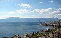 Kvarner Bay
The Croatian Littoral (Croatian: Hrvatsko primorje or Primorje, Hungarian: Horvát partvidék, German: Kroatisches Küstenland) is a geographical term that refers to the narrow coastal strip (littoral) along the Adriatic Sea in Croatia extending from east the city Rijeka south to Karlobag. The coast from Karlobag southward is usually considered part of Dalmatia.
Along the Croatian Littoral are numerous tourist destinations such as Bakar, Kraljevica, Crikvenica, Bribir, Novi Vinodolski, Susak and Senj. Adjacent to the continental coastal region is the Kvarner Bay which is usually considered part of the Croatian Littoral and includes the largest islands of Croatia: Krk, Cres, and Rab (see also list of Croatian islands). The Kvarner Bay is often included in the Croatian Littoral but can also be grouped with Istria as the Northern Croatian Littoral (Sjeverno hrvatsko primorje).
The high mountains of the region help the coast maintain a milder Mediterranean climate relative to inland areas. The area is also known for the Bora, a type of katabatic wind.
History
The term Croatian Littoral developed after Austro-Hungarian Ausgleich of 1867, when Hungary attained large measure of autonomy Cisleithanian Austria. Unlike Istria and Dalmatia which were crown lands (Kronland) of the Austrian Emperor, the Littoral was part of the Hungarian-ruled Kingdom of Croatia and Hungarian authorities saw the area as the Hungarian gateway to the Adriatic. Just as the Cisleithanian Austrian coast (including Istria) was called the Austrian Littoral, the Hungarians termed their possession the Hungarian Littoral (Magyar partvidék).
See also
Categories:- Geography of Croatia
- Croatia stubs
- European history stubs

Wikimedia Foundation. 2010.