- Yonaguni
-
For the breed of horse, see Yonaguni (horse). For the administrative division, see Yonaguni, Okinawa.
 Yonaguni
Yonaguni (与那国島 Yonaguni-jima, Yonaguni: Dunan) is one of the Yaeyama Islands and the westernmost inhabited island of Japan. It is the last of the Ryukyu Islands chain, and lies 108 kilometers (67 mi) from the east coast of Taiwan, between the East China Sea and the Pacific Ocean proper.
Japan intends to station 100 troops on Yonaguni to counter the buildup of Chinese forces in the area.[1]
Contents
Geography
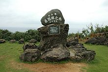 Marker for Japan's westernmost point, Cape Irizaki
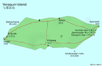
The island has an area of 28.88 km2 (11.15 sq mi), a population around 1700, an annual mean air temperature of 23.9 °C, and annual precipitation of 3000 mm. All islands are under jurisdiction of the town of Yonaguni, Yaeyama Gun, Okinawa and there are three towns: Sonai, Kubura and Higawa. It was incorporated under the control of the Ryūkyū royal court in 1610.
Yonaguni, more specifically Cape Irizaki 24°26′58″N 122°56′01″E / 24.44944°N 122.93361°E at the western tip of the island, is the westernmost point of Japan. Taiwan is said to be visible from Irizaki on a clear day.
History
During the last ice age, Yonaguni was part of the continent.
In the 12th century, it was incorporated to the Ryūkyū Kingdom. In the 17th century, it was incorporated into the Japanese han of Satsuma. By 1879, the island was formally incorporated into Japan.
Until the early 20th century, Yonaguni was part of the larger Yaeyama village, which included the neighboring Yaeyama Islands. In 1948, it became an independent village. From 1945 to 1972, it was occupied by the United States and was then returned to Japan to form a part of Okinawa Prefecture.
On May 4, 1998, a part of the island was destroyed by a submarine earthquake.
Notable features
Yonaguni is known in Japan for the hanazake, a 120-proof rice-based distilled beverage (awamori) produced only on the island.
The island is also the only natural habitat of a distinctive horse breed, the Yonaguni horse.
Yonaguni is a popular attraction for divers because of the large numbers of hammerhead sharks that gather in the surrounding waters during winter.
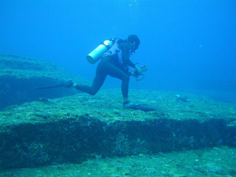
Yonaguni Monument
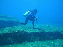 Sunken formationsMain article: Yonaguni Monument
In the 1980s, local divers discovered a striking underwater rock formation off the southernmost point of the island. This so-called Yonaguni Monument has staircase-like terraces with flat sides and sharp corners. Although the majority of the academic society regard the rock formation as natural joint, Masaaki Kimura, a professor of seismology in University of the Ryukyus and some media believe it is an artificial (or artificially modified) structure engraved or built 2,000 to 3,000 years ago. [2]
Patrick D. Nunn, Professor of Oceanic Geoscience at the University of the South Pacific, has studied these structures extensively and notes that the structures below the water continue above and are slate that "has been fashioned solely by natural processes" and that "there seems no reason to suppose that they are artificial."[3]
Transportation
Yonaguni Airport serves Yonaguni island.
See also
References
- ^ "Japan wary of China military threat." Al Jazeera, 17 December 2010.
- ^ "Yonaguni, Japan". New Scientist (2736). 2009-11-25. http://www.newscientist.com/article/mg20427361.500-yonaguni-japan.html. Retrieved 2010-07-06.
- ^ Nunn, Patrick D. Vanished Islands and Hidden Continents of the Pacific University of Hawaii Press (15 Aug 2008)ISBN: 978-0824832193 p.127
External links
Categories:- Extreme points of Japan
- Islands of Okinawa Prefecture

Wikimedia Foundation. 2010.