- New Jersey Route 65
-
Route 65

Route information Maintained by New Jersey State Highway Department Length: 4.12 mi[3][4] (6.63 km) Existed: 1953 (1939 as SHR 25B)[1] – by 1963[2] Major junctions South end: 
 US 1 / US 9 in Newark
North end: 
US 1 Truck / US 9 Truck in NewarkLocation Counties: Essex Highway system New Jersey State Highway Routes
Interstate and US←  Route 64
Route 66  →
→Route 65 is a former state highway in the city of Newark, New Jersey. The route went for 4.12 miles (6.63 km) along Port Street and Doremus Avenue through the industrial districts of the city. Route 65 began at an intersection with U.S. Route 1 and 9 near Newark Liberty International Airport. The route crossed over the New Jersey Turnpike along Port Street until an intersection with Doremus Avenue, where it turned northward for the rest of the distance, terminating at an intersection with U.S. Route 1 and 9 Truck.
Route 65 was originally planned in 1939 as a spur of Route 25, Route 25B, in Newark to connect that route with Route 25T (now U.S. Route 1/9 Truck). The route lasted for 14 years, until January 1, 1953, when the 1953 New Jersey state highway renumbering occurred. Route 25B was decommissioned on that day, along with its parent route, Route 25. Route 25B was redesigned as Route 65, and was removed from the state highway system by 1963. The two roads are now maintained by the city of Newark.
Contents
Route description
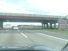 Port Street bridge over the New Jersey Turnpike
Route 65 began at an intersection with U.S. Route 1 and 9 in the area of Newark Liberty International Airport in the city of Newark. The route progressed eastward along Port Street, a divided highway for a short distance.[3] The route crossed the access road to the airport before crossing over the newly constructed New Jersey Turnpike south of Interchange 14. From there, Route 65 continued as Port Street but as one roadway into the industrial districts in Newark. The route progressed further over a railroad before intersecting with Doremus Avenue, where Route 65 turned northward off of Port Street.[5] Both Port Street and Doremus Avenue dead-end right after this respective intersection, Doremus Avenue to the south and Port Street to the east.[3][4]
From there, Route 65 headed northward along Doremus Avenue, crossing over the Newark Bay Extension (Interstate 78) just north of the intersection. The route continued through the industrial district, reaching higher in elevation on a bridge over the Central Railroad of New Jersey. From there, the route paralleled the turnpike's mainline along Doremus Avenue. At the intersection with Raymond Boulevard, Route 65 became a divided highway once again,[4] terminating at an intersection with U.S. Route 1/9 Truck in the city of Newark.[5]
History
 Route 25B (1939-1953)
Route 65 was originally designated in 1939 as State Highway Route 25B, a spur off of State Highway Route 25 (now U.S. Route 1 and 9) at a traffic circle near the Newark Municipal Airport (now Newark Liberty International Airport). The route was then to commence along Port Street and Doremus Avenue to an intersection with State Highway Route 25T (now U.S. Route 1 and 9 Truck).[6] Route 25B remained intact along the alignment of Port Street and Doremus Avenue until January 1, 1953. On that day, the New Jersey State Highway Department renumbered routes in the state, and eliminated Route 25 entirely. Due to decommissioning of Route 25, Route 25B was renumbered to Route 65, eliminating the relation to former Route 25 or U.S. Route 1 and 9.[1] Route 65 remained on the Port Street and Doremus Avenue alignment for a short time, and was completely eliminated from the state system by 1963.[2] Port Street and Doremus Avenue are both now maintained by the city of Newark but both are of the National Highway System as of 2009.[3][4] In 2001, the bridge over the Central Railroad of New Jersey was reconstructed.[7]
Major intersections
The entire route was in Newark, Essex County.
Mile[3][4] Destinations Notes 0.00 US 1 / US 9Southern terminus of Route 65 1.90 Port Street Route 65 turned off at Doremus Avenue, where Port Street continued to a dead-end 4.12
US 1 Truck / US 9 TruckNorthern terminus of Route 65 1.000 mi = 1.609 km; 1.000 km = 0.621 mi See also
 U.S. Roads portal
 New Jersey portal
- New Jersey Route 158 - another short-lived spur of Route 25.
References
- ^ a b 1953 renumbering. New Jersey Department of Highways. http://en.wikisource.org/wiki/1953_New_Jersey_state_highway_renumbering. Retrieved July 31, 2009
- ^ a b American Oil Company (1963). New Jersey (Map). Cartography by Rand McNally Incorporated.
- ^ a b c d e "Port Street Straight Line Diagram" (PDF). New Jersey Department of Transportation. 2009. pp. 1. http://www.state.nj.us/transportation/refdata/sldiag/07141819__-.pdf. Retrieved August 31, 2009.
- ^ a b c d e "Doremus Avenue Straight Line Diagram" (PDF). New Jersey Department of Transportation. 2009. pp. 1–2. http://www.state.nj.us/transportation/refdata/sldiag/07141820__-.pdf. Retrieved August 31, 2009.
- ^ a b Microsoft Inc. (2009). Bing Maps - Overview map of Route 65 (Map). http://www.bing.com/maps/?FORM=Z9LH11#JnJ0cD1wb3MucXNoMGtmOHRubXl2X25lYXIrMjk3K0UrUG9ydCtTdCUyYytOZXdhcmslMmMrTmV3K0plcnNleSswNzExNCUyYytVbml0ZWQrU3RhdGVzX19fZV8lN2Vwb3MucXNqM2hzOHRuemM2X25lYXIrNzc5K0RvcmVtdXMrQXZlJTJjK05ld2FyayUyYytOZXcrSmVyc2V5KzA3MTE0JTJjK1VuaXRlZCtTdGF0ZXNfX19lXyU3ZXBvcy5xc2o1bmI4dGt5dndfbmVhcitFK1BvcnQrU3QrJTI2YW1wJTNiK1JhbXAlMmMrTmV3YXJrJTJjK05ldytKZXJzZXkrMDcxMTQlMmMrVW5pdGVkK1N0YXRlc19fX2VfJnJ0b3A9MCU3ZTA=. Retrieved August 31, 2009.
- ^ ROUTE NO. 25B. Beginning on Route No. 25 of the present State highway system in the city of Newark, county of Essex, in the vicinity of the traffic circle at the Newark Municipal Airport, thence along Port street and Doremus avenue connecting with the Lincoln Highway, which is part of the present State highway system Route No. 25. New Jersey State Assembly. 1939
- ^ Inventory, National Bridge (2007). Structure Number: ++++++++0751160 (2007 ed.). United States Department of Transportation.
External links
- Moraeski, Dan (2009). "65". Alps Roads. http://www.alpsroads.net/roads/nj/log/6.html#65. Retrieved August 24, 2009.
- Moraeski, Dan (2009). "25B". Alps Roads. http://www.alpsroads.net/roads/nj/log/3.html#25b. Retrieved August 24, 2009.
Categories:- State highways in New Jersey
- Transportation in Newark, New Jersey


Wikimedia Foundation. 2010.