- Müswangen
-
Müswangen 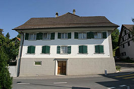
Country Switzerland 
Canton Lucerne District Hochdorf 47°14′N 8°17′E / 47.233°N 8.283°ECoordinates: 47°14′N 8°17′E / 47.233°N 8.283°E Population 453 (December 2007) - Density 101 /km2 (261 /sq mi) Area 4.50 km2 (1.74 sq mi) Elevation 783 m (2,569 ft) Postal code 6289 SFOS number 1036 Surrounded by Beinwil (Freiamt) (AG), Buttwil (AG), Geltwil (AG), Hämikon, Schongau, Sulz Website www.mueswangen.ch
Profile (German), SFSO statistics
 MüswangenMap of Müswangen
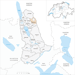
Müswangen is a municipality in the district of Hochdorf in the canton of Lucerne in Switzerland. Since 1 January 2009, it has been part of the municipality of Hitzkirch.
Contents
History
Müswangen is first mentioned in 924 as Milizwaga.[1] It is a combination of two words müssen - "mosses" and wangen - (foot of) so it doesn't really translate.
Geography
Müswangen has an area of 4.5 km2 (1.7 sq mi). Of this area, 70.9% is used for agricultural purposes, while 24.2% is forested. Of the rest of the land, 4.7% is settled (buildings or roads) and the remainder (0.2%) is non-productive (rivers, glaciers or mountains).[2] The municipality is located on the west slope of the Lindenberg mountain.
On 21 May 2006 an attempt to merge Hitzkirch and the surrounding 10 municipalities failed, when five of the eleven voted against the merger.[3] A less ambitious merger was then proposed and accepted, with the municipalities of Gelfingen, Hämikon, Mosen, Müswangen, Retschwil and Sulz joining Hitzkirch on 1 January 2009.[4]
Demographics
Müswangen has a population (as of 2007[update]) of 453, of which 4.6% are foreign nationals. Over the last 10 years the population has grown at a rate of 4.1%. Most of the population (as of 2000[update]) speaks German (95.7%), with Albanian being second most common ( 2.3%) and French being third ( 1.8%).
In the 2007 election the most popular party was the SVP which received 30.2% of the vote. The next three most popular parties were the FDP (28.9%), the CVP (26.5%) and the Green Party (6.8%).
The age distribution of the population (as of 2000[update]) is children and teenagers (0–19 years old) make up 34.6% of the population, while adults (20–64 years old) make up 56.7% and seniors (over 64 years old) make up 8.7%. The entire Swiss population is generally well educated. In Müswangen about 71.9% of the population (between age 25-64) have completed either non-mandatory upper secondary education or additional higher education (either University or a Fachhochschule).
Müswangen has an unemployment rate of 1.05%. As of 2005[update], there were 61 people employed in the primary economic sector and about 24 businesses involved in this sector. 17 people are employed in the secondary sector and there are 5 businesses in this sector. 36 people are employed in the tertiary sector, with 10 businesses in this sector.[2]
The historical population is given in the following table:[1]
year population 1798 307 1850 442 1900 324 1950 259 1980 217 2000 439 References
- ^ a b Müswangen in German, French and Italian in the online Historical Dictionary of Switzerland.
- ^ a b Swiss Federal Statistical Office accessed 18-Aug-2009
- ^ "Die Fusion im Hitzkirchertal kommt nicht zustande – fünf Gemeinden sagen nein – auch Hitzkirch" (in German) (Press release). Kanton Luzern, Staatskanzlei. 21 May 2006. http://www.lu.ch/mm_detail.html?id=3146¶meter=1863. Retrieved 18 August 2009.
- ^ Canton of Lucerne, Office of Municipalities (German) accessed 18 August 2009
Categories:- Villages in the canton of Lucerne
- Former municipalities of the canton of Lucerne


Wikimedia Foundation. 2010.